Clintonville Topo Map Kentucky
To zoom in, hover over the map of Clintonville
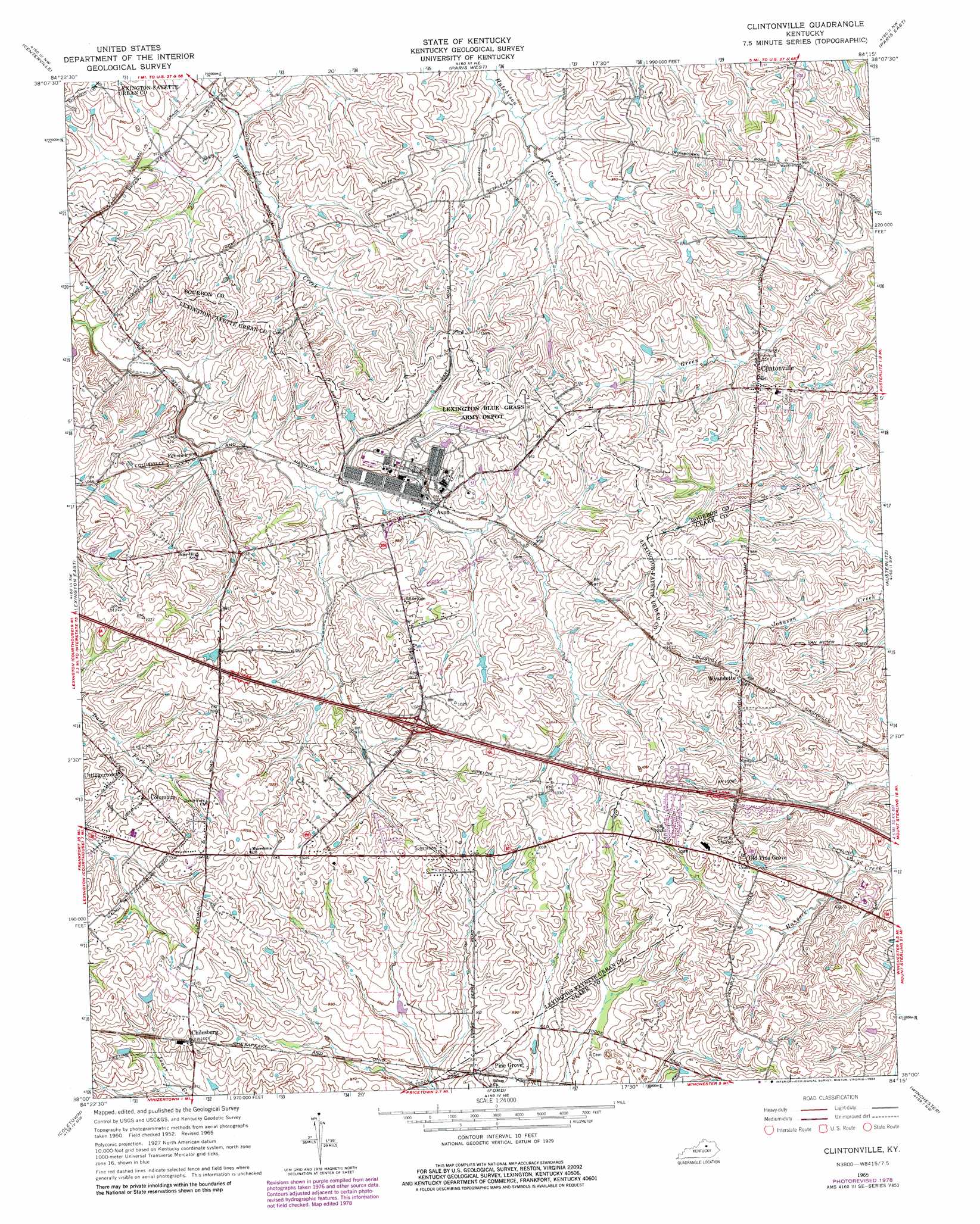
USGS Topo Quad 38084a3 - 1:24,000 scale
| Topo Map Name: | Clintonville |
| USGS Topo Quad ID: | 38084a3 |
| Print Size: | ca. 21 1/4" wide x 27" high |
| Southeast Coordinates: | 38° N latitude / 84.25° W longitude |
| Map Center Coordinates: | 38.0625° N latitude / 84.3125° W longitude |
| U.S. State: | KY |
| Filename: | o38084a3.jpg |
| Download Map JPG Image: | Clintonville topo map 1:24,000 scale |
| Map Type: | Topographic |
| Topo Series: | 7.5´ |
| Map Scale: | 1:24,000 |
| Source of Map Images: | United States Geological Survey (USGS) |
| Alternate Map Versions: |
Clintonville KY 1952, updated 1953 Download PDF Buy paper map Clintonville KY 1965, updated 1967 Download PDF Buy paper map Clintonville KY 1965, updated 1979 Download PDF Buy paper map Clintonville KY 1965, updated 1984 Download PDF Buy paper map Clintonville KY 2010 Download PDF Buy paper map Clintonville KY 2013 Download PDF Buy paper map Clintonville KY 2016 Download PDF Buy paper map |
1:24,000 Topo Quads surrounding Clintonville
Delaplain |
Leesburg |
Shawhan |
Millersburg |
Carlisle |
Georgetown |
Centerville |
Paris West |
Paris East |
North Middletown |
Lexington West |
Lexington East |
Clintonville |
Austerlitz |
Sideview |
Nicholasville |
Coletown |
Ford |
Winchester |
Hedges |
Little Hickman |
Valley View |
Richmond North |
Union City |
Palmer |
> Back to 38084a1 at 1:100,000 scale
> Back to 38084a1 at 1:250,000 scale
> Back to U.S. Topo Maps home
Clintonville topo map: Gazetteer
Clintonville: Airports
Air Castle Airport elevation 276m 905′Creech Army Air Field Heliport elevation 295m 967′
Clintonville: Populated Places
Avon elevation 287m 941′Chilesburg elevation 308m 1010′
Clintonville elevation 303m 994′
Columbus elevation 303m 994′
Fenwick elevation 283m 928′
Old Pine Grove elevation 305m 1000′
Pine Grove elevation 292m 958′
Uttingertown elevation 308m 1010′
Verna Hills elevation 311m 1020′
Wayland Heights Addition elevation 304m 997′
Wyandotte elevation 296m 971′
Yorktown elevation 315m 1033′
Clintonville: Post Offices
Jasper Post Office (historical) elevation 302m 990′Pine Grove Post Office (historical) elevation 304m 997′
Clintonville digital topo map on disk
Buy this Clintonville topo map showing relief, roads, GPS coordinates and other geographical features, as a high-resolution digital map file on DVD: