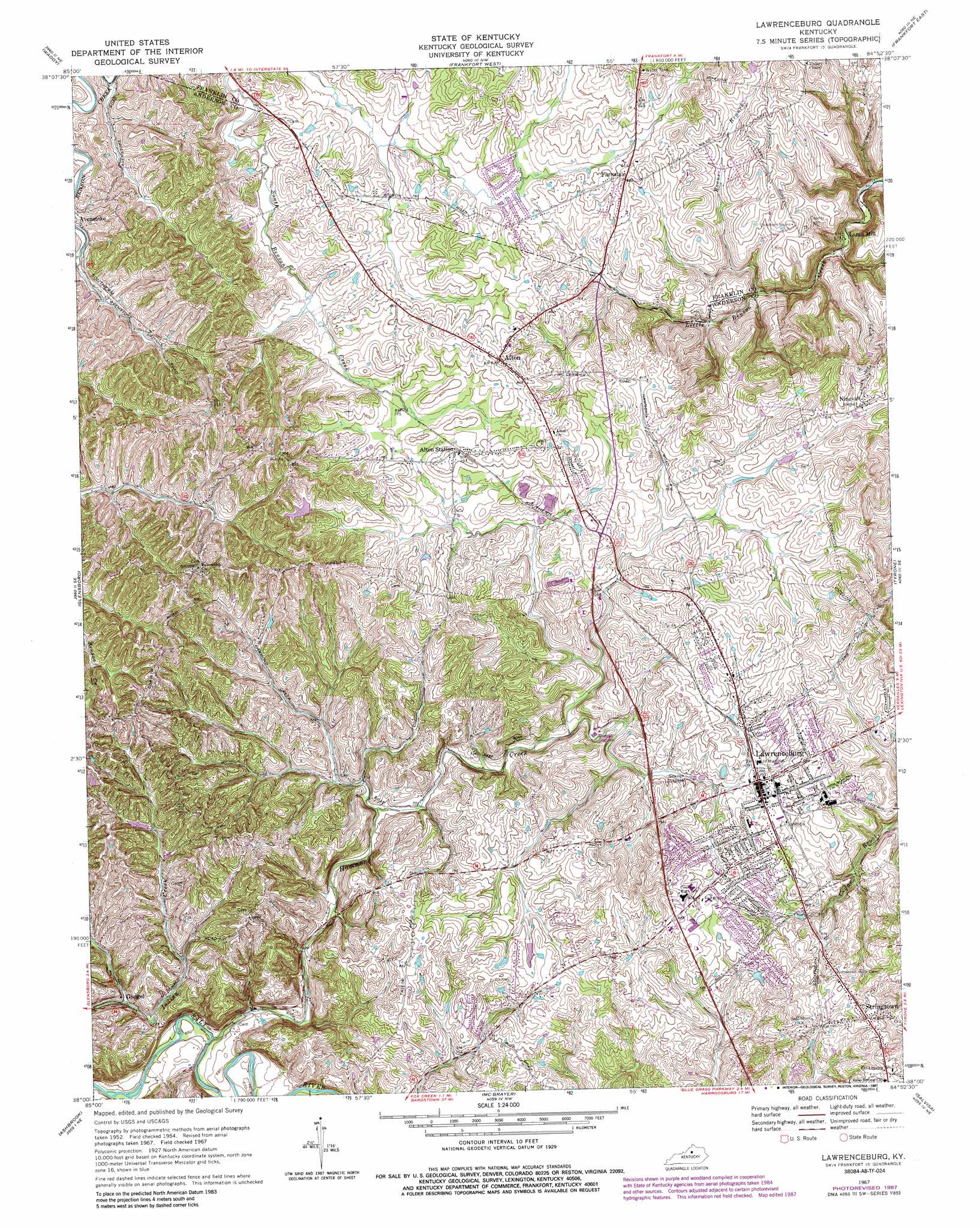
Lawrenceburg Topo Map Kentucky
To zoom in, hover over the map of Lawrenceburg
USGS Topo Quad 38084a8 - 1:24,000 scale
| Topo Map Name: | Lawrenceburg |
| USGS Topo Quad ID: | 38084a8 |
| Print Size: | ca. 21 1/4" wide x 27" high |
| Southeast Coordinates: | 38° N latitude / 84.875° W longitude |
| Map Center Coordinates: | 38.0625° N latitude / 84.9375° W longitude |
| U.S. State: | KY |
| Filename: | o38084a8.jpg |
| Download Map JPG Image: | Lawrenceburg topo map 1:24,000 scale |
| Map Type: | Topographic |
| Topo Series: | 7.5´ |
| Map Scale: | 1:24,000 |
| Source of Map Images: | United States Geological Survey (USGS) |
| Alternate Map Versions: |
Lawrenceburg KY 1951, updated 1961 Download PDF Buy paper map Lawrenceburg KY 1954, updated 1955 Download PDF Buy paper map Lawrenceburg KY 1954, updated 1965 Download PDF Buy paper map Lawrenceburg KY 1961, updated 1971 Download PDF Buy paper map Lawrenceburg KY 1967, updated 1970 Download PDF Buy paper map Lawrenceburg KY 1967, updated 1979 Download PDF Buy paper map Lawrenceburg KY 1967, updated 1987 Download PDF Buy paper map Alton Station KY 2010 Download PDF Buy paper map Alton Station KY 2013 Download PDF Buy paper map Alton Station KY 2016 Download PDF Buy paper map |
1:24,000 Topo Quads surrounding Lawrenceburg
Eminence |
North Pleasureville |
Polsgrove |
Switzer |
Stamping Ground |
Shelbyville |
Waddy |
Frankfort West |
Frankfort East |
Midway |
Mount Eden |
Glensboro |
Lawrenceburg |
Tyrone |
Versailles |
Chaplin |
Ashbrook |
Mcbrayer |
Salvisa |
Keene |
Brush Grove |
Cardwell |
Cornishville |
Harrodsburg |
Wilmore |
> Back to 38084a1 at 1:100,000 scale
> Back to 38084a1 at 1:250,000 scale
> Back to U.S. Topo Maps home
Lawrenceburg topo map: Gazetteer
Lawrenceburg: Populated Places
Alton elevation 256m 839′Alton Station elevation 245m 803′
Farmdale elevation 246m 807′
Lawrenceburg elevation 240m 787′
Ninevah elevation 256m 839′
Stringtown elevation 262m 859′
Lawrenceburg: Post Offices
Alton Post Office (historical) elevation 252m 826′Alton Station Post Office (historical) elevation 244m 800′
Farmdale Post Office (historical) elevation 254m 833′
Grafton Post Office (historical) elevation 209m 685′
Gudgel Post Office (historical) elevation 212m 695′
Nineveh Post Office (historical) elevation 258m 846′
Lawrenceburg: Springs
Arnold Spring (historical) elevation 224m 734′Lawrenceburg: Streams
Boone Branch elevation 192m 629′Hammond Creek elevation 198m 649′
Lawrenceburg digital topo map on disk
Buy this Lawrenceburg topo map showing relief, roads, GPS coordinates and other geographical features, as a high-resolution digital map file on DVD: