Gratz Topo Map Kentucky
To zoom in, hover over the map of Gratz
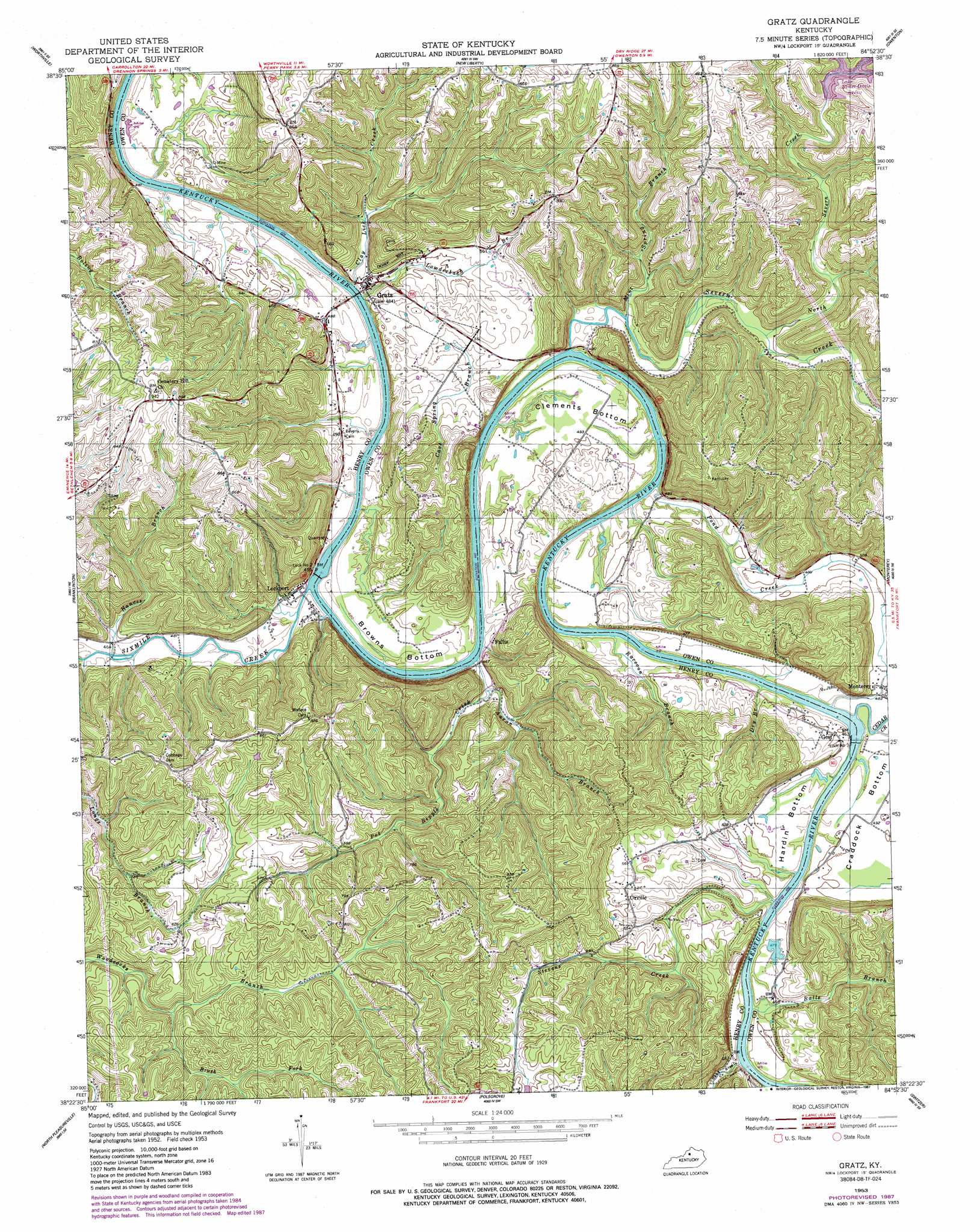
USGS Topo Quad 38084d8 - 1:24,000 scale
| Topo Map Name: | Gratz |
| USGS Topo Quad ID: | 38084d8 |
| Print Size: | ca. 21 1/4" wide x 27" high |
| Southeast Coordinates: | 38.375° N latitude / 84.875° W longitude |
| Map Center Coordinates: | 38.4375° N latitude / 84.9375° W longitude |
| U.S. State: | KY |
| Filename: | o38084d8.jpg |
| Download Map JPG Image: | Gratz topo map 1:24,000 scale |
| Map Type: | Topographic |
| Topo Series: | 7.5´ |
| Map Scale: | 1:24,000 |
| Source of Map Images: | United States Geological Survey (USGS) |
| Alternate Map Versions: |
Gratz KY 1953, updated 1954 Download PDF Buy paper map Gratz KY 1953, updated 1983 Download PDF Buy paper map Gratz KY 1953, updated 1987 Download PDF Buy paper map Gratz KY 2010 Download PDF Buy paper map Gratz KY 2013 Download PDF Buy paper map Gratz KY 2016 Download PDF Buy paper map |
1:24,000 Topo Quads surrounding Gratz
Carrollton |
Vevay South |
Sanders |
Glencoe |
Elliston |
Campbellsburg |
Worthville |
New Liberty |
Owenton |
Lawrenceville |
New Castle |
Franklinton |
Gratz |
Monterey |
New Columbus |
Eminence |
North Pleasureville |
Polsgrove |
Switzer |
Stamping Ground |
Shelbyville |
Waddy |
Frankfort West |
Frankfort East |
Midway |
> Back to 38084a1 at 1:100,000 scale
> Back to 38084a1 at 1:250,000 scale
> Back to U.S. Topo Maps home
Gratz topo map: Gazetteer
Gratz: Bends
Browns Bottom elevation 147m 482′Clements Bottom elevation 149m 488′
Craddock Bottom elevation 149m 488′
Hardin Bottom elevation 148m 485′
Gratz: Dams
Lock Number 2 elevation 134m 439′Lock Number 3 elevation 139m 456′
Gratz: Populated Places
Fallis elevation 162m 531′Gest elevation 150m 492′
Gratz elevation 137m 449′
Lockport elevation 144m 472′
Orville elevation 175m 574′
Gratz: Post Offices
Bar Post Office (historical) elevation 143m 469′Fallis Post Office (historical) elevation 140m 459′
Gest Post Office (historical) elevation 156m 511′
Gratz Post Office (historical) elevation 142m 465′
Lead Mines Post Office (historical) elevation 153m 501′
Lockport Post Office (historical) elevation 142m 465′
Mouth of Cedar Creek Post Office (historical) elevation 140m 459′
Noe Post Office (historical) elevation 278m 912′
Proverb Post Office (historical) elevation 141m 462′
Severn Creek Post Office (historical) elevation 150m 492′
Gratz: Streams
Aaron Branch elevation 139m 456′Balls Branch elevation 139m 456′
Bibbs Creek elevation 133m 436′
Brush Fork elevation 175m 574′
Cave Spring Branch elevation 165m 541′
Cedar Creek elevation 140m 459′
Clay Lick Creek elevation 143m 469′
Crooked Creek elevation 133m 436′
Dry Branch elevation 139m 456′
Hances Branch elevation 140m 459′
Lowderbach Branch elevation 137m 449′
Mill Wheel Branch elevation 140m 459′
Mint Spring Branch elevation 139m 456′
North Severn Creek elevation 151m 495′
Pond Creek elevation 150m 492′
Pot Ripple Creek elevation 143m 469′
Raccoon Branch elevation 137m 449′
Sand Ripple Creek elevation 138m 452′
Severn Creek elevation 142m 465′
Sixmile Creek elevation 137m 449′
Stevens Creek elevation 138m 452′
Gratz: Summits
Cemetery Hill elevation 288m 944′Gratz: Wells
Gratz Sulphur Well (historical) elevation 135m 442′Gratz digital topo map on disk
Buy this Gratz topo map showing relief, roads, GPS coordinates and other geographical features, as a high-resolution digital map file on DVD: