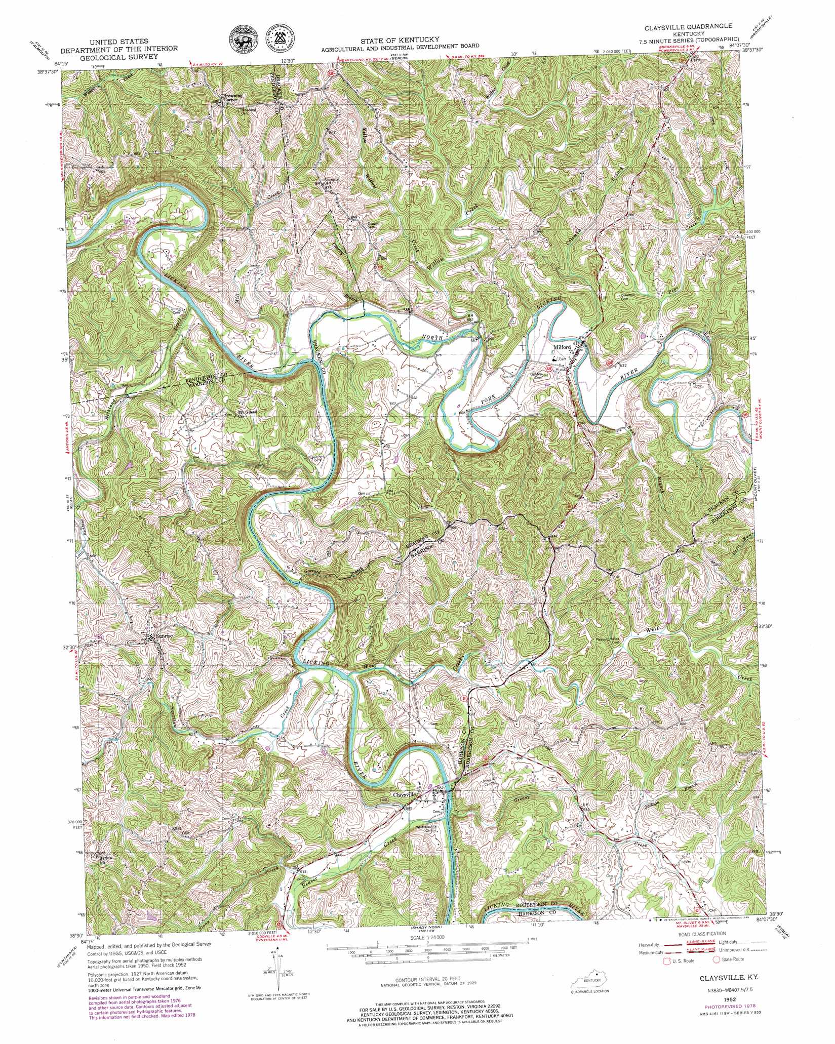
Claysville Topo Map Kentucky
To zoom in, hover over the map of Claysville
USGS Topo Quad 38084e2 - 1:24,000 scale
| Topo Map Name: | Claysville |
| USGS Topo Quad ID: | 38084e2 |
| Print Size: | ca. 21 1/4" wide x 27" high |
| Southeast Coordinates: | 38.5° N latitude / 84.125° W longitude |
| Map Center Coordinates: | 38.5625° N latitude / 84.1875° W longitude |
| U.S. State: | KY |
| Filename: | o38084e2.jpg |
| Download Map JPG Image: | Claysville topo map 1:24,000 scale |
| Map Type: | Topographic |
| Topo Series: | 7.5´ |
| Map Scale: | 1:24,000 |
| Source of Map Images: | United States Geological Survey (USGS) |
| Alternate Map Versions: |
Claysville KY 1952, updated 1954 Download PDF Buy paper map Claysville KY 1952, updated 1979 Download PDF Buy paper map Claysville KY 2010 Download PDF Buy paper map Claysville KY 2013 Download PDF Buy paper map Claysville KY 2016 Download PDF Buy paper map |
1:24,000 Topo Quads surrounding Claysville
De Mossville |
Butler |
Moscow |
Felicity |
Higginsport |
Goforth |
Falmouth |
Berlin |
Brooksville |
Germantown |
Berry |
Kelat |
Claysville |
Mount Olivet |
Sardis |
Breckinridge |
Cynthiana |
Shady Nook |
Piqua |
Cowan |
Leesburg |
Shawhan |
Millersburg |
Carlisle |
Moorefield |
> Back to 38084e1 at 1:100,000 scale
> Back to 38084a1 at 1:250,000 scale
> Back to U.S. Topo Maps home
Claysville topo map: Gazetteer
Claysville: Populated Places
Browning Corner elevation 275m 902′Claysville elevation 177m 580′
Milford elevation 185m 606′
Petra elevation 280m 918′
Sunrise elevation 249m 816′
Claysville: Post Offices
Aulick Post Office (historical) elevation 198m 649′Ernst Post Office (historical) elevation 175m 574′
Milford Post Office (historical) elevation 184m 603′
Travelers Rest Post Office (historical) elevation 184m 603′
Claysville: Streams
Beaver Creek elevation 171m 561′Charley Branch elevation 172m 564′
Coleman Branch elevation 181m 593′
Garrard Branch elevation 170m 557′
Greasy Creek elevation 171m 561′
Harrison Creek elevation 170m 557′
Jackson Branch elevation 204m 669′
Little Richland Creek elevation 196m 643′
Mill Creek elevation 170m 557′
North Fork Licking River elevation 170m 557′
Pipe Creek elevation 183m 600′
Richland Creek elevation 164m 538′
Rush Branch elevation 180m 590′
Stony Creek elevation 183m 600′
West Creek elevation 168m 551′
Willow Creek elevation 176m 577′
Yellow Willow Creek elevation 187m 613′
Claysville digital topo map on disk
Buy this Claysville topo map showing relief, roads, GPS coordinates and other geographical features, as a high-resolution digital map file on DVD: