Brooksville Topo Map Kentucky
To zoom in, hover over the map of Brooksville
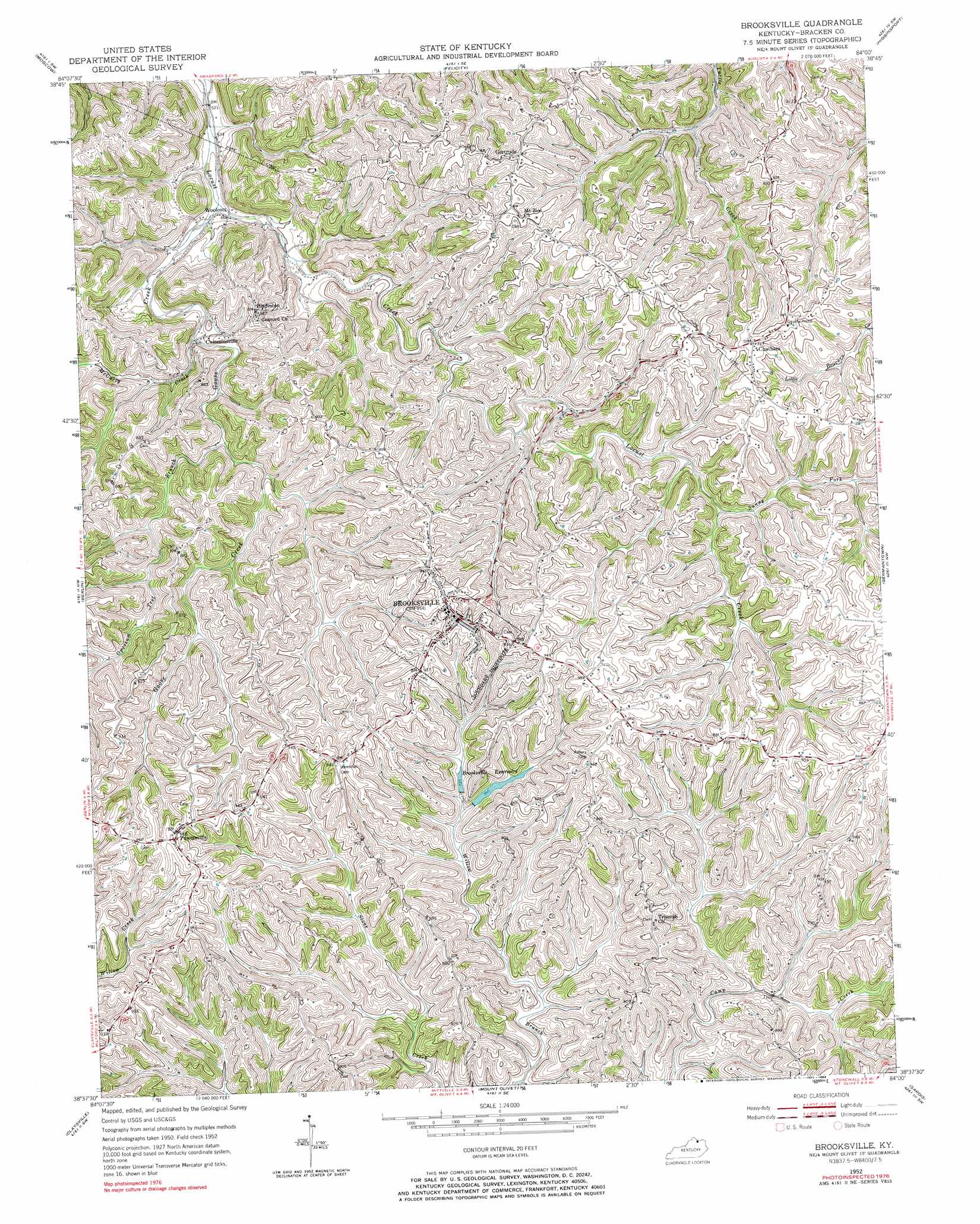
USGS Topo Quad 38084f1 - 1:24,000 scale
| Topo Map Name: | Brooksville |
| USGS Topo Quad ID: | 38084f1 |
| Print Size: | ca. 21 1/4" wide x 27" high |
| Southeast Coordinates: | 38.625° N latitude / 84° W longitude |
| Map Center Coordinates: | 38.6875° N latitude / 84.0625° W longitude |
| U.S. State: | KY |
| Filename: | o38084f1.jpg |
| Download Map JPG Image: | Brooksville topo map 1:24,000 scale |
| Map Type: | Topographic |
| Topo Series: | 7.5´ |
| Map Scale: | 1:24,000 |
| Source of Map Images: | United States Geological Survey (USGS) |
| Alternate Map Versions: |
Brooksville KY 1952, updated 1954 Download PDF Buy paper map Brooksville KY 1952, updated 1970 Download PDF Buy paper map Brooksville KY 1952, updated 1983 Download PDF Buy paper map Brooksville KY 2010 Download PDF Buy paper map Brooksville KY 2013 Download PDF Buy paper map Brooksville KY 2016 Download PDF Buy paper map |
1:24,000 Topo Quads surrounding Brooksville
New Richmond |
Laurel |
Bethel |
Hamersville |
Ash Ridge |
Butler |
Moscow |
Felicity |
Higginsport |
Russellville |
Falmouth |
Berlin |
Brooksville |
Germantown |
Maysville West |
Kelat |
Claysville |
Mount Olivet |
Sardis |
Mays Lick |
Cynthiana |
Shady Nook |
Piqua |
Cowan |
Elizaville |
> Back to 38084e1 at 1:100,000 scale
> Back to 38084a1 at 1:250,000 scale
> Back to U.S. Topo Maps home
Brooksville topo map: Gazetteer
Brooksville: Bridges
Walcott Covered Bridge elevation 169m 554′Brooksville: Populated Places
Asbury elevation 287m 941′Bladeston elevation 262m 859′
Brooksville elevation 285m 935′
Chatham elevation 285m 935′
Cumminsville elevation 208m 682′
Gertrude elevation 278m 912′
Parina (historical) elevation 269m 882′
Powersville elevation 295m 967′
Woolcott elevation 172m 564′
Brooksville: Post Offices
Bladeston Post Office (historical) elevation 264m 866′Chatham Post Office (historical) elevation 284m 931′
Gertrude Post Office (historical) elevation 277m 908′
Parina Post Office (historical) elevation 269m 882′
Powersville Post Office (historical) elevation 290m 951′
Brooksville: Reservoirs
Brooksville Reservoir elevation 220m 721′Brooksville: Streams
Goose Creek elevation 168m 551′McCarty Creek elevation 198m 649′
McKanes Run elevation 212m 695′
Norris Run elevation 202m 662′
Opossum Trot Branch elevation 210m 688′
Poe Creek elevation 207m 679′
Sunny Fork Locust Creek elevation 226m 741′
Wilcox Branch elevation 225m 738′
Brooksville digital topo map on disk
Buy this Brooksville topo map showing relief, roads, GPS coordinates and other geographical features, as a high-resolution digital map file on DVD: