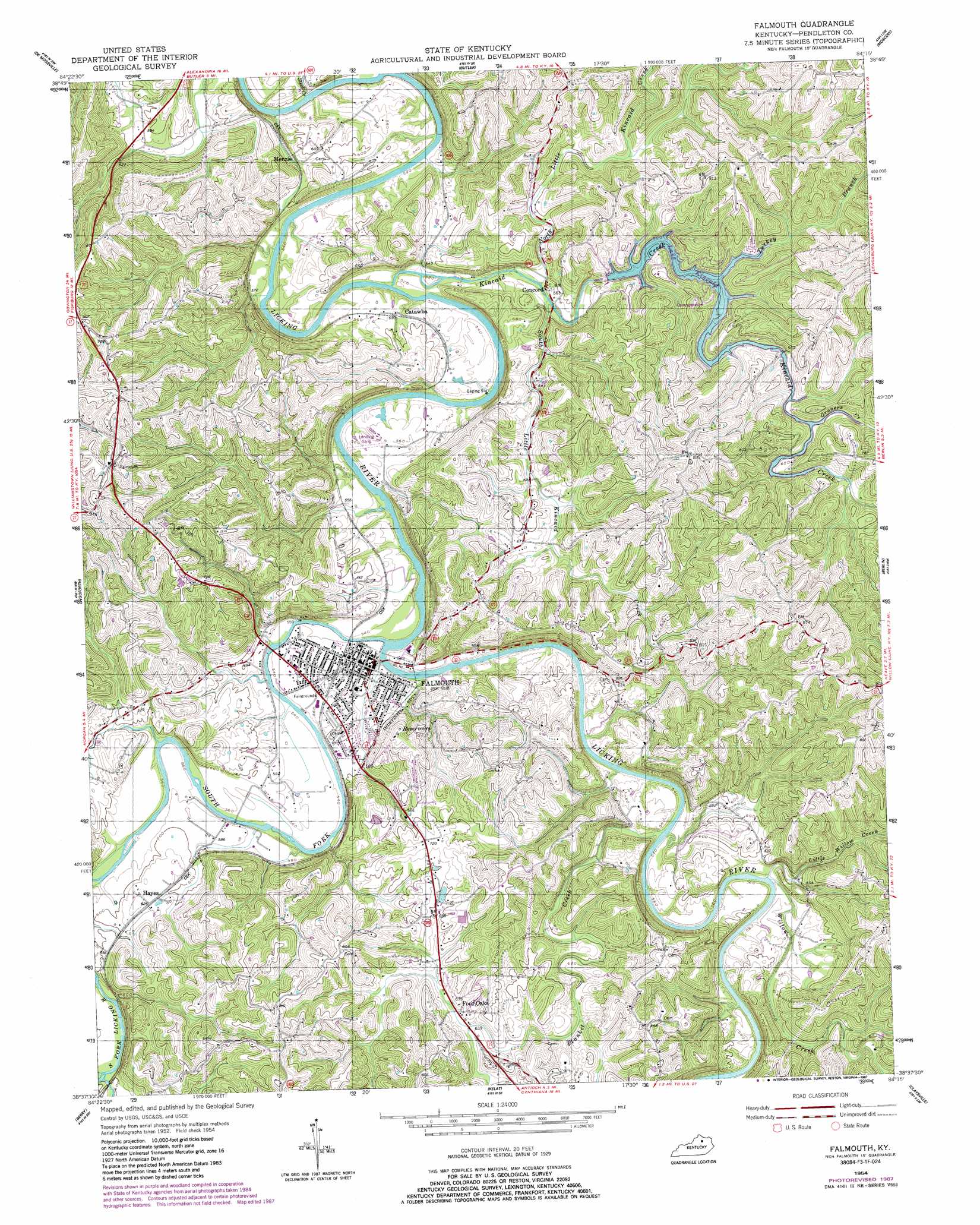
Falmouth Topo Map Kentucky
To zoom in, hover over the map of Falmouth
USGS Topo Quad 38084f3 - 1:24,000 scale
| Topo Map Name: | Falmouth |
| USGS Topo Quad ID: | 38084f3 |
| Print Size: | ca. 21 1/4" wide x 27" high |
| Southeast Coordinates: | 38.625° N latitude / 84.25° W longitude |
| Map Center Coordinates: | 38.6875° N latitude / 84.3125° W longitude |
| U.S. State: | KY |
| Filename: | o38084f3.jpg |
| Download Map JPG Image: | Falmouth topo map 1:24,000 scale |
| Map Type: | Topographic |
| Topo Series: | 7.5´ |
| Map Scale: | 1:24,000 |
| Source of Map Images: | United States Geological Survey (USGS) |
| Alternate Map Versions: |
Falmouth KY 1954, updated 1955 Download PDF Buy paper map Falmouth KY 1954, updated 1987 Download PDF Buy paper map Falmouth KY 2010 Download PDF Buy paper map Falmouth KY 2013 Download PDF Buy paper map Falmouth KY 2016 Download PDF Buy paper map |
1:24,000 Topo Quads surrounding Falmouth
Independence |
Alexandria |
New Richmond |
Laurel |
Bethel |
Walton |
De Mossville |
Butler |
Moscow |
Felicity |
Williamstown |
Goforth |
Falmouth |
Berlin |
Brooksville |
Mason |
Berry |
Kelat |
Claysville |
Mount Olivet |
Sadieville |
Breckinridge |
Cynthiana |
Shady Nook |
Piqua |
> Back to 38084e1 at 1:100,000 scale
> Back to 38084a1 at 1:250,000 scale
> Back to U.S. Topo Maps home
Falmouth topo map: Gazetteer
Falmouth: Airports
Rays Air Strip elevation 173m 567′Falmouth: Flats
Irving Bottom elevation 163m 534′Falmouth: Parks
Kincaid Lake State Park elevation 195m 639′Falmouth: Populated Places
Catawba elevation 177m 580′Concord elevation 171m 561′
Falmouth elevation 168m 551′
Four Oaks elevation 192m 629′
Hayes elevation 194m 636′
Menzie elevation 171m 561′
Falmouth: Post Offices
Catawba Post Office (historical) elevation 172m 564′Four Oaks Post Office (historical) elevation 197m 646′
Levingood Post Office (historical) elevation 194m 636′
Penshurst Post Office (historical) elevation 167m 547′
Wampum Post Office (historical) elevation 192m 629′
Wrights Station Post Office (historical) elevation 175m 574′
Falmouth: Reservoirs
Kincaid Lake elevation 177m 580′Falmouth: Streams
Blanket Creek elevation 163m 534′Grovers Creek elevation 184m 603′
Johnson Creek elevation 172m 564′
Kincaid Creek elevation 158m 518′
Little Willow Creek elevation 164m 538′
North Little Kincaid Creek elevation 163m 534′
South Fork Licking River elevation 157m 515′
South Little Kincaid Creek elevation 167m 547′
Steel Creek elevation 150m 492′
Steer Creek elevation 151m 495′
Turkey Branch elevation 184m 603′
Willow Creek elevation 164m 538′
Falmouth: Summits
Reservoir Hill elevation 233m 764′Thomas Hill elevation 276m 905′
Falmouth digital topo map on disk
Buy this Falmouth topo map showing relief, roads, GPS coordinates and other geographical features, as a high-resolution digital map file on DVD: