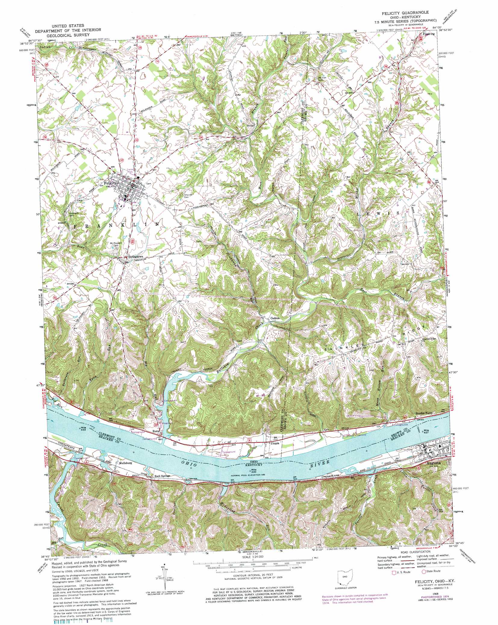
Felicity Topo Map Ohio
To zoom in, hover over the map of Felicity
USGS Topo Quad 38084g1 - 1:24,000 scale
| Topo Map Name: | Felicity |
| USGS Topo Quad ID: | 38084g1 |
| Print Size: | ca. 21 1/4" wide x 27" high |
| Southeast Coordinates: | 38.75° N latitude / 84° W longitude |
| Map Center Coordinates: | 38.8125° N latitude / 84.0625° W longitude |
| U.S. States: | OH, KY |
| Filename: | o38084g1.jpg |
| Download Map JPG Image: | Felicity topo map 1:24,000 scale |
| Map Type: | Topographic |
| Topo Series: | 7.5´ |
| Map Scale: | 1:24,000 |
| Source of Map Images: | United States Geological Survey (USGS) |
| Alternate Map Versions: |
Felicity OH 1953, updated 1955 Download PDF Buy paper map Felicity OH 1953, updated 1967 Download PDF Buy paper map Felicity OH 1968, updated 1970 Download PDF Buy paper map Felicity OH 1968, updated 1976 Download PDF Buy paper map Felicity OH 2010 Download PDF Buy paper map Felicity OH 2013 Download PDF Buy paper map Felicity OH 2016 Download PDF Buy paper map |
1:24,000 Topo Quads surrounding Felicity
Withamsville |
Batavia |
Williamsburg |
Mount Orab |
Sardinia |
New Richmond |
Laurel |
Bethel |
Hamersville |
Ash Ridge |
Butler |
Moscow |
Felicity |
Higginsport |
Russellville |
Falmouth |
Berlin |
Brooksville |
Germantown |
Maysville West |
Kelat |
Claysville |
Mount Olivet |
Sardis |
Mays Lick |
> Back to 38084e1 at 1:100,000 scale
> Back to 38084a1 at 1:250,000 scale
> Back to U.S. Topo Maps home
Felicity topo map: Gazetteer
Felicity: Bars
Augusta Bar elevation 147m 482′Felicity: Crossings
Boudes Ferry elevation 152m 498′Felicity: Populated Places
Augusta elevation 157m 515′Cedron elevation 165m 541′
Felicity elevation 280m 918′
Rock Springs elevation 172m 564′
Rural elevation 151m 495′
Stringtown elevation 269m 882′
Utopia elevation 151m 495′
Wellsburg elevation 153m 501′
Felicity: Post Offices
Cedron Post Office (historical) elevation 165m 541′Elmgrove Post Office (historical) elevation 156m 511′
Felicity Post Office elevation 280m 918′
Rural Post Office (historical) elevation 149m 488′
Tietzville Post Office (historical) elevation 157m 515′
Utopia Post Office (historical) elevation 152m 498′
Felicity: Streams
Big Run elevation 150m 492′Big Run elevation 152m 498′
Bullskin Creek elevation 145m 475′
Chalfant Creek elevation 152m 498′
Crooked Run elevation 151m 495′
East Branch Bullskin Creek elevation 175m 574′
Little Turtle Creek elevation 151m 495′
Locust Creek elevation 152m 498′
Middle Branch Bullskin Creek elevation 183m 600′
Moon Hollow Run elevation 151m 495′
Painter Fork elevation 232m 761′
Patterson Run elevation 152m 498′
Ryan Run elevation 152m 498′
Slickaway Run elevation 165m 541′
Turtle Creek elevation 152m 498′
West Branch Bullskin Creek elevation 200m 656′
Wrangling Run elevation 152m 498′
Felicity digital topo map on disk
Buy this Felicity topo map showing relief, roads, GPS coordinates and other geographical features, as a high-resolution digital map file on DVD: