Walton Topo Map Kentucky
To zoom in, hover over the map of Walton
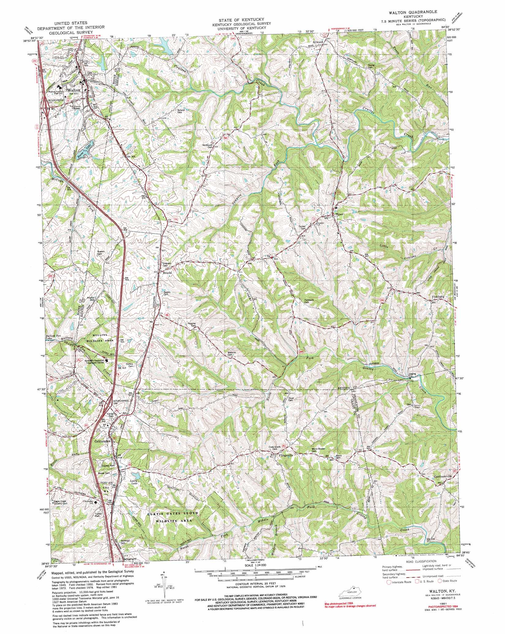
USGS Topo Quad 38084g5 - 1:24,000 scale
| Topo Map Name: | Walton |
| USGS Topo Quad ID: | 38084g5 |
| Print Size: | ca. 21 1/4" wide x 27" high |
| Southeast Coordinates: | 38.75° N latitude / 84.5° W longitude |
| Map Center Coordinates: | 38.8125° N latitude / 84.5625° W longitude |
| U.S. State: | KY |
| Filename: | o38084g5.jpg |
| Download Map JPG Image: | Walton topo map 1:24,000 scale |
| Map Type: | Topographic |
| Topo Series: | 7.5´ |
| Map Scale: | 1:24,000 |
| Source of Map Images: | United States Geological Survey (USGS) |
| Alternate Map Versions: |
Walton KY 1950, updated 1952 Download PDF Buy paper map Walton KY 1961, updated 1962 Download PDF Buy paper map Walton KY 1961, updated 1976 Download PDF Buy paper map Walton KY 1981, updated 1982 Download PDF Buy paper map Walton KY 1981, updated 1991 Download PDF Buy paper map Walton KY 2010 Download PDF Buy paper map Walton KY 2013 Download PDF Buy paper map Walton KY 2016 Download PDF Buy paper map |
1:24,000 Topo Quads surrounding Walton
Lawrenceburg |
Burlington |
Covington |
Newport |
Withamsville |
Rising Sun |
Union |
Independence |
Alexandria |
New Richmond |
Patriot |
Verona |
Walton |
De Mossville |
Butler |
Glencoe |
Elliston |
Williamstown |
Goforth |
Falmouth |
Owenton |
Lawrenceville |
Mason |
Berry |
Kelat |
> Back to 38084e1 at 1:100,000 scale
> Back to 38084a1 at 1:250,000 scale
> Back to U.S. Topo Maps home
Walton topo map: Gazetteer
Walton: Parks
Mullins Wildlife Area elevation 274m 898′Walton Woods Park elevation 268m 879′
Walton: Populated Places
Atwood elevation 270m 885′Bracht elevation 280m 918′
Crittenden elevation 284m 931′
Fiskburg elevation 269m 882′
Flingsville elevation 267m 875′
Gardnersville elevation 269m 882′
Piner elevation 276m 905′
Walton: Post Offices
Atwood Post Office (historical) elevation 269m 882′Fiskburgh Post Office (historical) elevation 271m 889′
Gaines Post Office (historical) elevation 281m 921′
Gardnersville Post Office (historical) elevation 264m 866′
Key West Post Office (historical) elevation 283m 928′
Piner Post Office (historical) elevation 274m 898′
Walton: Reservoirs
Boone Lake elevation 250m 820′Walton: Streams
Sawyers Fork elevation 208m 682′Wildcat Branch elevation 213m 698′
Walton digital topo map on disk
Buy this Walton topo map showing relief, roads, GPS coordinates and other geographical features, as a high-resolution digital map file on DVD: