Laurel Topo Map Ohio
To zoom in, hover over the map of Laurel
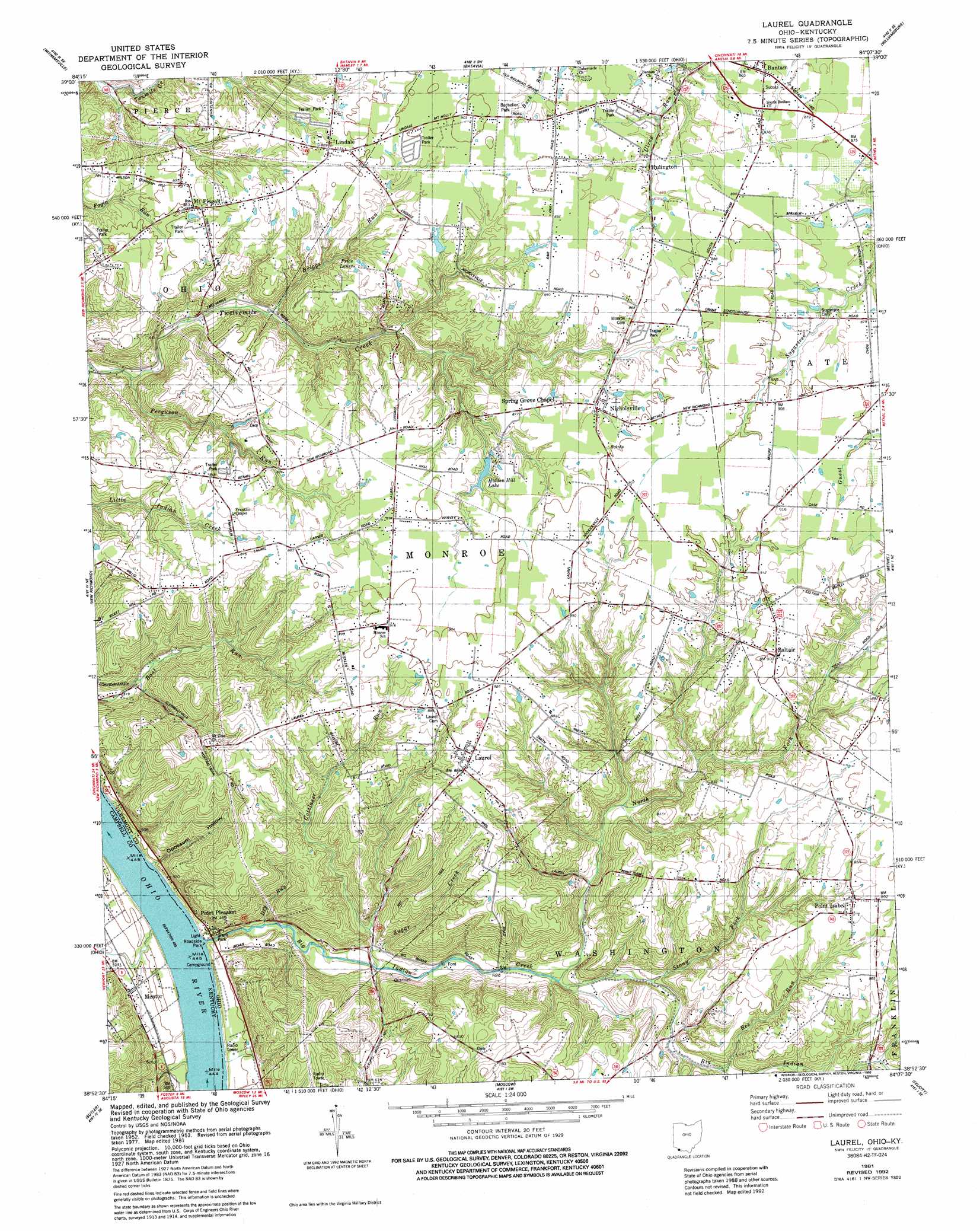
USGS Topo Quad 38084h2 - 1:24,000 scale
| Topo Map Name: | Laurel |
| USGS Topo Quad ID: | 38084h2 |
| Print Size: | ca. 21 1/4" wide x 27" high |
| Southeast Coordinates: | 38.875° N latitude / 84.125° W longitude |
| Map Center Coordinates: | 38.9375° N latitude / 84.1875° W longitude |
| U.S. States: | OH, KY |
| Filename: | o38084h2.jpg |
| Download Map JPG Image: | Laurel topo map 1:24,000 scale |
| Map Type: | Topographic |
| Topo Series: | 7.5´ |
| Map Scale: | 1:24,000 |
| Source of Map Images: | United States Geological Survey (USGS) |
| Alternate Map Versions: |
Laurel OH 1953, updated 1955 Download PDF Buy paper map Laurel OH 1968, updated 1970 Download PDF Buy paper map Laurel OH 1968, updated 1975 Download PDF Buy paper map Laurel OH 1981, updated 1982 Download PDF Buy paper map Laurel OH 1981, updated 1992 Download PDF Buy paper map Laurel OH 2010 Download PDF Buy paper map Laurel OH 2013 Download PDF Buy paper map Laurel OH 2016 Download PDF Buy paper map |
1:24,000 Topo Quads surrounding Laurel
Cincinnati East |
Madeira |
Goshen |
Newtonsville |
Fayetteville |
Newport |
Withamsville |
Batavia |
Williamsburg |
Mount Orab |
Alexandria |
New Richmond |
Laurel |
Bethel |
Hamersville |
De Mossville |
Butler |
Moscow |
Felicity |
Higginsport |
Goforth |
Falmouth |
Berlin |
Brooksville |
Germantown |
> Back to 38084e1 at 1:100,000 scale
> Back to 38084a1 at 1:250,000 scale
> Back to U.S. Topo Maps home
Laurel topo map: Gazetteer
Laurel: Dams
Goldman Pond Dam elevation 265m 869′Laurel: Harbors
Frontier Boat Harbor elevation 139m 456′Laurel: Lakes
Price Lakes elevation 262m 859′Laurel: Parks
Bachelier Park elevation 270m 885′Grant Park elevation 143m 469′
Ohio Township Park elevation 250m 820′
Laurel: Populated Places
Bantam elevation 263m 862′Fair Oak (historical) elevation 268m 879′
Hulington elevation 263m 862′
Laurel elevation 269m 882′
Lindale elevation 271m 889′
Mentor elevation 160m 524′
Mount Pisgah elevation 249m 816′
Nicholsville elevation 266m 872′
Point Isabel elevation 268m 879′
Point Pleasant elevation 149m 488′
Saltair elevation 275m 902′
South Bantam elevation 271m 889′
Laurel: Post Offices
Bantam Post Office (historical) elevation 263m 862′Hulington Post Office (historical) elevation 263m 862′
Kennedys Ferry Post Office (historical) elevation 148m 485′
Laurel Post Office (historical) elevation 269m 882′
Lindale Post Office (historical) elevation 271m 889′
Mentor Post Office (historical) elevation 152m 498′
Mount Pisgah Post Office (historical) elevation 250m 820′
Nicholsville Post Office (historical) elevation 266m 872′
Point Isabel Post Office (historical) elevation 268m 879′
Point Pleasant Post Office elevation 152m 498′
Laurel: Reservoirs
Goldman Pond elevation 265m 869′Hidden Hill Lake elevation 262m 859′
Meadow Lake elevation 247m 810′
Roberts Lake elevation 261m 856′
Spanaway Lake elevation 250m 820′
Laurel: Streams
Bee Run elevation 200m 656′Big Indian Creek elevation 138m 452′
Briggs Run elevation 195m 639′
Busses Run elevation 142m 465′
Colclaser Run elevation 147m 482′
Dry Run elevation 145m 475′
Ferguson Run elevation 174m 570′
North Fork Indian Creek elevation 163m 534′
Stony Fork elevation 163m 534′
Sugar Creek elevation 154m 505′
Laurel: Valleys
Opossum Hollow elevation 154m 505′Laurel digital topo map on disk
Buy this Laurel topo map showing relief, roads, GPS coordinates and other geographical features, as a high-resolution digital map file on DVD: