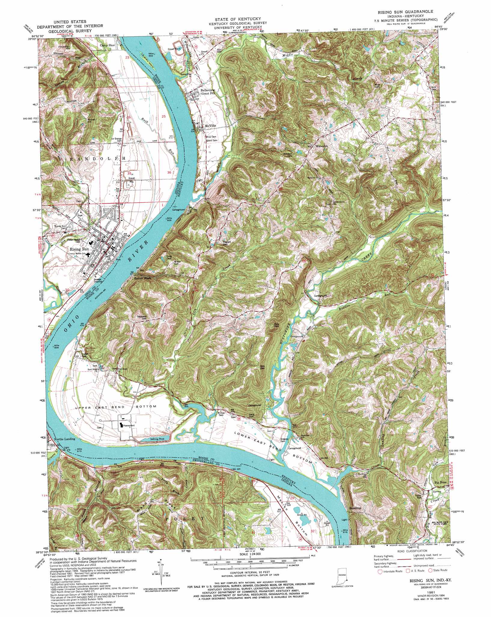
Rising Sun Topo Map Kentucky
To zoom in, hover over the map of Rising Sun
USGS Topo Quad 38084h7 - 1:24,000 scale
| Topo Map Name: | Rising Sun |
| USGS Topo Quad ID: | 38084h7 |
| Print Size: | ca. 21 1/4" wide x 27" high |
| Southeast Coordinates: | 38.875° N latitude / 84.75° W longitude |
| Map Center Coordinates: | 38.9375° N latitude / 84.8125° W longitude |
| U.S. States: | KY, IN |
| Filename: | o38084h7.jpg |
| Download Map JPG Image: | Rising Sun topo map 1:24,000 scale |
| Map Type: | Topographic |
| Topo Series: | 7.5´ |
| Map Scale: | 1:24,000 |
| Source of Map Images: | United States Geological Survey (USGS) |
| Alternate Map Versions: |
Rising Sun IN 1943 Download PDF Buy paper map Rising Sun IN 1951, updated 1953 Download PDF Buy paper map Rising Sun IN 1961, updated 1963 Download PDF Buy paper map Rising Sun IN 1961, updated 1973 Download PDF Buy paper map Rising Sun IN 1981, updated 1982 Download PDF Buy paper map Rising Sun IN 1981, updated 1984 Download PDF Buy paper map Rising Sun IN 1981, updated 1994 Download PDF Buy paper map Rising Sun IN 2010 Download PDF Buy paper map Rising Sun IN 2013 Download PDF Buy paper map Rising Sun IN 2016 Download PDF Buy paper map |
1:24,000 Topo Quads surrounding Rising Sun
Sunman |
Guilford |
Hooven |
Addyston |
Cincinnati West |
Dillsboro |
Aurora |
Lawrenceburg |
Burlington |
Covington |
Bear Branch |
Aberdeen |
Rising Sun |
Union |
Independence |
Vevay North |
Florence |
Patriot |
Verona |
Walton |
Vevay South |
Sanders |
Glencoe |
Elliston |
Williamstown |
> Back to 38084e1 at 1:100,000 scale
> Back to 38084a1 at 1:250,000 scale
> Back to U.S. Topo Maps home
Rising Sun topo map: Gazetteer
Rising Sun: Bends
Lower East Bend Bottom elevation 141m 462′Mexico Bottom elevation 160m 524′
Upper East Bend Bottom elevation 162m 531′
Rising Sun: Islands
Laughery Island elevation 138m 452′Rising Sun: Parks
Big Bone Lick State Park elevation 143m 469′Rising Sun: Populated Places
Belleview elevation 155m 508′Big Bone elevation 151m 495′
Camp Shor elevation 144m 472′
Hamilton elevation 148m 485′
McVille elevation 155m 508′
Norths Landing elevation 145m 475′
Rabbit Hash elevation 153m 501′
Rising Sun elevation 153m 501′
Waterloo elevation 259m 849′
Rising Sun: Post Offices
Bigbone Post Office (historical) elevation 152m 498′Boones Post Office (historical) elevation 180m 590′
East Bend Post Office (historical) elevation 156m 511′
Grant Post Office (historical) elevation 154m 505′
Piatts Landing Post Office (historical) elevation 142m 465′
Rabbit Hash Post Office (historical) elevation 145m 475′
Rising Sun: Ridges
Mead Ridge elevation 266m 872′Rising Sun: Springs
Big Bone Lick elevation 143m 469′Rising Sun: Streams
Buck Run elevation 139m 456′DeHart Creek elevation 140m 459′
Dry Brook elevation 141m 462′
Forty Wink Creek elevation 140m 459′
Grants Creek elevation 140m 459′
Gum Branch elevation 140m 459′
Gunpowder Creek elevation 137m 449′
Gunpowder Creek elevation 137m 449′
Landing Creek elevation 137m 449′
Lick Creek elevation 139m 456′
Long Branch elevation 196m 643′
Middle Creek elevation 137m 449′
North Branch elevation 143m 469′
Riddles Run elevation 141m 462′
Willoughby Creek elevation 140m 459′
Rising Sun: Summits
Henschen Hill elevation 248m 813′Indian Hill elevation 230m 754′
Powell Hill elevation 247m 810′
Rising Sun: Valleys
Bogus Hollow elevation 162m 531′Rising Sun digital topo map on disk
Buy this Rising Sun topo map showing relief, roads, GPS coordinates and other geographical features, as a high-resolution digital map file on DVD: