Waddy Topo Map Kentucky
To zoom in, hover over the map of Waddy
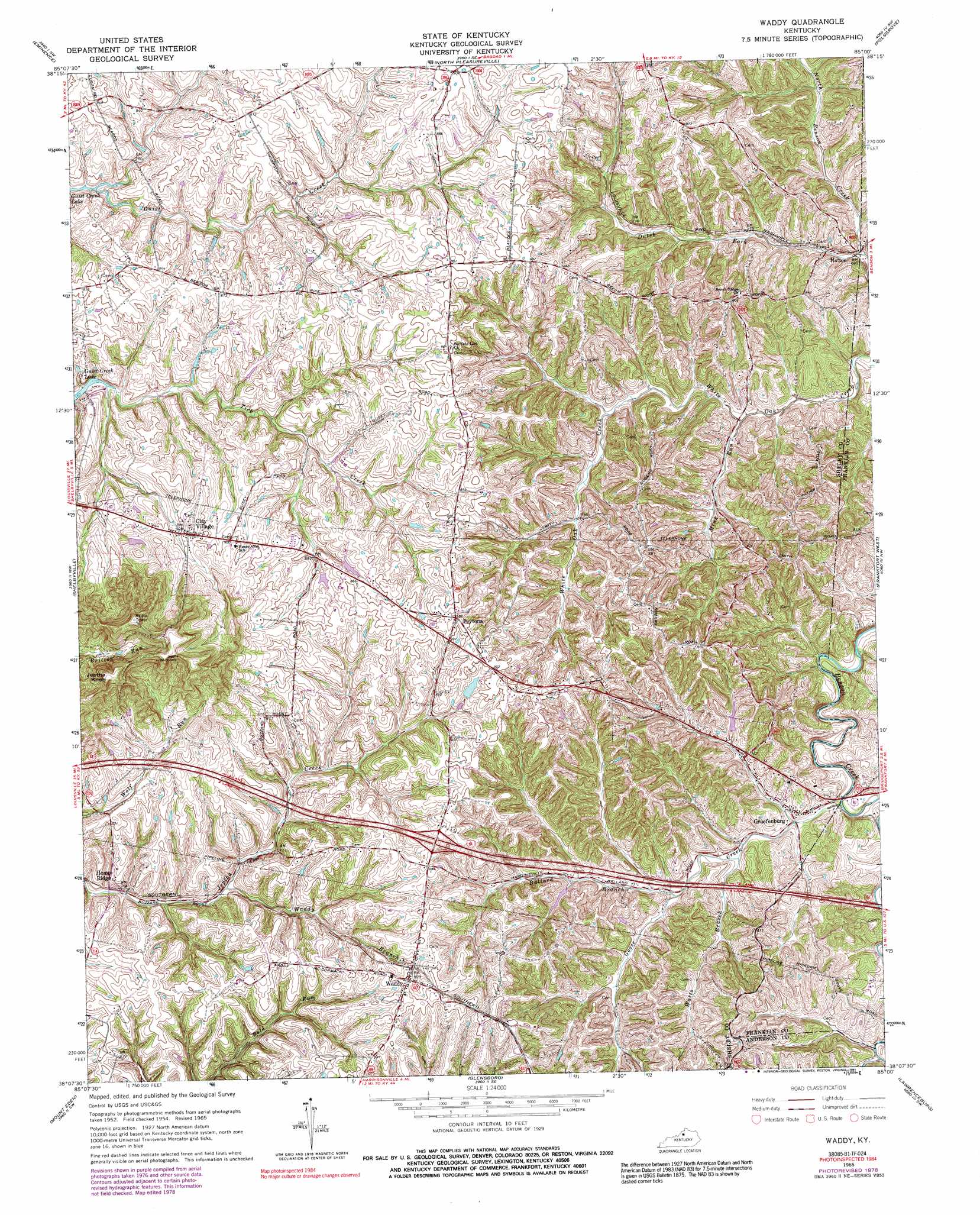
USGS Topo Quad 38085b1 - 1:24,000 scale
| Topo Map Name: | Waddy |
| USGS Topo Quad ID: | 38085b1 |
| Print Size: | ca. 21 1/4" wide x 27" high |
| Southeast Coordinates: | 38.125° N latitude / 85° W longitude |
| Map Center Coordinates: | 38.1875° N latitude / 85.0625° W longitude |
| U.S. State: | KY |
| Filename: | o38085b1.jpg |
| Download Map JPG Image: | Waddy topo map 1:24,000 scale |
| Map Type: | Topographic |
| Topo Series: | 7.5´ |
| Map Scale: | 1:24,000 |
| Source of Map Images: | United States Geological Survey (USGS) |
| Alternate Map Versions: |
Waddy KY 1954, updated 1955 Download PDF Buy paper map Waddy KY 1965, updated 1967 Download PDF Buy paper map Waddy KY 1965, updated 1976 Download PDF Buy paper map Waddy KY 1965, updated 1979 Download PDF Buy paper map Waddy KY 1965, updated 1991 Download PDF Buy paper map Waddy KY 2010 Download PDF Buy paper map Waddy KY 2013 Download PDF Buy paper map Waddy KY 2016 Download PDF Buy paper map |
1:24,000 Topo Quads surrounding Waddy
Smithfield |
New Castle |
Franklinton |
Gratz |
Monterey |
Ballardsville |
Eminence |
North Pleasureville |
Polsgrove |
Switzer |
Simpsonville |
Shelbyville |
Waddy |
Frankfort West |
Frankfort East |
Taylorsville |
Mount Eden |
Glensboro |
Lawrenceburg |
Tyrone |
Bloomfield |
Chaplin |
Ashbrook |
Mcbrayer |
Salvisa |
> Back to 38085a1 at 1:100,000 scale
> Back to 38084a1 at 1:250,000 scale
> Back to U.S. Topo Maps home
Waddy topo map: Gazetteer
Waddy: Airports
Hemp Ridge Airport elevation 255m 836′Waddy: Populated Places
Clay Village elevation 277m 908′Gibbs Road (historical) elevation 267m 875′
Graefenburg elevation 218m 715′
Hatton elevation 210m 688′
Hemp Ridge elevation 222m 728′
Peytona elevation 257m 843′
Roberts (historical) elevation 245m 803′
Waddy elevation 275m 902′
Waddy: Post Offices
Clay Village Post Office (historical) elevation 282m 925′Hatton Post Office (historical) elevation 213m 698′
Hempridge Post Office (historical) elevation 244m 800′
Lawrence Post Office (historical) elevation 276m 905′
Peytona Post Office (historical) elevation 279m 915′
Waddy: Streams
Ballard Branch elevation 219m 718′Bethel Branch elevation 234m 767′
Dutch Fork elevation 207m 679′
Goose Creek elevation 214m 702′
Mink Run elevation 223m 731′
Waddy Branch elevation 226m 741′
Watts Branch elevation 219m 718′
Waddy: Summits
Jeptha Knob elevation 360m 1181′Jeptha Knob elevation 361m 1184′
Waddy digital topo map on disk
Buy this Waddy topo map showing relief, roads, GPS coordinates and other geographical features, as a high-resolution digital map file on DVD: