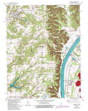
Lanesville Topo Map Indiana
To zoom in, hover over the map of Lanesville
USGS Topo Quad 38085b8 - 1:24,000 scale
| Topo Map Name: | Lanesville |
| USGS Topo Quad ID: | 38085b8 |
| Print Size: | ca. 21 1/4" wide x 27" high |
| Southeast Coordinates: | 38.125° N latitude / 85.875° W longitude |
| Map Center Coordinates: | 38.1875° N latitude / 85.9375° W longitude |
| U.S. States: | IN, KY |
| Filename: | o38085b8.jpg |
| Download Map JPG Image: | Lanesville topo map 1:24,000 scale |
| Map Type: | Topographic |
| Topo Series: | 7.5´ |
| Map Scale: | 1:24,000 |
| Source of Map Images: | United States Geological Survey (USGS) |
| Alternate Map Versions: |
Lanesville IN 1951 Download PDF Buy paper map Lanesville IN 1955, updated 1956 Download PDF Buy paper map Lanesville IN 1960, updated 1961 Download PDF Buy paper map Lanesville IN 1960, updated 1967 Download PDF Buy paper map Lanesville IN 1982, updated 1982 Download PDF Buy paper map Lanesville IN 1982, updated 1987 Download PDF Buy paper map Lanesville IN 1985, updated 1993 Download PDF Buy paper map Lanesville IN 2010 Download PDF Buy paper map Lanesville IN 2013 Download PDF Buy paper map Lanesville IN 2016 Download PDF Buy paper map |
1:24,000 Topo Quads surrounding Lanesville
> Back to 38085a1 at 1:100,000 scale
> Back to 38084a1 at 1:250,000 scale
> Back to U.S. Topo Maps home
Lanesville topo map: Gazetteer
Lanesville: Airports
Lanesville Skyways Airport elevation 266m 872′Lanesville: Canals
Garrison Ditch elevation 134m 439′Lanesville: Cliffs
Blunk Point elevation 242m 793′Bours Points elevation 241m 790′
Hellmans Point elevation 236m 774′
Vault Point elevation 262m 859′
Lanesville: Dams
Lanesville Reservoir Dam elevation 235m 770′Lutheran Laymans League Lake Dam elevation 235m 770′
Pine Springs Lake Dam elevation 234m 767′
Seven Springs Lake Dam elevation 211m 692′
Lanesville: Lakes
Arrowhead Lake elevation 131m 429′Lanesville: Populated Places
Bridgeport elevation 131m 429′Buchanan elevation 134m 439′
Greenwood elevation 137m 449′
Lanesville elevation 213m 698′
Locust Point elevation 139m 456′
Lottick Corner elevation 256m 839′
Salina elevation 132m 433′
Seven Springs elevation 216m 708′
Lanesville: Reservoirs
Lutheran Laymans League Lake elevation 235m 770′Pine Springs Lake elevation 234m 767′
Lanesville: Ridges
Backbone Ridge elevation 239m 784′Brock Ridge elevation 245m 803′
Huckleberry Ridge elevation 194m 636′
New Gunn Ridge elevation 252m 826′
Riley Ridge elevation 282m 925′
Rock House Ridge elevation 255m 836′
Sampson Ridge elevation 248m 813′
Schoolhouse Ridge elevation 257m 843′
Lanesville: Streams
Black Creek elevation 210m 688′Knob Creek elevation 117m 383′
Lazy Creek elevation 207m 679′
Little Indian Creek elevation 227m 744′
Mill Creek Cutoff elevation 119m 390′
Smith Creek elevation 218m 715′
Union Creek elevation 222m 728′
Woertz Creek elevation 215m 705′
Lanesville: Summits
Hickman Hill elevation 302m 990′Pickle Pear Knob elevation 233m 764′
Pigeon Roost elevation 227m 744′
Lanesville: Valleys
Deer Corner elevation 138m 452′Eiseman Hollow elevation 134m 439′
Sampson Hollow elevation 134m 439′
Stewart Hollow elevation 127m 416′
Lanesville digital topo map on disk
Buy this Lanesville topo map showing relief, roads, GPS coordinates and other geographical features, as a high-resolution digital map file on DVD:


