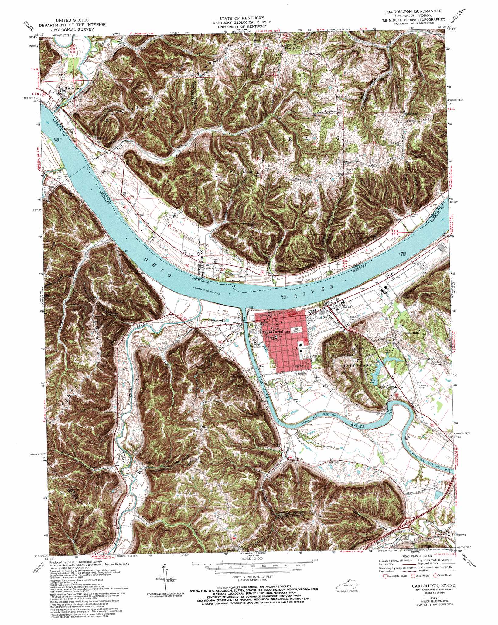
Carrollton Topo Map Kentucky
To zoom in, hover over the map of Carrollton
USGS Topo Quad 38085f2 - 1:24,000 scale
| Topo Map Name: | Carrollton |
| USGS Topo Quad ID: | 38085f2 |
| Print Size: | ca. 21 1/4" wide x 27" high |
| Southeast Coordinates: | 38.625° N latitude / 85.125° W longitude |
| Map Center Coordinates: | 38.6875° N latitude / 85.1875° W longitude |
| U.S. States: | KY, IN |
| Filename: | o38085f2.jpg |
| Download Map JPG Image: | Carrollton topo map 1:24,000 scale |
| Map Type: | Topographic |
| Topo Series: | 7.5´ |
| Map Scale: | 1:24,000 |
| Source of Map Images: | United States Geological Survey (USGS) |
| Alternate Map Versions: |
Brooksburg KY 1943 Download PDF Buy paper map Carrollton KY 1953, updated 1954 Download PDF Buy paper map Carrollton KY 1953, updated 1966 Download PDF Buy paper map Carrollton KY 1967, updated 1970 Download PDF Buy paper map Carrollton KY 1967, updated 1976 Download PDF Buy paper map Carrollton KY 1967, updated 1988 Download PDF Buy paper map Carrollton KY 1967, updated 1994 Download PDF Buy paper map Carrollton KY 2010 Download PDF Buy paper map Carrollton KY 2013 Download PDF Buy paper map Carrollton KY 2016 Download PDF Buy paper map |
1:24,000 Topo Quads surrounding Carrollton
San Jacinto |
Rexville |
Cross Plains |
Bear Branch |
Aberdeen |
Clifty Falls |
Canaan |
Bennington |
Vevay North |
Florence |
Madison West |
Madison East |
Carrollton |
Vevay South |
Sanders |
Bethlehem |
Bedford |
Campbellsburg |
Worthville |
New Liberty |
La Grange |
Smithfield |
New Castle |
Franklinton |
Gratz |
> Back to 38085e1 at 1:100,000 scale
> Back to 38084a1 at 1:250,000 scale
> Back to U.S. Topo Maps home
Carrollton topo map: Gazetteer
Carrollton: Airports
Robinson Airport elevation 147m 482′Carrollton: Bridges
Locust Bridge elevation 132m 433′Carrollton: Crossings
Prestons Ferry (historical) elevation 134m 439′Wickliffe Ferry (historical) elevation 132m 433′
Carrollton: Dams
Lock Number 1 elevation 132m 433′Carrollton: Parks
General Butler State Park elevation 215m 705′Carrollton: Populated Places
Braytown elevation 269m 882′Brooksburg elevation 144m 472′
Carrollton elevation 147m 482′
English elevation 145m 475′
Five Points elevation 267m 875′
Indian Hills elevation 151m 495′
Lamb elevation 147m 482′
Mound Hill (historical) elevation 150m 492′
Prestonville elevation 141m 462′
Carrollton: Post Offices
English Post Office (historical) elevation 143m 469′Lock Number One Post Office (historical) elevation 143m 469′
Mill Creek Post Office (historical) elevation 151m 495′
Prestonville Post Office (historical) elevation 141m 462′
Carrollton: Ridges
Kings Ridge elevation 272m 892′Racket Ridge elevation 260m 853′
Splinter Ridge elevation 269m 882′
Thorn Ridge elevation 257m 843′
Carrollton: Springs
DeMint Spring (historical) elevation 147m 482′Carrollton: Streams
Carlisle Branch elevation 134m 439′Doe Run elevation 131m 429′
Dripping Springs Branch elevation 178m 583′
Ellis Branch elevation 132m 433′
Georges Creek elevation 137m 449′
Green Valley Creek elevation 131m 429′
Indian Kentuck Creek elevation 130m 426′
Kentucky River elevation 128m 419′
Little Doe Run elevation 137m 449′
Little Kentucky River elevation 130m 426′
Locust Creek elevation 128m 419′
Lost Fork Creek elevation 130m 426′
Majors Run elevation 133m 436′
Mellins Branch elevation 133m 436′
Notch Lick elevation 128m 419′
Spring Branch elevation 167m 547′
Tucker Run elevation 128m 419′
Wet Weather Creek elevation 134m 439′
Wright Branch elevation 128m 419′
Carrollton: Summits
Mount Hill elevation 260m 853′Carrollton: Valleys
Patton Hollow elevation 143m 469′Robinson Hollow elevation 138m 452′
Carrollton digital topo map on disk
Buy this Carrollton topo map showing relief, roads, GPS coordinates and other geographical features, as a high-resolution digital map file on DVD: