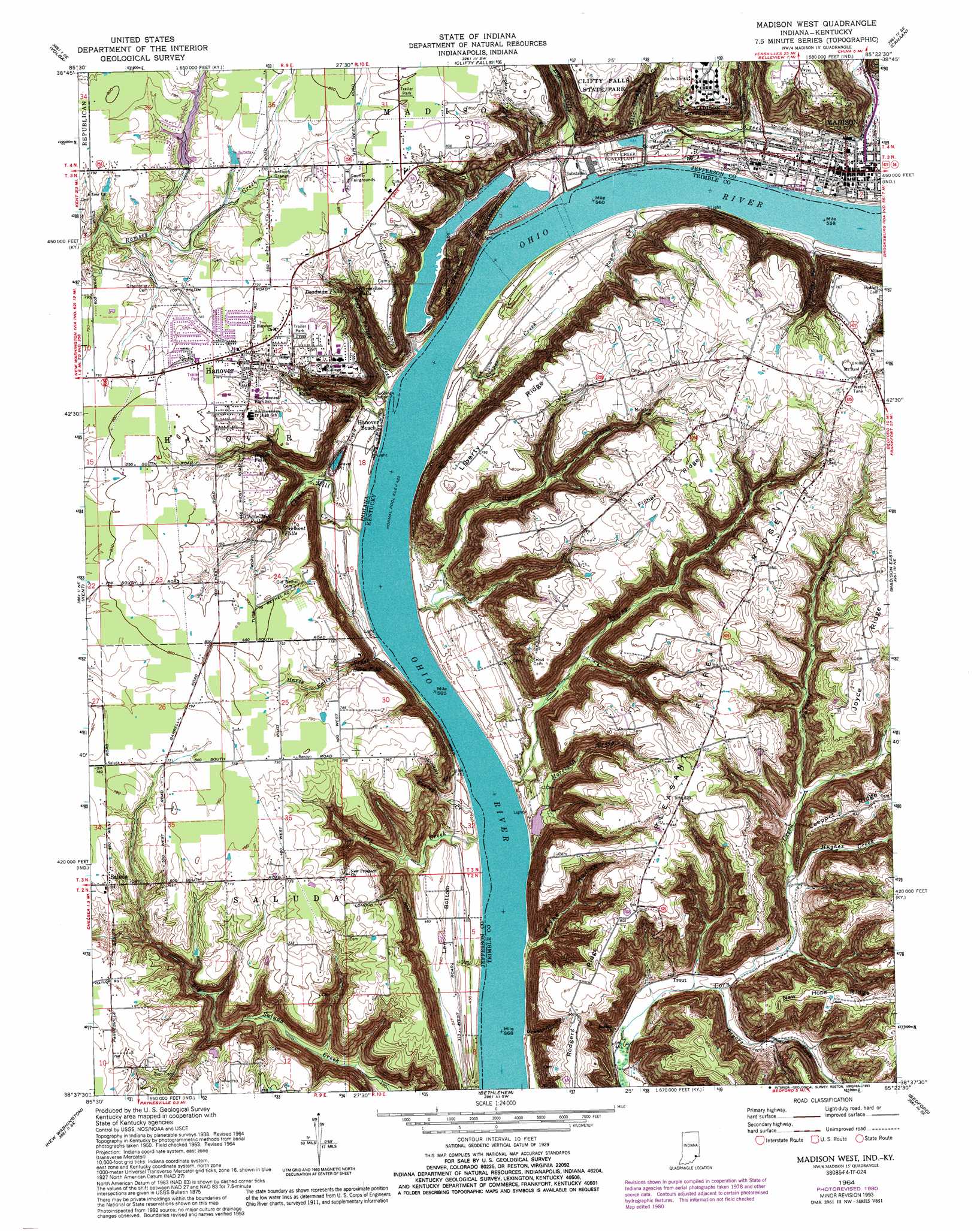
Madison West Topo Map Indiana
To zoom in, hover over the map of Madison West
USGS Topo Quad 38085f4 - 1:24,000 scale
| Topo Map Name: | Madison West |
| USGS Topo Quad ID: | 38085f4 |
| Print Size: | ca. 21 1/4" wide x 27" high |
| Southeast Coordinates: | 38.625° N latitude / 85.375° W longitude |
| Map Center Coordinates: | 38.6875° N latitude / 85.4375° W longitude |
| U.S. States: | IN, KY |
| Filename: | o38085f4.jpg |
| Download Map JPG Image: | Madison West topo map 1:24,000 scale |
| Map Type: | Topographic |
| Topo Series: | 7.5´ |
| Map Scale: | 1:24,000 |
| Source of Map Images: | United States Geological Survey (USGS) |
| Alternate Map Versions: |
Madison West IN 1939 Download PDF Buy paper map Madison West IN 1939 Download PDF Buy paper map Madison West IN 1948 Download PDF Buy paper map Madison West IN 1953, updated 1954 Download PDF Buy paper map Madison West IN 1964, updated 1966 Download PDF Buy paper map Madison West IN 1964, updated 1981 Download PDF Buy paper map Madison West IN 1964, updated 1984 Download PDF Buy paper map Madison West IN 1964, updated 1993 Download PDF Buy paper map Madison West IN 1964, updated 1993 Download PDF Buy paper map Madison West IN 2010 Download PDF Buy paper map Madison West IN 2013 Download PDF Buy paper map Madison West IN 2016 Download PDF Buy paper map |
1:24,000 Topo Quads surrounding Madison West
Hayden |
Vernon |
San Jacinto |
Rexville |
Cross Plains |
Deputy |
Volga |
Clifty Falls |
Canaan |
Bennington |
Blocher |
Kent |
Madison West |
Madison East |
Carrollton |
Otisco |
New Washington |
Bethlehem |
Bedford |
Campbellsburg |
Charlestown |
Owen |
La Grange |
Smithfield |
New Castle |
> Back to 38085e1 at 1:100,000 scale
> Back to 38084a1 at 1:250,000 scale
> Back to U.S. Topo Maps home
Madison West topo map: Gazetteer
Madison West: Falls
Butler Falls elevation 199m 652′Chain Mill Falls elevation 199m 652′
Crowe Falls elevation 170m 557′
Deadman Falls elevation 209m 685′
Fremont Falls elevation 191m 626′
Harts Falls elevation 187m 613′
Horseshoe Falls elevation 209m 685′
Madison West: Flats
Lee Bottom elevation 142m 465′Madison West: Parks
James F D Lanier Memorial elevation 140m 459′Madison West: Populated Places
Antioch Grange elevation 233m 764′Hanover elevation 239m 784′
Hanover Beach elevation 134m 439′
Madison elevation 149m 488′
Saluda elevation 235m 770′
Trout elevation 146m 479′
Madison West: Reservoirs
Rider Lake elevation 237m 777′Madison West: Ridges
Devils Backbone elevation 230m 754′Fisher Ridge elevation 259m 849′
Joyce Ridge elevation 257m 843′
Liberty Ridge elevation 250m 820′
Pleasant Retreat Ridge elevation 261m 856′
Rodgers Ridge elevation 243m 797′
Madison West: Streams
Big Clifty Creek elevation 128m 419′Chain Mill Creek elevation 131m 429′
Cooper Creek elevation 135m 442′
Crooked Creek elevation 128m 419′
Farley Creek elevation 131m 429′
Furnace Branch elevation 168m 551′
Gilmore Creek elevation 128m 419′
Happy Valley Creek elevation 128m 419′
Harts Falls Creek elevation 131m 429′
Hughes Creek elevation 155m 508′
Lee Creek elevation 131m 429′
Little Crooked Creek elevation 131m 429′
Moreland Creek elevation 131m 429′
Page Creek elevation 128m 419′
Pryors Fork elevation 143m 469′
Spring Creek elevation 131m 429′
Madison West: Valleys
Broadway Hollow elevation 138m 452′Preston Hollow elevation 143m 469′
Madison West digital topo map on disk
Buy this Madison West topo map showing relief, roads, GPS coordinates and other geographical features, as a high-resolution digital map file on DVD: