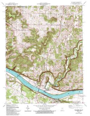
Mauckport Topo Map Indiana
To zoom in, hover over the map of Mauckport
USGS Topo Quad 38086a2 - 1:24,000 scale
| Topo Map Name: | Mauckport |
| USGS Topo Quad ID: | 38086a2 |
| Print Size: | ca. 21 1/4" wide x 27" high |
| Southeast Coordinates: | 38° N latitude / 86.125° W longitude |
| Map Center Coordinates: | 38.0625° N latitude / 86.1875° W longitude |
| U.S. States: | IN, KY |
| Filename: | o38086a2.jpg |
| Download Map JPG Image: | Mauckport topo map 1:24,000 scale |
| Map Type: | Topographic |
| Topo Series: | 7.5´ |
| Map Scale: | 1:24,000 |
| Source of Map Images: | United States Geological Survey (USGS) |
| Alternate Map Versions: |
Mauckport IN 1947 Download PDF Buy paper map Mauckport IN 1950, updated 1954 Download PDF Buy paper map Mauckport IN 1950, updated 1966 Download PDF Buy paper map Mauckport IN 1970, updated 1972 Download PDF Buy paper map Mauckport IN 1970, updated 1994 Download PDF Buy paper map Mauckport IN 2010 Download PDF Buy paper map Mauckport IN 2013 Download PDF Buy paper map Mauckport IN 2016 Download PDF Buy paper map |
1:24,000 Topo Quads surrounding Mauckport
> Back to 38086a1 at 1:100,000 scale
> Back to 38086a1 at 1:250,000 scale
> Back to U.S. Topo Maps home
Mauckport topo map: Gazetteer
Mauckport: Bridges
Matthew Welsh Bridge elevation 116m 380′Matthew Welsh Bridge elevation 116m 380′
Mauckport: Populated Places
Central elevation 213m 698′Glidas elevation 207m 679′
Mauckport elevation 134m 439′
Morvins Landing elevation 116m 380′
Valley City elevation 175m 574′
Mauckport: Ridges
Wolfpen Ridge elevation 235m 770′Mauckport: Streams
Buck Creek elevation 116m 380′Flippins Run elevation 116m 380′
Lick Run elevation 116m 380′
Mauckport: Summits
Hamilton Hill elevation 237m 777′Hayes Hill elevation 282m 925′
Mount Tom elevation 265m 869′
Sand Hill elevation 263m 862′
Shireman Hill elevation 257m 843′
Mauckport: Valleys
Haunted Hollow elevation 121m 396′Mauckport digital topo map on disk
Buy this Mauckport topo map showing relief, roads, GPS coordinates and other geographical features, as a high-resolution digital map file on DVD:


