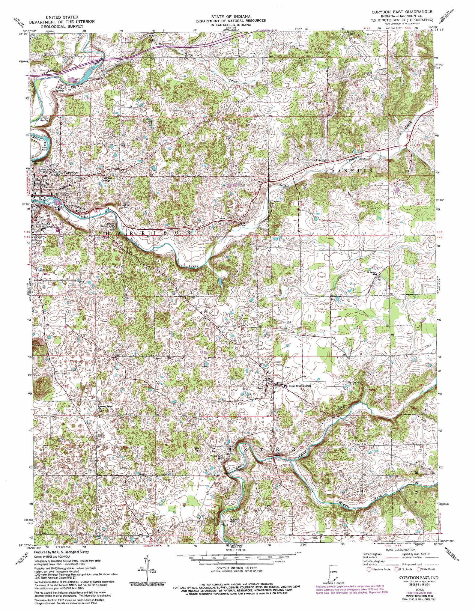
Corydon East Topo Map Indiana
To zoom in, hover over the map of Corydon East
USGS Topo Quad 38086b1 - 1:24,000 scale
| Topo Map Name: | Corydon East |
| USGS Topo Quad ID: | 38086b1 |
| Print Size: | ca. 21 1/4" wide x 27" high |
| Southeast Coordinates: | 38.125° N latitude / 86° W longitude |
| Map Center Coordinates: | 38.1875° N latitude / 86.0625° W longitude |
| U.S. State: | IN |
| Filename: | o38086b1.jpg |
| Download Map JPG Image: | Corydon East topo map 1:24,000 scale |
| Map Type: | Topographic |
| Topo Series: | 7.5´ |
| Map Scale: | 1:24,000 |
| Source of Map Images: | United States Geological Survey (USGS) |
| Alternate Map Versions: |
Corydon East IN 1948 Download PDF Buy paper map Corydon East IN 1966, updated 1968 Download PDF Buy paper map Corydon East IN 1966, updated 1977 Download PDF Buy paper map Corydon East IN 1966, updated 1981 Download PDF Buy paper map Corydon East IN 1966, updated 1983 Download PDF Buy paper map Corydon East IN 1966, updated 1994 Download PDF Buy paper map Corydon East IN 2010 Download PDF Buy paper map Corydon East IN 2013 Download PDF Buy paper map Corydon East IN 2016 Download PDF Buy paper map |
1:24,000 Topo Quads surrounding Corydon East
Hardinsburg |
Fredericksburg |
Palmyra |
Borden |
Speed |
Milltown |
Depauw |
Crandall |
Georgetown |
New Albany |
Leavenworth |
Corydon West |
Corydon East |
Lanesville |
Louisville West |
New Amsterdam |
Mauckport |
Laconia |
Kosmosdale |
Valley Station |
Irvington |
Guston |
Rock Haven |
Fort Knox |
Pitts Point |
> Back to 38086a1 at 1:100,000 scale
> Back to 38086a1 at 1:250,000 scale
> Back to U.S. Topo Maps home
Corydon East topo map: Gazetteer
Corydon East: Airports
Greenridge KLA Airport elevation 260m 853′Corydon East: Dams
Corydon Water Works Dam Number 1 elevation 167m 547′Corydon Water Works Dam Number 2 elevation 172m 564′
Corydon East: Populated Places
Breckenridge elevation 202m 662′Corydon elevation 179m 587′
Harrison Grange elevation 216m 708′
Hillcrest elevation 203m 666′
Kings Store elevation 215m 705′
New Middletown elevation 214m 702′
Corydon East: Reservoirs
Lake Number One elevation 170m 557′Lake Number Two elevation 172m 564′
Corydon East: Springs
Grable Spring elevation 170m 557′Miles Spring elevation 179m 587′
Sulphur Spring elevation 177m 580′
Corydon East: Streams
Brush Heap Creek elevation 173m 567′Middle Fork Buck Creek elevation 177m 580′
Corydon East digital topo map on disk
Buy this Corydon East topo map showing relief, roads, GPS coordinates and other geographical features, as a high-resolution digital map file on DVD: