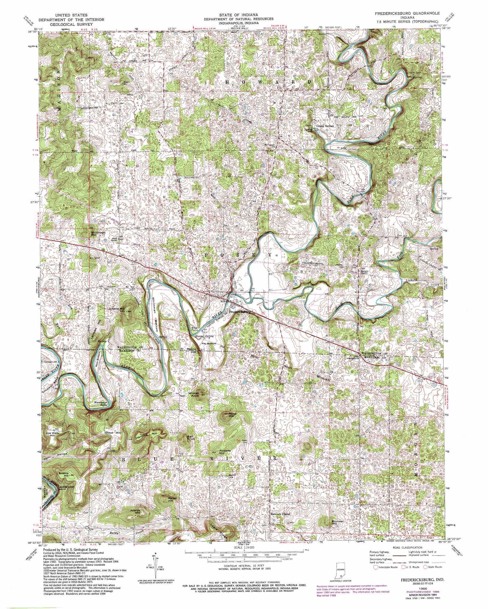
Fredericksburg Topo Map Indiana
To zoom in, hover over the map of Fredericksburg
USGS Topo Quad 38086d2 - 1:24,000 scale
| Topo Map Name: | Fredericksburg |
| USGS Topo Quad ID: | 38086d2 |
| Print Size: | ca. 21 1/4" wide x 27" high |
| Southeast Coordinates: | 38.375° N latitude / 86.125° W longitude |
| Map Center Coordinates: | 38.4375° N latitude / 86.1875° W longitude |
| U.S. State: | IN |
| Filename: | o38086d2.jpg |
| Download Map JPG Image: | Fredericksburg topo map 1:24,000 scale |
| Map Type: | Topographic |
| Topo Series: | 7.5´ |
| Map Scale: | 1:24,000 |
| Source of Map Images: | United States Geological Survey (USGS) |
| Alternate Map Versions: |
Fredericksburg IN 1953, updated 1954 Download PDF Buy paper map Fredericksburg IN 1966, updated 1968 Download PDF Buy paper map Fredericksburg IN 1966, updated 1988 Download PDF Buy paper map Fredericksburg IN 1966, updated 1994 Download PDF Buy paper map Fredericksburg IN 2010 Download PDF Buy paper map Fredericksburg IN 2013 Download PDF Buy paper map Fredericksburg IN 2016 Download PDF Buy paper map |
1:24,000 Topo Quads surrounding Fredericksburg
Mitchell |
Campbellsburg |
Smedley |
Kossuth |
Little York |
Paoli |
Livonia |
Becks Mill |
Salem |
South Boston |
Valeene |
Hardinsburg |
Fredericksburg |
Palmyra |
Borden |
English |
Milltown |
Depauw |
Crandall |
Georgetown |
Beechwood |
Leavenworth |
Corydon West |
Corydon East |
Lanesville |
> Back to 38086a1 at 1:100,000 scale
> Back to 38086a1 at 1:250,000 scale
> Back to U.S. Topo Maps home
Fredericksburg topo map: Gazetteer
Fredericksburg: Bends
Goodman Bend elevation 197m 646′Kay Bottom elevation 185m 606′
Walk Bottom elevation 182m 597′
Whittman Bottom elevation 182m 597′
Fredericksburg: Cliffs
Blice Point elevation 201m 659′Fredericksburg: Islands
Leatherwood Island elevation 171m 561′Fredericksburg: Plains
Mitchell Plain elevation 217m 711′Fredericksburg: Populated Places
Fredericksburg elevation 187m 613′Hancock Chapel elevation 219m 718′
Organ Springs elevation 195m 639′
Fredericksburg: Post Offices
Hancocks Post Office (historical) elevation 220m 721′Fredericksburg: Rapids
Warehouse Riffle elevation 176m 577′Fredericksburg: Springs
Hunter Spring elevation 184m 603′Fredericksburg: Streams
Baldy Creek elevation 186m 610′Licking Creek elevation 188m 616′
South Fork Blue River elevation 183m 600′
Fredericksburg: Summits
Adams Hill elevation 265m 869′Ball Knob elevation 260m 853′
Britton Hill elevation 264m 866′
Brunner Hill elevation 270m 885′
Greene Mill Hill elevation 269m 882′
Hancock Hill elevation 263m 862′
Heiser Hill elevation 255m 836′
Joe Walk Hill elevation 258m 846′
Lambert Hill elevation 236m 774′
McIntosh Hill elevation 256m 839′
Moore Hill elevation 230m 754′
Reno Hill elevation 278m 912′
Roberts Hill elevation 246m 807′
Stout Hill elevation 265m 869′
Wildcat Knob elevation 267m 875′
Fredericksburg digital topo map on disk
Buy this Fredericksburg topo map showing relief, roads, GPS coordinates and other geographical features, as a high-resolution digital map file on DVD: