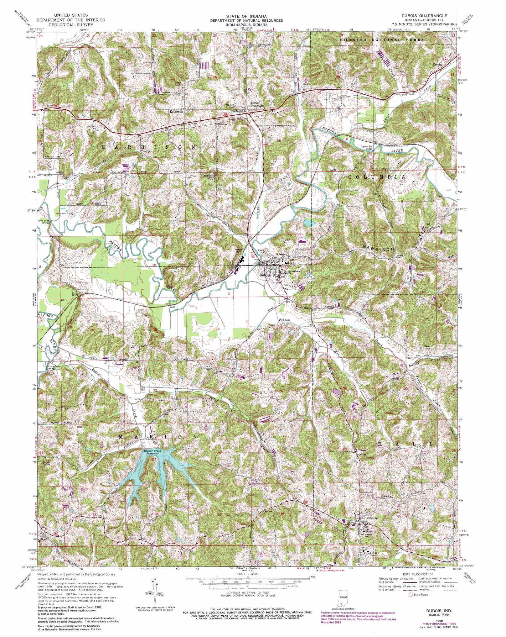
Dubois Topo Map Indiana
To zoom in, hover over the map of Dubois
USGS Topo Quad 38086d7 - 1:24,000 scale
| Topo Map Name: | Dubois |
| USGS Topo Quad ID: | 38086d7 |
| Print Size: | ca. 21 1/4" wide x 27" high |
| Southeast Coordinates: | 38.375° N latitude / 86.75° W longitude |
| Map Center Coordinates: | 38.4375° N latitude / 86.8125° W longitude |
| U.S. State: | IN |
| Filename: | o38086d7.jpg |
| Download Map JPG Image: | Dubois topo map 1:24,000 scale |
| Map Type: | Topographic |
| Topo Series: | 7.5´ |
| Map Scale: | 1:24,000 |
| Source of Map Images: | United States Geological Survey (USGS) |
| Alternate Map Versions: |
Dubois IN 1954, updated 1955 Download PDF Buy paper map Dubois IN 1969, updated 1970 Download PDF Buy paper map Dubois IN 1969, updated 1971 Download PDF Buy paper map Dubois IN 1969, updated 1989 Download PDF Buy paper map Dubois IN 2010 Download PDF Buy paper map Dubois IN 2013 Download PDF Buy paper map Dubois IN 2016 Download PDF Buy paper map |
| FStopo: | US Forest Service topo Dubois is available: Download FStopo PDF Download FStopo TIF |
1:24,000 Topo Quads surrounding Dubois
Montgomery |
Loogootee |
Shoals |
Huron |
Georgia |
Glendale |
Alfordsville |
Rusk |
Hillham |
French Lick |
Otwell |
Jasper |
Dubois |
Cuzco |
Greenbrier |
Velpen |
Huntingburg |
Saint Anthony |
Birdseye |
Taswell |
Holland |
Dale |
Saint Meinrad |
Bristow |
Branchville |
> Back to 38086a1 at 1:100,000 scale
> Back to 38086a1 at 1:250,000 scale
> Back to U.S. Topo Maps home
Dubois topo map: Gazetteer
Dubois: Bridges
Coon Seitz Bridge elevation 140m 459′Crystal Station Bridge elevation 146m 479′
John Seitz Bridge elevation 140m 459′
Dubois: Dams
Beaver Creek Lake Dam elevation 153m 501′Celestine Community Club Lake Dam elevation 170m 557′
Dubois Community Club Lake Dam elevation 148m 485′
Dubois: Parks
Camp Carnes elevation 177m 580′Dubois: Populated Places
Celestine elevation 181m 593′Crystal elevation 153m 501′
Dubois elevation 154m 505′
Dubois Crossroads elevation 156m 511′
Kellerville elevation 189m 620′
Dubois: Post Offices
Ludlow Post Office (historical) elevation 151m 495′Dubois: Ranges
Harbison Hills elevation 223m 731′Dubois: Reservoirs
Beaver Creek Lake elevation 153m 501′Celestine Community Club Lake elevation 170m 557′
Dubois Community Club Lake elevation 148m 485′
Dubois: Streams
Bailey Creek elevation 151m 495′Bauer Creek elevation 146m 479′
Beaver Creek elevation 140m 459′
Davis Creek elevation 146m 479′
Pinnick Creek elevation 152m 498′
Polson Creek elevation 143m 469′
Sugar Creek elevation 146m 479′
Teder Creek elevation 143m 469′
Dubois digital topo map on disk
Buy this Dubois topo map showing relief, roads, GPS coordinates and other geographical features, as a high-resolution digital map file on DVD: