Plainville Topo Map Indiana
To zoom in, hover over the map of Plainville
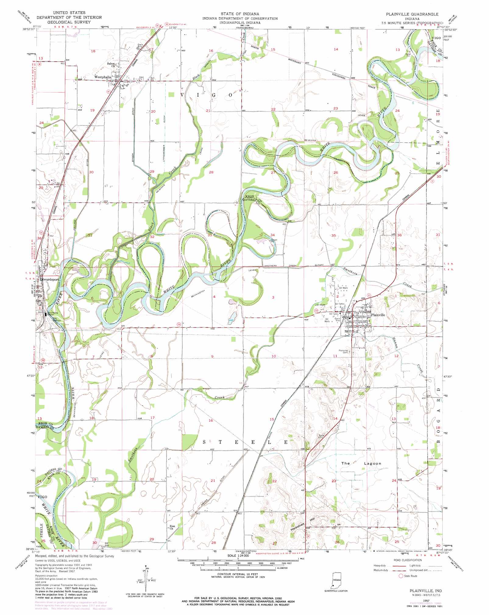
USGS Topo Quad 38087g2 - 1:24,000 scale
| Topo Map Name: | Plainville |
| USGS Topo Quad ID: | 38087g2 |
| Print Size: | ca. 21 1/4" wide x 27" high |
| Southeast Coordinates: | 38.75° N latitude / 87.125° W longitude |
| Map Center Coordinates: | 38.8125° N latitude / 87.1875° W longitude |
| U.S. State: | IN |
| Filename: | o38087g2.jpg |
| Download Map JPG Image: | Plainville topo map 1:24,000 scale |
| Map Type: | Topographic |
| Topo Series: | 7.5´ |
| Map Scale: | 1:24,000 |
| Source of Map Images: | United States Geological Survey (USGS) |
| Alternate Map Versions: |
Plainville IN 1943 Download PDF Buy paper map Plainville IN 1943 Download PDF Buy paper map Plainville IN 1957, updated 1958 Download PDF Buy paper map Plainville IN 1957, updated 1958 Download PDF Buy paper map Plainville IN 1957, updated 1981 Download PDF Buy paper map Plainville IN 2011 Download PDF Buy paper map Plainville IN 2013 Download PDF Buy paper map Plainville IN 2016 Download PDF Buy paper map |
1:24,000 Topo Quads surrounding Plainville
Sullivan |
Dugger |
Linton |
Switz City |
Bloomfield |
Carlisle |
Bucktown |
Sandborn |
Lyons |
Scotland |
Oaktown |
Bicknell |
Plainville |
Epsom |
Odon |
Fritchton |
Wheatland |
Washington |
Montgomery |
Loogootee |
Iona |
Monroe City |
Sandy Hook |
Glendale |
Alfordsville |
> Back to 38087e1 at 1:100,000 scale
> Back to 38086a1 at 1:250,000 scale
> Back to U.S. Topo Maps home
Plainville topo map: Gazetteer
Plainville: Canals
Black Armuth Ditch elevation 140m 459′Linnewebber Ditch elevation 138m 452′
Smothers Creek Cutoff elevation 137m 449′
Plainville: Levees
Bennington Levee elevation 134m 439′Plainville: Populated Places
Plainville elevation 143m 469′Wagner Station elevation 141m 462′
Westphalia elevation 142m 465′
Plainville: Streams
Black Creek elevation 137m 449′Hanna Creek elevation 140m 459′
Plainville: Summits
Harbstreit Hill elevation 168m 551′Plainville: Swamps
The Lagoon elevation 144m 472′Plainville digital topo map on disk
Buy this Plainville topo map showing relief, roads, GPS coordinates and other geographical features, as a high-resolution digital map file on DVD: