Heathsville Topo Map Illinois
To zoom in, hover over the map of Heathsville
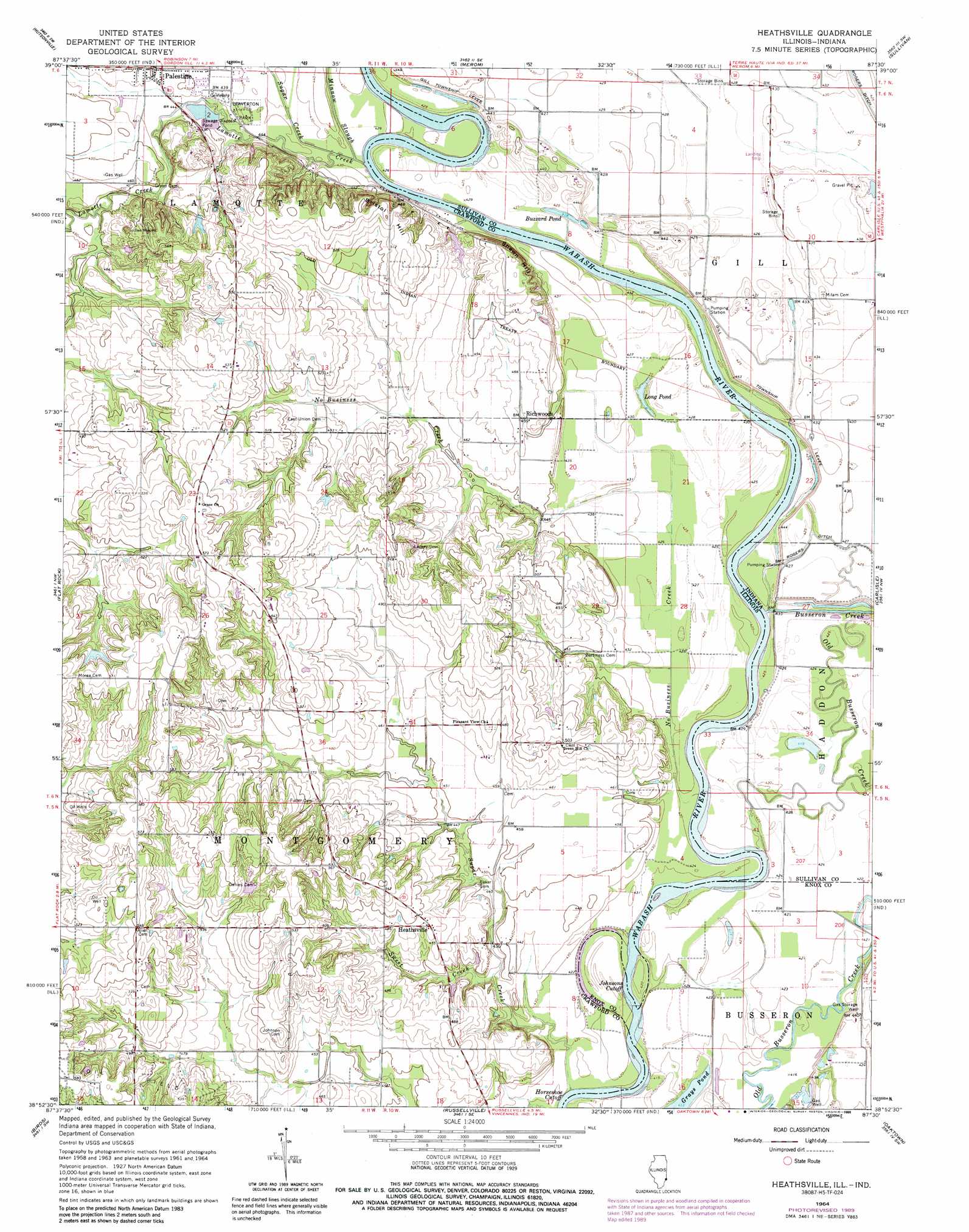
USGS Topo Quad 38087h5 - 1:24,000 scale
| Topo Map Name: | Heathsville |
| USGS Topo Quad ID: | 38087h5 |
| Print Size: | ca. 21 1/4" wide x 27" high |
| Southeast Coordinates: | 38.875° N latitude / 87.5° W longitude |
| Map Center Coordinates: | 38.9375° N latitude / 87.5625° W longitude |
| U.S. States: | IL, IN |
| Filename: | o38087h5.jpg |
| Download Map JPG Image: | Heathsville topo map 1:24,000 scale |
| Map Type: | Topographic |
| Topo Series: | 7.5´ |
| Map Scale: | 1:24,000 |
| Source of Map Images: | United States Geological Survey (USGS) |
| Alternate Map Versions: |
Heathsville IL 1964, updated 1965 Download PDF Buy paper map Heathsville IL 1964, updated 1981 Download PDF Buy paper map Heathsville IL 1964, updated 1989 Download PDF Buy paper map Heathsville IL 2010 Download PDF Buy paper map Heathsville IL 2012 Download PDF Buy paper map Heathsville IL 2015 Download PDF Buy paper map |
1:24,000 Topo Quads surrounding Heathsville
Annapolis |
West Union |
Fairbanks |
Shelburn |
Hymera |
Eaton |
Hutsonville |
Merom |
Sullivan |
Dugger |
Stoy |
Flat Rock |
Heathsville |
Carlisle |
Bucktown |
Chauncey |
Birds |
Russellville |
Oaktown |
Bicknell |
Sumner |
Lawrenceville |
Vincennes |
Fritchton |
Wheatland |
> Back to 38087e1 at 1:100,000 scale
> Back to 38086a1 at 1:250,000 scale
> Back to U.S. Topo Maps home
Heathsville topo map: Gazetteer
Heathsville: Airports
Mann Airport elevation 129m 423′Heathsville: Bends
Horseshoe Cutoff elevation 123m 403′Horseshoe Cutoff elevation 123m 403′
Heathsville: Channels
Johnsons Cutoff elevation 125m 410′Heathsville: Crossings
Hite Ferry (historical) elevation 125m 410′Heathsville: Lakes
Buzzard Pond elevation 127m 416′Grays Pond elevation 126m 413′
Long Pond elevation 126m 413′
Heathsville: Levees
Gill Township Levee elevation 133m 436′Heathsville: Parks
Leaverton Park elevation 134m 439′Heathsville: Populated Places
Heathsville elevation 150m 492′Richwoods elevation 140m 459′
Heathsville: Streams
Lamotte Creek elevation 126m 413′Minnow Slough elevation 128m 419′
No Business Creek elevation 127m 416′
Sugar Creek elevation 131m 429′
Sugar Creek elevation 125m 410′
Sweet Creek elevation 131m 429′
Heathsville: Summits
Bristol Hill elevation 164m 538′Indian Mound elevation 161m 528′
Shawn Hill elevation 165m 541′
Heathsville digital topo map on disk
Buy this Heathsville topo map showing relief, roads, GPS coordinates and other geographical features, as a high-resolution digital map file on DVD: