Rend Lake Dam Topo Map Illinois
To zoom in, hover over the map of Rend Lake Dam
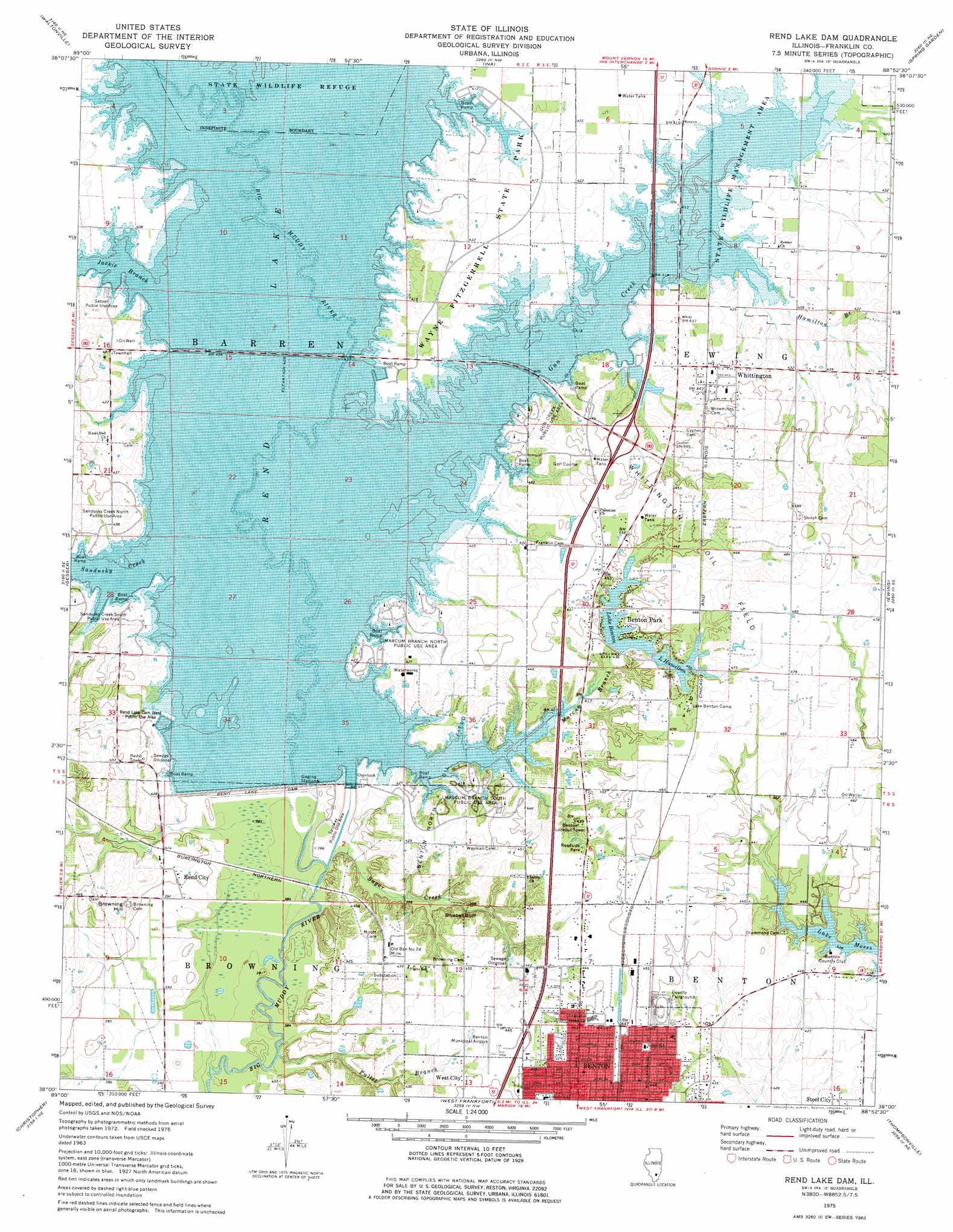
USGS Topo Quad 38088a8 - 1:24,000 scale
| Topo Map Name: | Rend Lake Dam |
| USGS Topo Quad ID: | 38088a8 |
| Print Size: | ca. 21 1/4" wide x 27" high |
| Southeast Coordinates: | 38° N latitude / 88.875° W longitude |
| Map Center Coordinates: | 38.0625° N latitude / 88.9375° W longitude |
| U.S. State: | IL |
| Filename: | o38088a8.jpg |
| Download Map JPG Image: | Rend Lake Dam topo map 1:24,000 scale |
| Map Type: | Topographic |
| Topo Series: | 7.5´ |
| Map Scale: | 1:24,000 |
| Source of Map Images: | United States Geological Survey (USGS) |
| Alternate Map Versions: |
Rend Lake Dam IL 1975, updated 1977 Download PDF Buy paper map Rend Lake Dam IL 1998, updated 2000 Download PDF Buy paper map Rend Lake Dam IL 2012 Download PDF Buy paper map Rend Lake Dam IL 2015 Download PDF Buy paper map |
1:24,000 Topo Quads surrounding Rend Lake Dam
Ashley |
Woodlawn |
Mount Vernon |
Opdyke |
Bluford |
Tamaroa |
Waltonville |
Ina |
Spring Garden |
Dahlgren |
Du Quoin |
Sesser |
Rend Lake Dam |
Ewing |
Macedonia |
Elkville |
Christopher |
West Frankfort |
Thompsonville |
Akin |
Desoto |
Herrin |
Johnston City |
Pittsburg |
Harco |
> Back to 38088a1 at 1:100,000 scale
> Back to 38088a1 at 1:250,000 scale
> Back to U.S. Topo Maps home
Rend Lake Dam topo map: Gazetteer
Rend Lake Dam: Airports
Benton Municipal Airport elevation 134m 439′Rend Lake Conservancy District Heliport elevation 135m 442′
Rend Lake Dam: Cliffs
Bluebell Bluff elevation 128m 419′Rend Lake Dam: Crossings
Interchange 77 elevation 135m 442′Rend Lake Dam: Dams
Lake Benton Dam elevation 132m 433′Lake Hamilton Dam elevation 137m 449′
Rend Lake Dam elevation 120m 393′
Rend Lake Dam: Mines
Old Ben Number 24 Mine elevation 132m 433′Rend Lake Dam: Oilfields
Benton North Oil Field elevation 127m 416′Whittington Oil Field elevation 140m 459′
Rend Lake Dam: Parks
Franklin County Fairground elevation 137m 449′Gun Creek Public Use Area elevation 131m 429′
Marcum Branch North Public Use Area elevation 124m 406′
Marcum Branch South Public Use Area elevation 131m 429′
Rend Lake Dam West Public Use Area elevation 126m 413′
Sandusky Creek North Public Use Area elevation 128m 419′
Sandusky Creek South Public Use Area elevation 129m 423′
Sesser Public Use Area elevation 126m 413′
Spillway Public Use Area elevation 119m 390′
Wayne Fitzgerrell State Park elevation 131m 429′
Rend Lake Dam: Populated Places
Benton Park elevation 135m 442′Rend City elevation 125m 410′
Whittington elevation 135m 442′
Rend Lake Dam: Reservoirs
Lake Benton elevation 132m 433′Lake Hamilton elevation 137m 449′
Rend Lake elevation 120m 393′
Rend Lake Dam: Streams
Casey Fork elevation 123m 403′Fallet Branch elevation 116m 380′
Gun Creek elevation 123m 403′
Hamilton Branch elevation 123m 403′
Jackie Branch elevation 123m 403′
Marcum Branch elevation 123m 403′
Sandusky Creek elevation 123m 403′
Sugar Creek elevation 116m 380′
Rend Lake Dam: Summits
Browning Hill elevation 137m 449′Rend Lake Dam digital topo map on disk
Buy this Rend Lake Dam topo map showing relief, roads, GPS coordinates and other geographical features, as a high-resolution digital map file on DVD: