Hagarstown Topo Map Illinois
To zoom in, hover over the map of Hagarstown
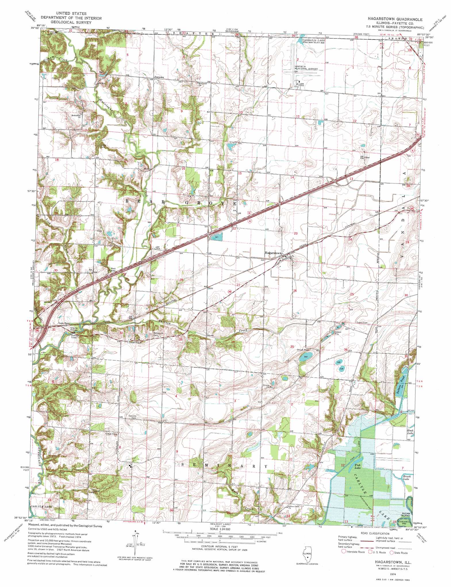
USGS Topo Quad 38089h2 - 1:24,000 scale
| Topo Map Name: | Hagarstown |
| USGS Topo Quad ID: | 38089h2 |
| Print Size: | ca. 21 1/4" wide x 27" high |
| Southeast Coordinates: | 38.875° N latitude / 89.125° W longitude |
| Map Center Coordinates: | 38.9375° N latitude / 89.1875° W longitude |
| U.S. State: | IL |
| Filename: | o38089h2.jpg |
| Download Map JPG Image: | Hagarstown topo map 1:24,000 scale |
| Map Type: | Topographic |
| Topo Series: | 7.5´ |
| Map Scale: | 1:24,000 |
| Source of Map Images: | United States Geological Survey (USGS) |
| Alternate Map Versions: |
Hagarstown IL 1974, updated 1977 Download PDF Buy paper map Hagarstown IL 2012 Download PDF Buy paper map Hagarstown IL 2015 Download PDF Buy paper map |
1:24,000 Topo Quads surrounding Hagarstown
Hillsboro |
Bald Knob |
Ramsey Lake |
Ramsey |
Herrick |
Coffeen |
Fillmore |
Bingham |
Vera |
Avena |
Greenville |
Mulberry Grove |
Hagarstown |
Vandalia |
Brownstown |
Beaver Creek |
Pleasant Mound |
Wildcat Lake |
Patoka |
Saint Paul |
Stolletown |
Keyesport |
Boulder |
Fairman |
Salem North |
> Back to 38089e1 at 1:100,000 scale
> Back to 38088a1 at 1:250,000 scale
> Back to U.S. Topo Maps home
Hagarstown topo map: Gazetteer
Hagarstown: Airports
Lutz Airport elevation 160m 524′Vandalia Municipal Airport elevation 161m 528′
Hagarstown: Canals
Fish Lake Ditch elevation 140m 459′Hagarstown: Crossings
Interchange 61 elevation 162m 531′Hagarstown: Lakes
Brush Lake elevation 139m 456′Fish Lake elevation 139m 456′
Hagarstown: Populated Places
Hagarstown elevation 162m 531′Jimtown elevation 170m 557′
Hagarstown: Post Offices
Hagarstown Post Office elevation 162m 531′Hagarstown: Reservoirs
Suttons Pond elevation 141m 462′Vandalia Lake elevation 161m 528′
Hagarstown: Streams
Gilham Creek elevation 152m 498′Lick Creek elevation 144m 472′
Owl Creek elevation 144m 472′
Raccoon Creek elevation 145m 475′
Hagarstown digital topo map on disk
Buy this Hagarstown topo map showing relief, roads, GPS coordinates and other geographical features, as a high-resolution digital map file on DVD: