Mulberry Grove Topo Map Illinois
To zoom in, hover over the map of Mulberry Grove
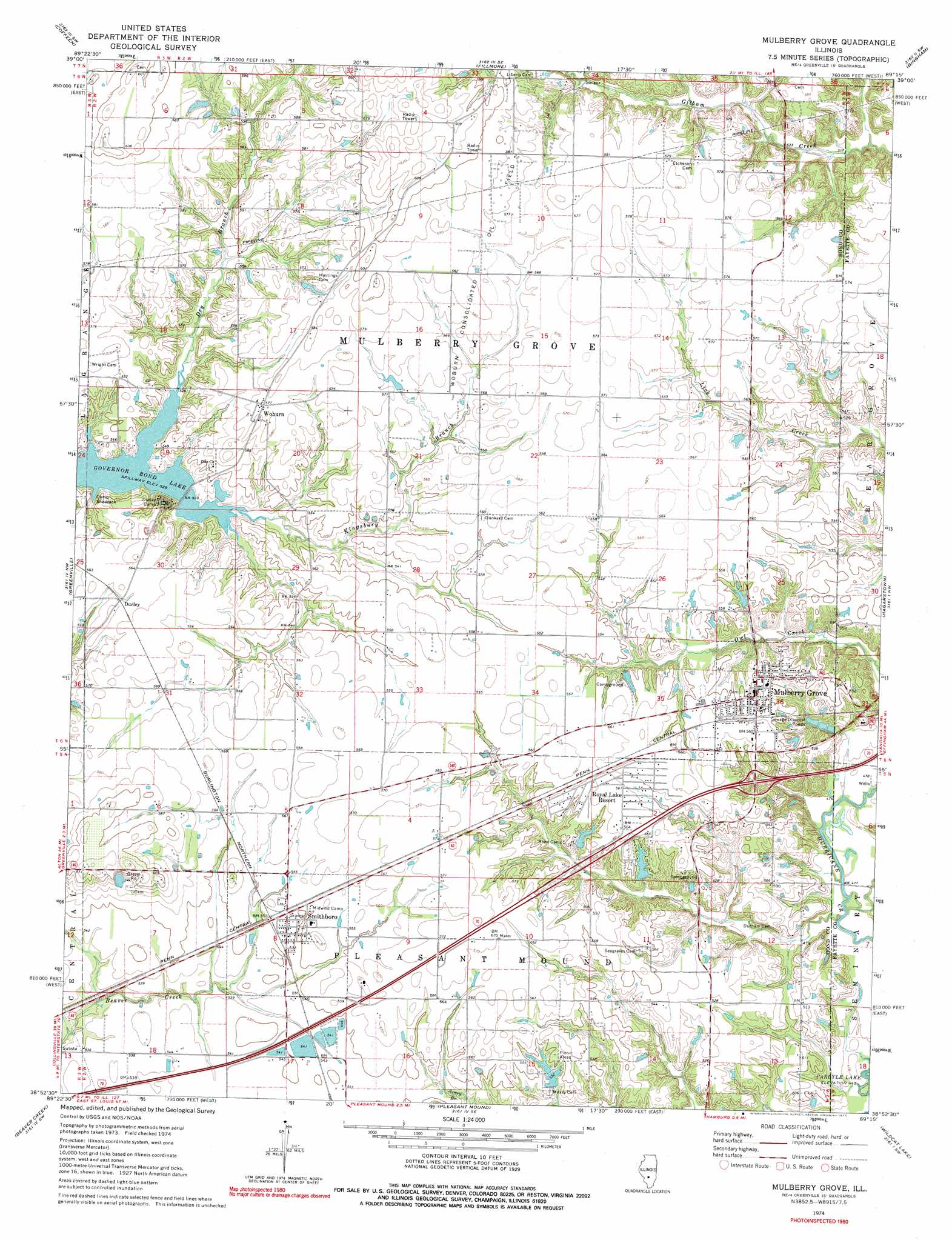
USGS Topo Quad 38089h3 - 1:24,000 scale
| Topo Map Name: | Mulberry Grove |
| USGS Topo Quad ID: | 38089h3 |
| Print Size: | ca. 21 1/4" wide x 27" high |
| Southeast Coordinates: | 38.875° N latitude / 89.25° W longitude |
| Map Center Coordinates: | 38.9375° N latitude / 89.3125° W longitude |
| U.S. State: | IL |
| Filename: | o38089h3.jpg |
| Download Map JPG Image: | Mulberry Grove topo map 1:24,000 scale |
| Map Type: | Topographic |
| Topo Series: | 7.5´ |
| Map Scale: | 1:24,000 |
| Source of Map Images: | United States Geological Survey (USGS) |
| Alternate Map Versions: |
Mulberry Grove IL 1974, updated 1977 Download PDF Buy paper map Mulberry Grove IL 1974, updated 1977 Download PDF Buy paper map Mulberry Grove IL 2012 Download PDF Buy paper map Mulberry Grove IL 2015 Download PDF Buy paper map |
1:24,000 Topo Quads surrounding Mulberry Grove
Butler |
Hillsboro |
Bald Knob |
Ramsey Lake |
Ramsey |
Sorento North |
Coffeen |
Fillmore |
Bingham |
Vera |
Sorento South |
Greenville |
Mulberry Grove |
Hagarstown |
Vandalia |
Pocahontas |
Beaver Creek |
Pleasant Mound |
Wildcat Lake |
Patoka |
Saint Rose |
Stolletown |
Keyesport |
Boulder |
Fairman |
> Back to 38089e1 at 1:100,000 scale
> Back to 38088a1 at 1:250,000 scale
> Back to U.S. Topo Maps home
Mulberry Grove topo map: Gazetteer
Mulberry Grove: Crossings
Interchange 52 elevation 163m 534′Mulberry Grove: Dams
Armstrong Pond Dam elevation 157m 515′Bond Christan Camp Lake Dam elevation 165m 541′
Stone Pond Dam elevation 162m 531′
Mulberry Grove: Oilfields
Woburn Consolidated Oil Field elevation 176m 577′Mulberry Grove: Populated Places
Durley elevation 172m 564′Mulberry Grove elevation 171m 561′
Smithboro elevation 168m 551′
Woburn elevation 175m 574′
Mulberry Grove: Reservoirs
Armstrong Pond elevation 157m 515′Bond Christian Camp Lake elevation 165m 541′
Stone Pond elevation 162m 531′
Mulberry Grove: Streams
Dry Branch elevation 160m 524′Mulberry Grove digital topo map on disk
Buy this Mulberry Grove topo map showing relief, roads, GPS coordinates and other geographical features, as a high-resolution digital map file on DVD: