Danby Topo Map Missouri
To zoom in, hover over the map of Danby
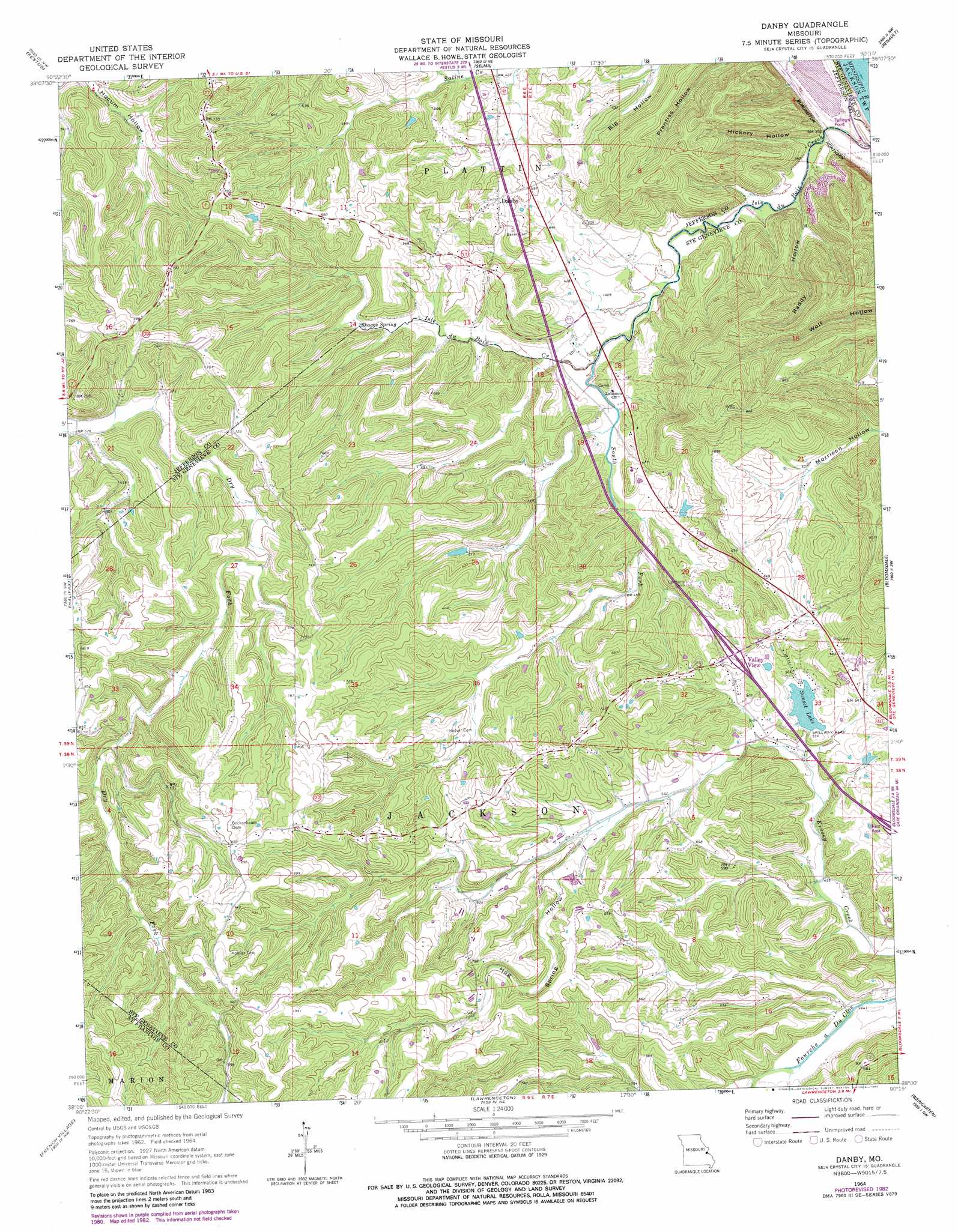
USGS Topo Quad 38090a3 - 1:24,000 scale
| Topo Map Name: | Danby |
| USGS Topo Quad ID: | 38090a3 |
| Print Size: | ca. 21 1/4" wide x 27" high |
| Southeast Coordinates: | 38° N latitude / 90.25° W longitude |
| Map Center Coordinates: | 38.0625° N latitude / 90.3125° W longitude |
| U.S. State: | MO |
| Filename: | o38090a3.jpg |
| Download Map JPG Image: | Danby topo map 1:24,000 scale |
| Map Type: | Topographic |
| Topo Series: | 7.5´ |
| Map Scale: | 1:24,000 |
| Source of Map Images: | United States Geological Survey (USGS) |
| Alternate Map Versions: |
Danby MO 1964, updated 1965 Download PDF Buy paper map Danby MO 1964, updated 1982 Download PDF Buy paper map Danby MO 1993, updated 1996 Download PDF Buy paper map Danby MO 2012 Download PDF Buy paper map Danby MO 2015 Download PDF Buy paper map |
1:24,000 Topo Quads surrounding Danby
Belew Creek |
Herculaneum |
Valmeyer |
Waterloo |
Paderborn |
Desoto |
Festus |
Selma |
Renault |
Ames |
Vineland |
Halifax |
Danby |
Bloomsdale |
Prairie Du Rocher |
Bonne Terre |
French Village |
Lawrenceton |
Weingarten |
Sainte Genevieve |
Flat River |
Farmington |
Sprott |
Coffman |
Minnith |
> Back to 38090a1 at 1:100,000 scale
> Back to 38090a1 at 1:250,000 scale
> Back to U.S. Topo Maps home
Danby topo map: Gazetteer
Danby: Dams
Corbin Lake Dam elevation 151m 495′Sunset Lake Dam elevation 156m 511′
Danby: Populated Places
Danby elevation 169m 554′Kinsey elevation 171m 561′
Valley View elevation 184m 603′
Danby: Reservoirs
Corbin Lake elevation 151m 495′Sunset Lake elevation 155m 508′
Werners Sunset Lake elevation 156m 511′
Danby: Springs
Skaggs Spring elevation 140m 459′Danby: Streams
South Fork Isle du Bois Creek elevation 120m 393′Danby: Valleys
Hickory Hollow elevation 114m 374′Hog Spring Hollow elevation 170m 557′
Raddy Hollow elevation 118m 387′
Danby digital topo map on disk
Buy this Danby topo map showing relief, roads, GPS coordinates and other geographical features, as a high-resolution digital map file on DVD: