Halifax Topo Map Missouri
To zoom in, hover over the map of Halifax
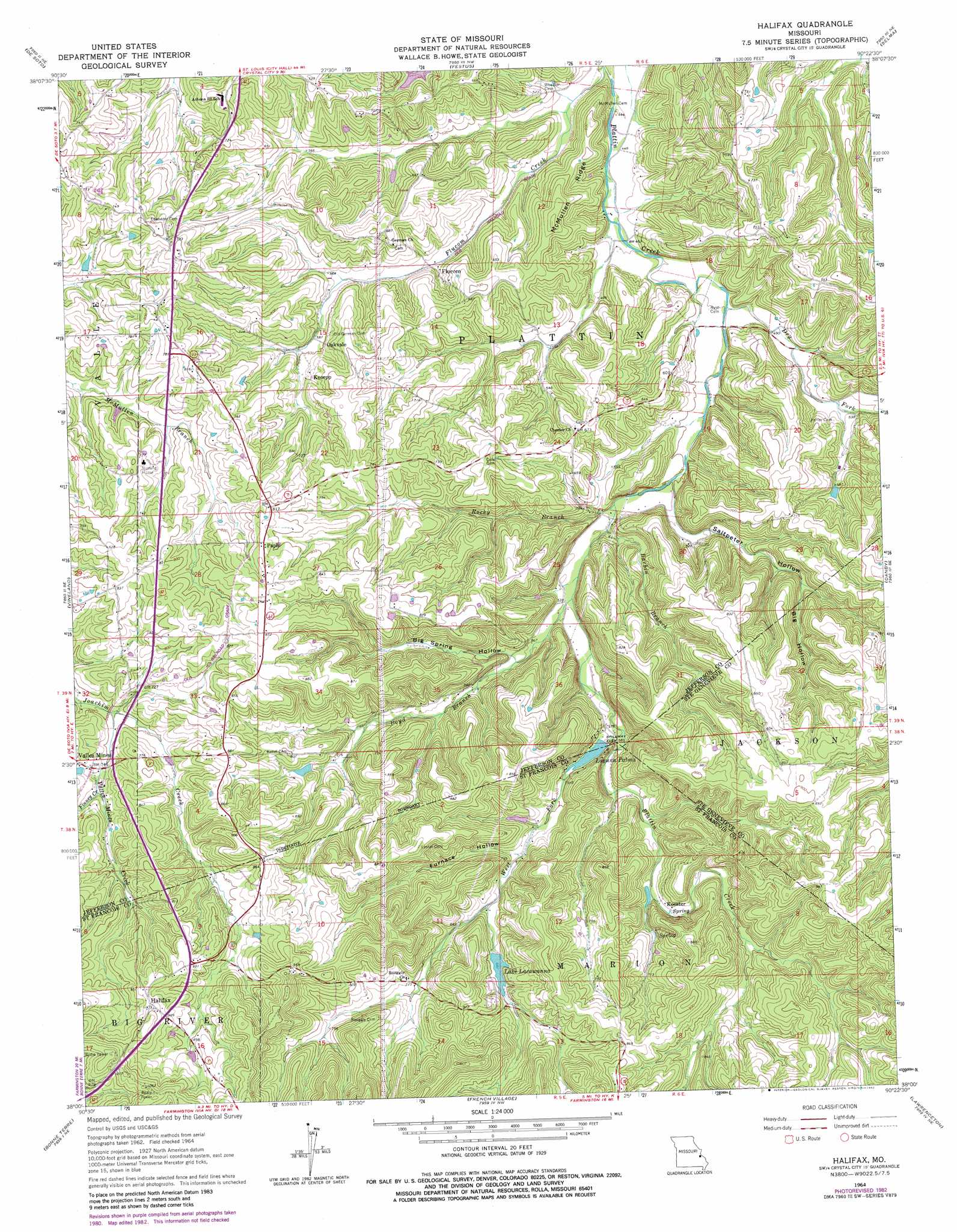
USGS Topo Quad 38090a4 - 1:24,000 scale
| Topo Map Name: | Halifax |
| USGS Topo Quad ID: | 38090a4 |
| Print Size: | ca. 21 1/4" wide x 27" high |
| Southeast Coordinates: | 38° N latitude / 90.375° W longitude |
| Map Center Coordinates: | 38.0625° N latitude / 90.4375° W longitude |
| U.S. State: | MO |
| Filename: | o38090a4.jpg |
| Download Map JPG Image: | Halifax topo map 1:24,000 scale |
| Map Type: | Topographic |
| Topo Series: | 7.5´ |
| Map Scale: | 1:24,000 |
| Source of Map Images: | United States Geological Survey (USGS) |
| Alternate Map Versions: |
Halifax MO 1964, updated 1965 Download PDF Buy paper map Halifax MO 1964, updated 1982 Download PDF Buy paper map Halifax MO 2012 Download PDF Buy paper map Halifax MO 2015 Download PDF Buy paper map |
1:24,000 Topo Quads surrounding Halifax
Cedar Hill |
Belew Creek |
Herculaneum |
Valmeyer |
Waterloo |
Fletcher |
Desoto |
Festus |
Selma |
Renault |
Tiff |
Vineland |
Halifax |
Danby |
Bloomsdale |
Mineral Point |
Bonne Terre |
French Village |
Lawrenceton |
Weingarten |
Irondale |
Flat River |
Farmington |
Sprott |
Coffman |
> Back to 38090a1 at 1:100,000 scale
> Back to 38090a1 at 1:250,000 scale
> Back to U.S. Topo Maps home
Halifax topo map: Gazetteer
Halifax: Dams
Harmans Farm Pond Dam elevation 193m 633′Laguna Palma Dam elevation 178m 583′
Lake Lacawanna Dam elevation 201m 659′
Halifax: Populated Places
Flucom elevation 160m 524′Halifax elevation 300m 984′
Knorpp elevation 189m 620′
Koester elevation 196m 643′
Oakvale elevation 188m 616′
Papin elevation 252m 826′
Valles Mines elevation 233m 764′
Halifax: Reservoirs
Harmons Farm Pond elevation 193m 633′Laguna Palma elevation 178m 583′
Lake Lacawanna elevation 201m 659′
Halifax: Ridges
McMullen Ridge elevation 199m 652′Halifax: Streams
Barbin Branch elevation 157m 515′Boyd Branch elevation 161m 528′
Dry Fork elevation 144m 472′
Finney Creek elevation 218m 715′
Rocky Branch elevation 152m 498′
Valles Mines Creek elevation 206m 675′
West Fork Plattin Creek elevation 171m 561′
Halifax: Valleys
Big Hollow elevation 186m 610′Big Spring Hollow elevation 173m 567′
Furnace Hollow elevation 191m 626′
Saltpeter Hollow elevation 152m 498′
Halifax digital topo map on disk
Buy this Halifax topo map showing relief, roads, GPS coordinates and other geographical features, as a high-resolution digital map file on DVD: