Festus Topo Map Missouri
To zoom in, hover over the map of Festus
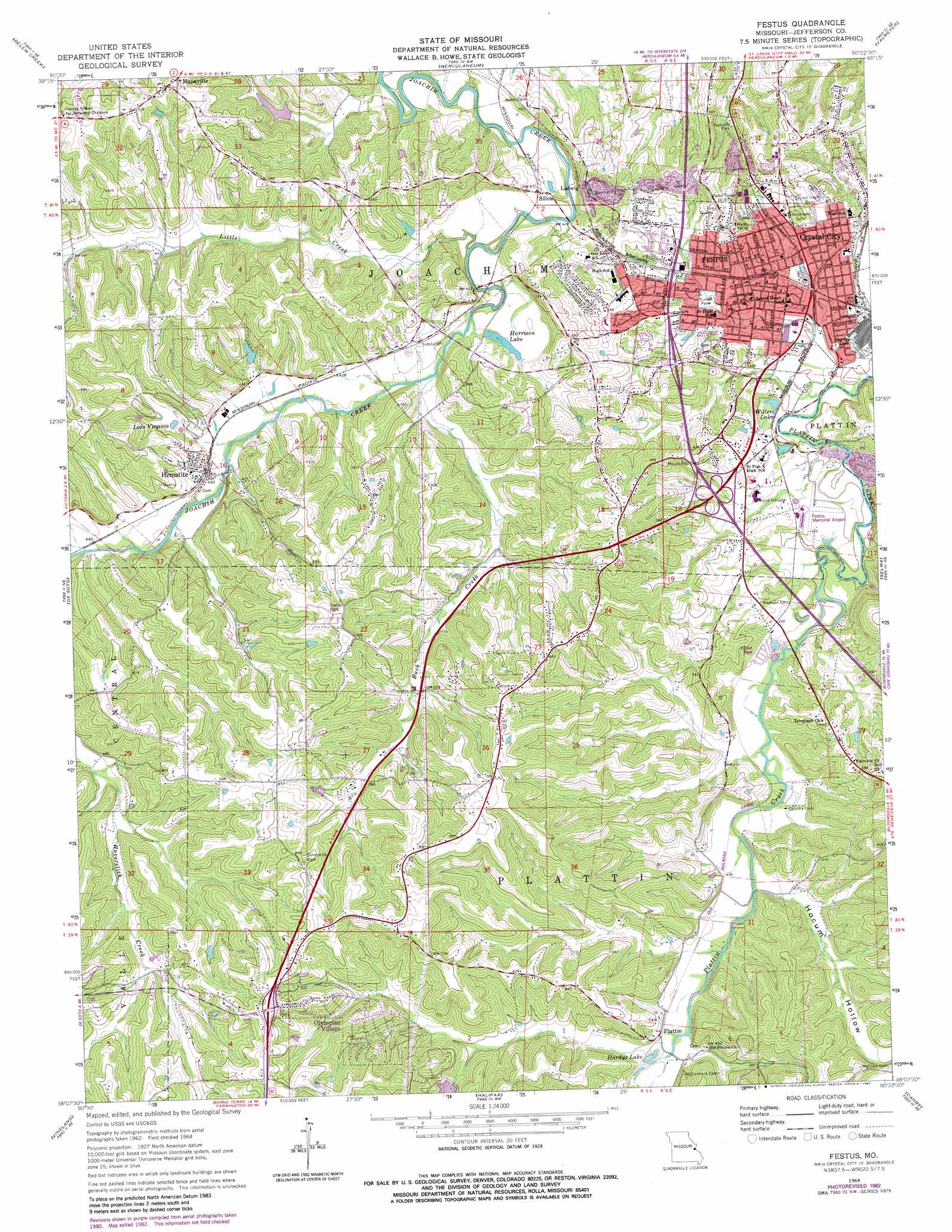
USGS Topo Quad 38090b4 - 1:24,000 scale
| Topo Map Name: | Festus |
| USGS Topo Quad ID: | 38090b4 |
| Print Size: | ca. 21 1/4" wide x 27" high |
| Southeast Coordinates: | 38.125° N latitude / 90.375° W longitude |
| Map Center Coordinates: | 38.1875° N latitude / 90.4375° W longitude |
| U.S. State: | MO |
| Filename: | o38090b4.jpg |
| Download Map JPG Image: | Festus topo map 1:24,000 scale |
| Map Type: | Topographic |
| Topo Series: | 7.5´ |
| Map Scale: | 1:24,000 |
| Source of Map Images: | United States Geological Survey (USGS) |
| Alternate Map Versions: |
Festus MO 1964, updated 1965 Download PDF Buy paper map Festus MO 1964, updated 1982 Download PDF Buy paper map Festus MO 2012 Download PDF Buy paper map Festus MO 2015 Download PDF Buy paper map |
1:24,000 Topo Quads surrounding Festus
Pacific |
House Springs |
Maxville |
Oakville |
Columbia |
Cedar Hill |
Belew Creek |
Herculaneum |
Valmeyer |
Waterloo |
Fletcher |
Desoto |
Festus |
Selma |
Renault |
Tiff |
Vineland |
Halifax |
Danby |
Bloomsdale |
Mineral Point |
Bonne Terre |
French Village |
Lawrenceton |
Weingarten |
> Back to 38090a1 at 1:100,000 scale
> Back to 38090a1 at 1:250,000 scale
> Back to U.S. Topo Maps home
Festus topo map: Gazetteer
Festus: Airports
Festus Memorial Airport elevation 130m 426′Jefferson Memorial Hospital Heliport elevation 127m 416′
Festus: Dams
Lake Trails Dam elevation 142m 465′Lake Virginia Dam elevation 143m 469′
Ogles Lake Dam elevation 143m 469′
Wildwood Lake Dam elevation 162m 531′
Williams Dam elevation 149m 488′
Festus: Lakes
Hardys Lake elevation 134m 439′Festus: Parks
Sunset Park elevation 129m 423′Festus: Populated Places
Bailey elevation 130m 426′Crystal City elevation 135m 442′
Donnell elevation 137m 449′
Festus elevation 132m 433′
Hematite elevation 147m 482′
Ludwig elevation 166m 544′
Mapaville elevation 203m 666′
Olympian Village elevation 181m 593′
Plattin elevation 138m 452′
Silica elevation 128m 419′
Festus: Reservoirs
Harrison Lake elevation 128m 419′Lake Virginia elevation 143m 469′
Wildwood Lake elevation 162m 531′
Willers Lake elevation 122m 400′
Williams Lake elevation 149m 488′
Festus: Streams
Buck Creek elevation 125m 410′Dry Creek elevation 143m 469′
Flucom Creek elevation 134m 439′
Little Creek elevation 120m 393′
Festus: Valleys
Hocum Hollow elevation 129m 423′Festus digital topo map on disk
Buy this Festus topo map showing relief, roads, GPS coordinates and other geographical features, as a high-resolution digital map file on DVD: