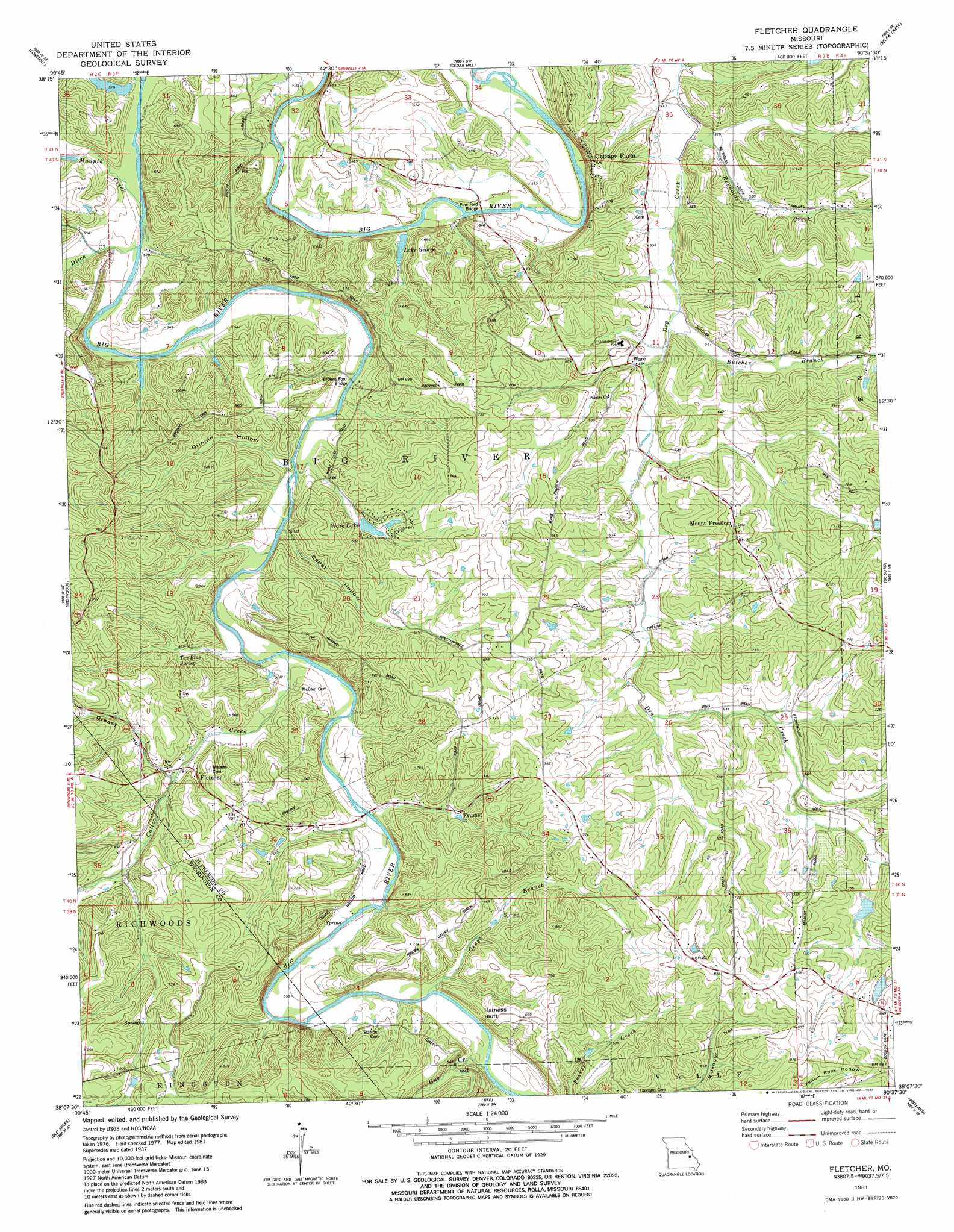
Fletcher Topo Map Missouri
To zoom in, hover over the map of Fletcher
USGS Topo Quad 38090b6 - 1:24,000 scale
| Topo Map Name: | Fletcher |
| USGS Topo Quad ID: | 38090b6 |
| Print Size: | ca. 21 1/4" wide x 27" high |
| Southeast Coordinates: | 38.125° N latitude / 90.625° W longitude |
| Map Center Coordinates: | 38.1875° N latitude / 90.6875° W longitude |
| U.S. State: | MO |
| Filename: | o38090b6.jpg |
| Download Map JPG Image: | Fletcher topo map 1:24,000 scale |
| Map Type: | Topographic |
| Topo Series: | 7.5´ |
| Map Scale: | 1:24,000 |
| Source of Map Images: | United States Geological Survey (USGS) |
| Alternate Map Versions: |
Fletcher MO 1937 Download PDF Buy paper map Fletcher MO 1937, updated 1972 Download PDF Buy paper map Fletcher MO 1938 Download PDF Buy paper map Fletcher MO 1981, updated 1982 Download PDF Buy paper map Fletcher MO 2012 Download PDF Buy paper map Fletcher MO 2015 Download PDF Buy paper map |
1:24,000 Topo Quads surrounding Fletcher
Moselle |
Gray Summit |
Pacific |
House Springs |
Maxville |
Saint Clair |
Lonedell |
Cedar Hill |
Belew Creek |
Herculaneum |
Cyclone Hollow |
Richwoods |
Fletcher |
Desoto |
Festus |
Ebo |
Old Mines |
Tiff |
Vineland |
Halifax |
Shirley |
Potosi |
Mineral Point |
Bonne Terre |
French Village |
> Back to 38090a1 at 1:100,000 scale
> Back to 38090a1 at 1:250,000 scale
> Back to U.S. Topo Maps home
Fletcher topo map: Gazetteer
Fletcher: Bridges
Browns Ford Bridge elevation 156m 511′Pine Ford Bridge elevation 148m 485′
Fletcher: Cliffs
Harness Bluff elevation 214m 702′Fletcher: Dams
Anderson Lake Dam elevation 197m 646′Flat Rock Lake Dam elevation 157m 515′
Kinnippi Lake Dam elevation 243m 797′
Lake George Dam elevation 161m 528′
Lake Lorene Dam elevation 162m 531′
Paw-Paw Lake Dam elevation 214m 702′
Taylor Lake Dam elevation 169m 554′
Ware Lake Dam elevation 179m 587′
Fletcher: Populated Places
Cottage Farm elevation 207m 679′Fletcher elevation 172m 564′
Frumet elevation 182m 597′
Mount Freedom elevation 227m 744′
Ware elevation 167m 547′
Fletcher: Reservoirs
Anderson Lake elevation 197m 646′Kinnippi Lake elevation 243m 797′
Lake George elevation 161m 528′
Paw-Paw Lake elevation 214m 702′
Pine Ford Lake elevation 152m 498′
Ware Lake elevation 179m 587′
Fletcher: Springs
Tar Blue Spring elevation 184m 603′Fletcher: Streams
Butcher Branch elevation 162m 531′Calico Creek elevation 157m 515′
Ditch Creek elevation 154m 505′
Greys Branch elevation 165m 541′
Gus Creek elevation 167m 547′
Kruze Creek elevation 152m 498′
Mammoth Creek elevation 174m 570′
Maupin Creek elevation 153m 501′
Reynolds Creek elevation 152m 498′
Fletcher: Valleys
Cedar Hollow elevation 158m 518′Grassy Hollow elevation 176m 577′
Grinnin Hollow elevation 161m 528′
Hoot Owl Hollow elevation 167m 547′
Ridenour Hollow elevation 192m 629′
Yellow Rock Hollow elevation 192m 629′
Fletcher digital topo map on disk
Buy this Fletcher topo map showing relief, roads, GPS coordinates and other geographical features, as a high-resolution digital map file on DVD: