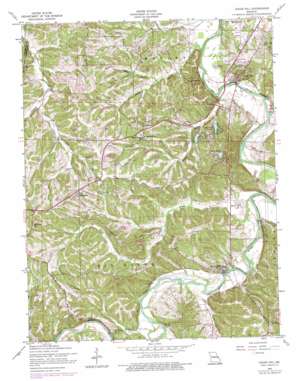
Cedar Hill Topo Map Missouri
To zoom in, hover over the map of Cedar Hill
USGS Topo Quad 38090c6 - 1:24,000 scale
| Topo Map Name: | Cedar Hill |
| USGS Topo Quad ID: | 38090c6 |
| Print Size: | ca. 21 1/4" wide x 27" high |
| Southeast Coordinates: | 38.25° N latitude / 90.625° W longitude |
| Map Center Coordinates: | 38.3125° N latitude / 90.6875° W longitude |
| U.S. State: | MO |
| Filename: | o38090c6.jpg |
| Download Map JPG Image: | Cedar Hill topo map 1:24,000 scale |
| Map Type: | Topographic |
| Topo Series: | 7.5´ |
| Map Scale: | 1:24,000 |
| Source of Map Images: | United States Geological Survey (USGS) |
| Alternate Map Versions: |
Cedar Hill MO 1938 Download PDF Buy paper map Cedar Hill MO 1938, updated 1940 Download PDF Buy paper map Cedar Hill MO 1954, updated 1959 Download PDF Buy paper map Cedar Hill MO 1954, updated 1966 Download PDF Buy paper map Cedar Hill MO 1954, updated 1969 Download PDF Buy paper map Cedar Hill MO 1954, updated 1975 Download PDF Buy paper map Cedar Hill MO 1954, updated 1975 Download PDF Buy paper map Cedar Hill MO 2012 Download PDF Buy paper map Cedar Hill MO 2015 Download PDF Buy paper map |
1:24,000 Topo Quads surrounding Cedar Hill
> Back to 38090a1 at 1:100,000 scale
> Back to 38090a1 at 1:250,000 scale
> Back to U.S. Topo Maps home
Cedar Hill topo map: Gazetteer
Cedar Hill: Dams
Cedar Hill Lake Number 1 Dam elevation 151m 495′Cedar Hill Lake Number 2 Dam elevation 160m 524′
Cedar Hill Lake Number 3 Dam elevation 165m 541′
Cedar Ridge Number 2 Dam elevation 190m 623′
Des Peres Quarry Lake Dam elevation 153m 501′
Hidden Valley Lake Dam elevation 185m 606′
Lake Adelle Dam elevation 176m 577′
Lake Maryann Dam elevation 194m 636′
Lakes Famar Lower Dam elevation 224m 734′
Lakes Famar Upper Dam elevation 227m 744′
Number 883 Dam elevation 170m 557′
Number 884 Dam elevation 203m 666′
Ryan Lake Dam elevation 241m 790′
Stewart Lake Dam elevation 179m 587′
Sun Fish Lake Dam elevation 170m 557′
Turn-Bo Dam elevation 206m 675′
Cedar Hill: Populated Places
Cedar Hill elevation 168m 551′Cedar Hill Lakes elevation 193m 633′
Cedar Hill Manor elevation 159m 521′
Dittmer elevation 204m 669′
Morse Mill elevation 159m 521′
Oermann elevation 241m 790′
One Hundred and One Ranch elevation 182m 597′
Cedar Hill: Reservoirs
Cedar Hill Lake Number 1 elevation 151m 495′Cedar Hill Lake Number 2 elevation 160m 524′
Cedar Hill Lake Number 3 elevation 165m 541′
Cedar Hill Lakes elevation 146m 479′
Hidden Valley Lake elevation 185m 606′
Kirchners Lake elevation 170m 557′
Lake Adelle elevation 176m 577′
Lakes Famar elevation 224m 734′
Lakes Famar elevation 227m 744′
Turn-Bo Lake elevation 206m 675′
Cedar Hill: Streams
Belews Creek elevation 140m 459′Bethlehem Creek elevation 146m 479′
Dry Creek elevation 145m 475′
Dutch Creek elevation 136m 446′
Isum Creek elevation 138m 452′
Jones Creek elevation 142m 465′
North Fork Jones Creek elevation 163m 534′
Skullbones Creek elevation 136m 446′
West Fork Jones Creek elevation 163m 534′
Wine Creek elevation 151m 495′
Cedar Hill digital topo map on disk
Buy this Cedar Hill topo map showing relief, roads, GPS coordinates and other geographical features, as a high-resolution digital map file on DVD:


