Maxville Topo Map Missouri
To zoom in, hover over the map of Maxville
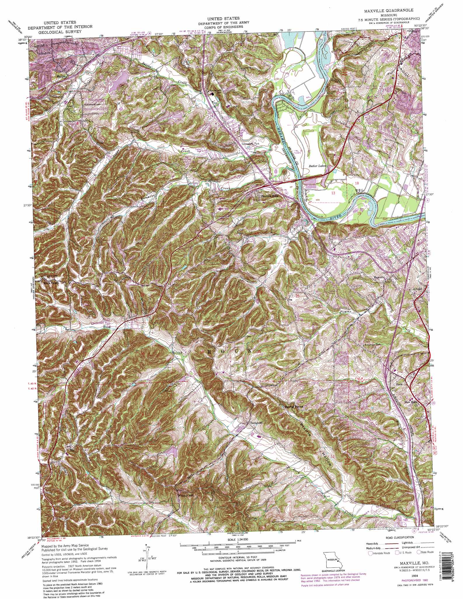
USGS Topo Quad 38090d4 - 1:24,000 scale
| Topo Map Name: | Maxville |
| USGS Topo Quad ID: | 38090d4 |
| Print Size: | ca. 21 1/4" wide x 27" high |
| Southeast Coordinates: | 38.375° N latitude / 90.375° W longitude |
| Map Center Coordinates: | 38.4375° N latitude / 90.4375° W longitude |
| U.S. State: | MO |
| Filename: | o38090d4.jpg |
| Download Map JPG Image: | Maxville topo map 1:24,000 scale |
| Map Type: | Topographic |
| Topo Series: | 7.5´ |
| Map Scale: | 1:24,000 |
| Source of Map Images: | United States Geological Survey (USGS) |
| Alternate Map Versions: |
Maxville MO 1954, updated 1959 Download PDF Buy paper map Maxville MO 1954, updated 1969 Download PDF Buy paper map Maxville MO 1954, updated 1975 Download PDF Buy paper map Maxville MO 1954, updated 1982 Download PDF Buy paper map Maxville MO 1954, updated 1982 Download PDF Buy paper map Maxville MO 2012 Download PDF Buy paper map Maxville MO 2015 Download PDF Buy paper map |
1:24,000 Topo Quads surrounding Maxville
Weldon Spring |
Chesterfield |
Creve Coeur |
Clayton |
Granite City |
Eureka |
Manchester |
Kirkwood |
Webster Groves |
Cahokia |
Pacific |
House Springs |
Maxville |
Oakville |
Columbia |
Cedar Hill |
Belew Creek |
Herculaneum |
Valmeyer |
Waterloo |
Fletcher |
Desoto |
Festus |
Selma |
Renault |
> Back to 38090a1 at 1:100,000 scale
> Back to 38090a1 at 1:250,000 scale
> Back to U.S. Topo Maps home
Maxville topo map: Gazetteer
Maxville: Crossings
Interchange 190 elevation 162m 531′Interchange 191 elevation 144m 472′
Maxville: Dams
Fon-Du-Lac Dam elevation 159m 521′Four Ridge Dam elevation 182m 597′
General American Life Insurance Lake Dam elevation 168m 551′
Glen Rose Lake Dam elevation 173m 567′
Hermitage Hills Lake Dam elevation 139m 456′
Pine Lake Dam elevation 226m 741′
Maxville: Parks
Mastodon State Park elevation 125m 410′Spring Lake Park elevation 182m 597′
Springdale Park elevation 122m 400′
Suson Park elevation 148m 485′
Maxville: Populated Places
Arnold elevation 184m 603′Beck elevation 175m 574′
Jefferson Heights elevation 277m 908′
Maxville elevation 172m 564′
Murphy elevation 175m 574′
Paulina Hills elevation 131m 429′
Rock Creek elevation 251m 823′
Seckman elevation 166m 544′
Spring Forest elevation 221m 725′
Maxville: Reservoirs
Butler Lakes elevation 120m 393′Fon-Du-Lac Reservoir elevation 159m 521′
Four Ridge Lake elevation 182m 597′
Lake Glen Rose elevation 173m 567′
Number 216 Reservoir elevation 139m 456′
Pine Lake elevation 226m 741′
Maxville: Streams
Black Creek elevation 121m 396′Romaine Creek elevation 121m 396′
Saline Creek elevation 120m 393′
Sugar Creek elevation 121m 396′
Maxville: Summits
Frisco Hill elevation 247m 810′Maxville: Valleys
Prairie Hollow elevation 132m 433′Maxville digital topo map on disk
Buy this Maxville topo map showing relief, roads, GPS coordinates and other geographical features, as a high-resolution digital map file on DVD: