Gray Summit Topo Map Missouri
To zoom in, hover over the map of Gray Summit
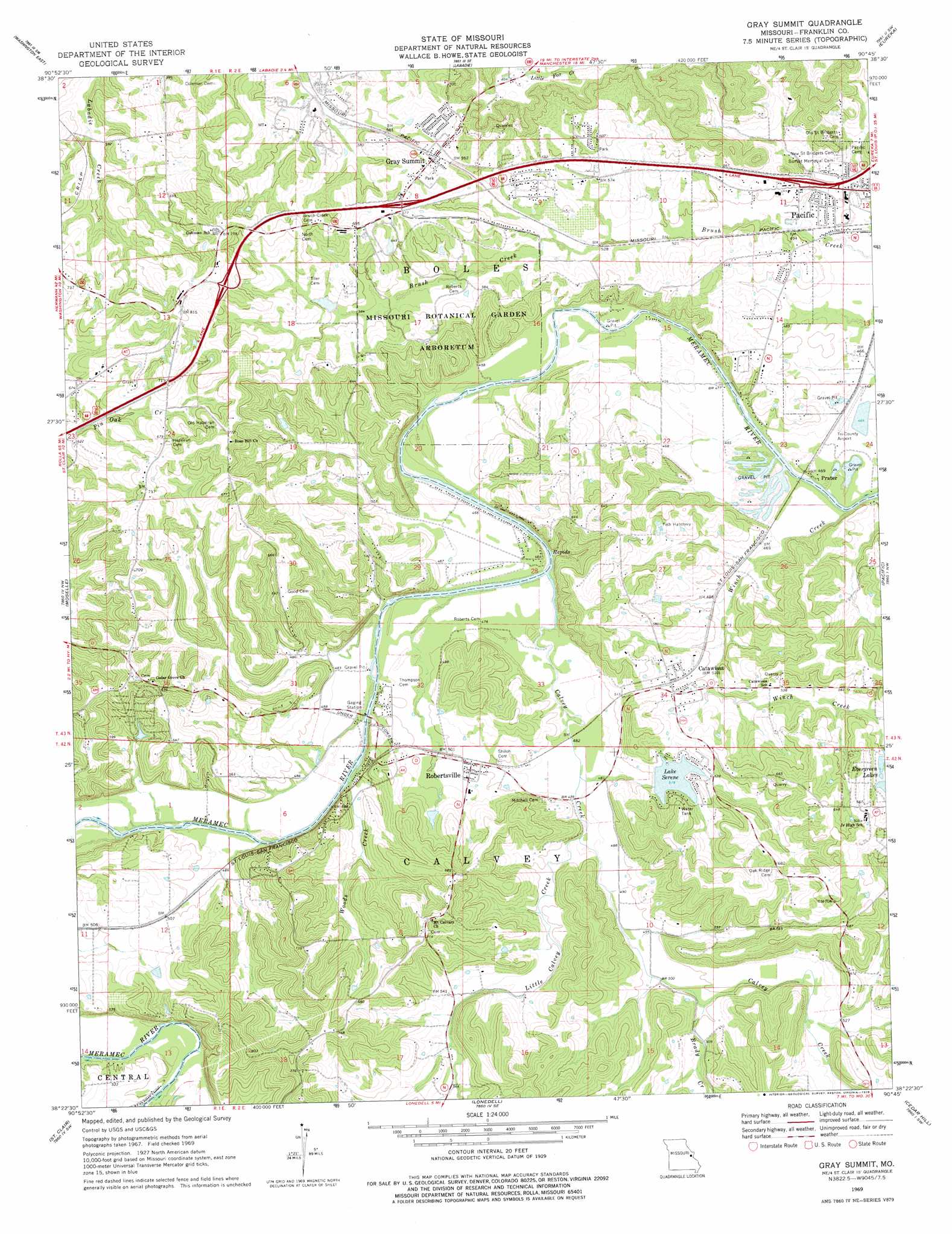
USGS Topo Quad 38090d7 - 1:24,000 scale
| Topo Map Name: | Gray Summit |
| USGS Topo Quad ID: | 38090d7 |
| Print Size: | ca. 21 1/4" wide x 27" high |
| Southeast Coordinates: | 38.375° N latitude / 90.75° W longitude |
| Map Center Coordinates: | 38.4375° N latitude / 90.8125° W longitude |
| U.S. State: | MO |
| Filename: | o38090d7.jpg |
| Download Map JPG Image: | Gray Summit topo map 1:24,000 scale |
| Map Type: | Topographic |
| Topo Series: | 7.5´ |
| Map Scale: | 1:24,000 |
| Source of Map Images: | United States Geological Survey (USGS) |
| Alternate Map Versions: |
Gray Summit MO 1969, updated 1971 Download PDF Buy paper map Gray Summit MO 2012 Download PDF Buy paper map Gray Summit MO 2015 Download PDF Buy paper map |
1:24,000 Topo Quads surrounding Gray Summit
Marthasville |
New Melle |
Defiance |
Weldon Spring |
Chesterfield |
Washington West |
Washington East |
Labadie |
Eureka |
Manchester |
Union |
Moselle |
Gray Summit |
Pacific |
House Springs |
Stanton |
Saint Clair |
Lonedell |
Cedar Hill |
Belew Creek |
Meramec State Park |
Cyclone Hollow |
Richwoods |
Fletcher |
Desoto |
> Back to 38090a1 at 1:100,000 scale
> Back to 38090a1 at 1:250,000 scale
> Back to U.S. Topo Maps home
Gray Summit topo map: Gazetteer
Gray Summit: Crossings
Interchange 257 elevation 158m 518′Gray Summit: Dams
Buckner Dam elevation 145m 475′Evergreen Lake Upper Dam elevation 185m 606′
Evergreen Lakes Lower Dam elevation 185m 606′
G Gundaker Dam elevation 179m 587′
High Meadow Lake Dam elevation 165m 541′
Johns Lake Dam elevation 164m 538′
Johnson Lake Dam elevation 154m 505′
Lake Serene Dam elevation 155m 508′
McAdams Lake Dam elevation 194m 636′
Missouri Botanical Gardens Lake Dam elevation 194m 636′
Pacific Fishing Lake Dam elevation 152m 498′
Strothmann Lake Dam elevation 185m 606′
Watson Lake Dam elevation 161m 528′
Woodland Hills Subdivision Lake Dam elevation 163m 534′
Gray Summit: Parks
Missouri Botanical Garden Arboretum elevation 185m 606′Gray Summit: Populated Places
Catawissa elevation 163m 534′Gray Summit elevation 203m 666′
Meramec Terrace elevation 154m 505′
Prater elevation 140m 459′
Robertsville elevation 154m 505′
The Diamonds elevation 243m 797′
Gray Summit: Reservoirs
Evergreen Lakes elevation 179m 587′Kober Lake elevation 152m 498′
Lake Serene elevation 155m 508′
Leo Politte and John Lynch Lake elevation 165m 541′
Seyer Lake elevation 145m 475′
Shaw S Garden Lake elevation 194m 636′
Gray Summit: Streams
Brady Creek elevation 149m 488′Calvey Creek elevation 140m 459′
Little Calvey Creek elevation 146m 479′
Winch Creek elevation 139m 456′
Woods Creek elevation 140m 459′
Gray Summit digital topo map on disk
Buy this Gray Summit topo map showing relief, roads, GPS coordinates and other geographical features, as a high-resolution digital map file on DVD: