Manchester Topo Map Missouri
To zoom in, hover over the map of Manchester
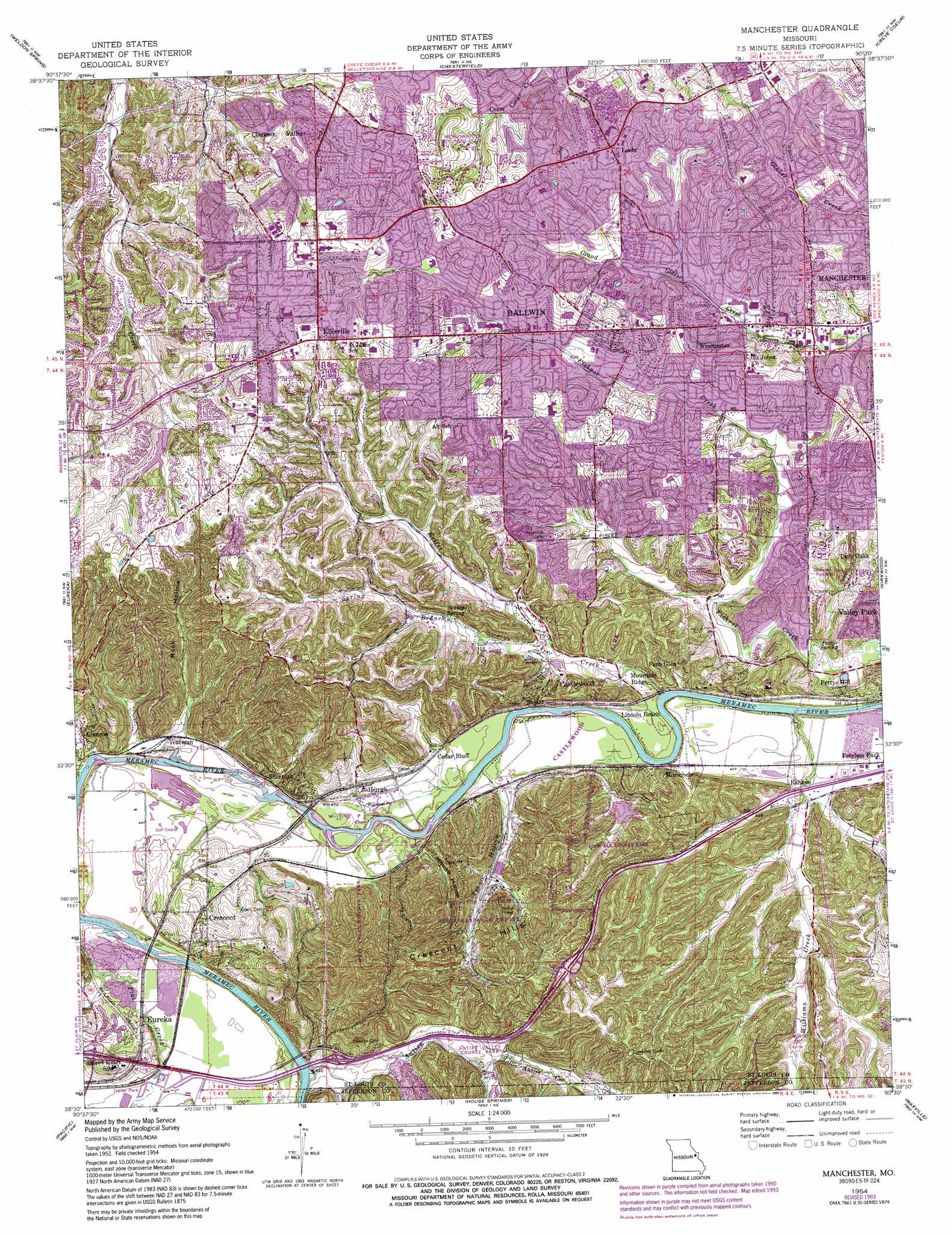
USGS Topo Quad 38090e5 - 1:24,000 scale
| Topo Map Name: | Manchester |
| USGS Topo Quad ID: | 38090e5 |
| Print Size: | ca. 21 1/4" wide x 27" high |
| Southeast Coordinates: | 38.5° N latitude / 90.5° W longitude |
| Map Center Coordinates: | 38.5625° N latitude / 90.5625° W longitude |
| U.S. State: | MO |
| Filename: | o38090e5.jpg |
| Download Map JPG Image: | Manchester topo map 1:24,000 scale |
| Map Type: | Topographic |
| Topo Series: | 7.5´ |
| Map Scale: | 1:24,000 |
| Source of Map Images: | United States Geological Survey (USGS) |
| Alternate Map Versions: |
Manchester MO 1945, updated 1955 Download PDF Buy paper map Manchester MO 1947 Download PDF Buy paper map Manchester MO 1954, updated 1959 Download PDF Buy paper map Manchester MO 1954, updated 1966 Download PDF Buy paper map Manchester MO 1954, updated 1969 Download PDF Buy paper map Manchester MO 1954, updated 1975 Download PDF Buy paper map Manchester MO 1954, updated 1982 Download PDF Buy paper map Manchester MO 1954, updated 1988 Download PDF Buy paper map Manchester MO 1954, updated 1993 Download PDF Buy paper map Manchester MO 1954, updated 1993 Download PDF Buy paper map Manchester MO 1979, updated 1981 Download PDF Buy paper map Manchester MO 2012 Download PDF Buy paper map Manchester MO 2015 Download PDF Buy paper map |
1:24,000 Topo Quads surrounding Manchester
Wentzville |
O'Fallon |
Kampville |
Saint Charles |
Florissant |
Defiance |
Weldon Spring |
Chesterfield |
Creve Coeur |
Clayton |
Labadie |
Eureka |
Manchester |
Kirkwood |
Webster Groves |
Gray Summit |
Pacific |
House Springs |
Maxville |
Oakville |
Lonedell |
Cedar Hill |
Belew Creek |
Herculaneum |
Valmeyer |
> Back to 38090e1 at 1:100,000 scale
> Back to 38090a1 at 1:250,000 scale
> Back to U.S. Topo Maps home
Manchester topo map: Gazetteer
Manchester: Crossings
Interchange 264 elevation 158m 518′Interchange 265 elevation 134m 439′
Interchange 266 elevation 144m 472′
Interchange 269 elevation 204m 669′
Manchester: Dams
Fabick Lake Dam elevation 187m 613′Kehrs Mill Trails Subdivision Lake C Dam elevation 146m 479′
Lone Elk Lower Dam elevation 150m 492′
Lone Elk-Upper Dam elevation 185m 606′
Sturmfels Lake Dam elevation 186m 610′
Top Notch Lake Dam elevation 221m 725′
Manchester: Parks
Antire Valley County Park elevation 147m 482′Castlewood State Park elevation 127m 416′
Lone Elk County Park elevation 151m 495′
West Tyson County Park elevation 231m 757′
Manchester: Populated Places
Ballwin elevation 192m 629′Castlewood elevation 171m 561′
Cedar Bluff elevation 135m 442′
Clarkson Valley elevation 180m 590′
Crescent elevation 156m 511′
Ellisville elevation 221m 725′
Fern Glen elevation 163m 534′
Glencoe elevation 135m 442′
Jedburgh elevation 137m 449′
Lincoln Beach elevation 125m 410′
Loehr elevation 198m 649′
Manchester elevation 176m 577′
Minke elevation 126m 413′
Morschels elevation 134m 439′
Mountain Ridge elevation 128m 419′
Pettys Hill elevation 146m 479′
Ranken elevation 128m 419′
Sherman elevation 165m 541′
Times Beach (historical) elevation 133m 436′
Tyson elevation 134m 439′
Winchester elevation 190m 623′
Yeatman elevation 131m 429′
Manchester: Post Offices
Ballwin Post Office elevation 194m 636′Manchester: Ranges
Crescent Hills elevation 208m 682′Manchester: Reservoirs
Fabick Lake (historical) elevation 187m 613′Lone Elk Reservoir elevation 150m 492′
Manchester: Springs
Pettys Spring elevation 140m 459′Sontags Spring elevation 157m 515′
Manchester: Streams
Antire Creek elevation 125m 410′Hamilton Creek elevation 126m 413′
Keifer Creek elevation 128m 419′
Little Antire Creek elevation 148m 485′
Spring Branch elevation 133m 436′
Williams Creek elevation 121m 396′
Manchester: Valleys
Mincke Hollow elevation 130m 426′Rock Hollow elevation 132m 433′
Tyson Hollow elevation 130m 426′
Manchester digital topo map on disk
Buy this Manchester topo map showing relief, roads, GPS coordinates and other geographical features, as a high-resolution digital map file on DVD: