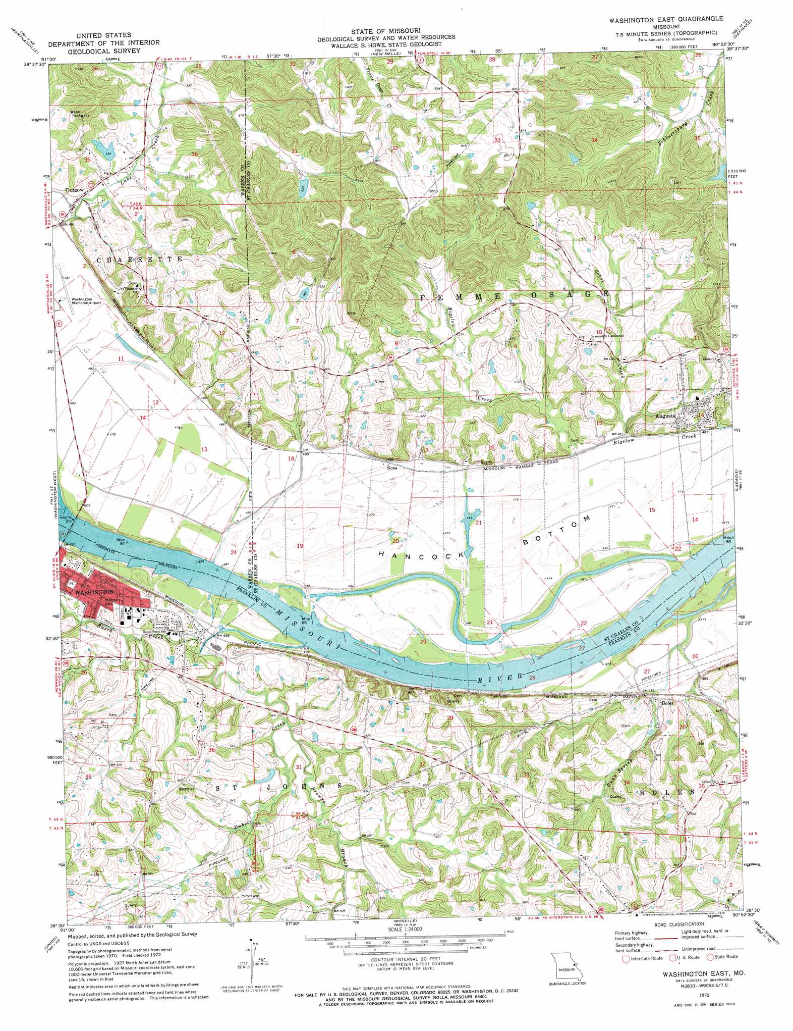
Washington East Topo Map Missouri
To zoom in, hover over the map of Washington East
USGS Topo Quad 38090e8 - 1:24,000 scale
| Topo Map Name: | Washington East |
| USGS Topo Quad ID: | 38090e8 |
| Print Size: | ca. 21 1/4" wide x 27" high |
| Southeast Coordinates: | 38.5° N latitude / 90.875° W longitude |
| Map Center Coordinates: | 38.5625° N latitude / 90.9375° W longitude |
| U.S. State: | MO |
| Filename: | o38090e8.jpg |
| Download Map JPG Image: | Washington East topo map 1:24,000 scale |
| Map Type: | Topographic |
| Topo Series: | 7.5´ |
| Map Scale: | 1:24,000 |
| Source of Map Images: | United States Geological Survey (USGS) |
| Alternate Map Versions: |
Washington East MO 1972, updated 1973 Download PDF Buy paper map Washington East MO 2012 Download PDF Buy paper map Washington East MO 2015 Download PDF Buy paper map |
1:24,000 Topo Quads surrounding Washington East
Warrenton |
Wright City |
Foristell |
Wentzville |
O'Fallon |
Treloar |
Marthasville |
New Melle |
Defiance |
Weldon Spring |
New Haven |
Washington West |
Washington East |
Labadie |
Eureka |
Leslie |
Union |
Moselle |
Gray Summit |
Pacific |
Spring Bluff |
Stanton |
Saint Clair |
Lonedell |
Cedar Hill |
> Back to 38090e1 at 1:100,000 scale
> Back to 38090a1 at 1:250,000 scale
> Back to U.S. Topo Maps home
Washington East topo map: Gazetteer
Washington East: Airports
Washington Memorial Airport elevation 148m 485′Washington East: Bends
Hancock Bottom elevation 144m 472′Hinckley Bend elevation 138m 452′
Washington East: Dams
Aholt Farms East Lake Lower Dam elevation 163m 534′Bair Lake Dam elevation 178m 583′
Green Valley Farm Dam elevation 170m 557′
Hinnah Lake Dam elevation 196m 643′
Hoblitzell Lower Lake Dam elevation 161m 528′
Hoblitzell Upper Lake Dam elevation 172m 564′
Jim Bair Dam elevation 191m 626′
Mononame 456 Dam elevation 150m 492′
Poepsel Farm Lake Dam elevation 155m 508′
Robert Schultehenrich Dam elevation 184m 603′
Sadler Lake Dam elevation 162m 531′
Siem Lake Dam elevation 164m 538′
Soloman Lake Dam elevation 193m 633′
Sprague Lake Dam elevation 150m 492′
Struckhoff Lake Section 11 Dam elevation 160m 524′
Struckhoffs Dam elevation 168m 551′
Voelkerding Lake Dam elevation 163m 534′
Willson Lake Dam elevation 157m 515′
Washington East: Populated Places
Augusta elevation 171m 561′Boles elevation 152m 498′
Dartmound (historical) elevation 149m 488′
Dutzow elevation 149m 488′
Nona elevation 151m 495′
South Point (historical) elevation 164m 538′
Washington East: Post Offices
Augusta Post Office elevation 170m 557′Washington East: Reservoirs
Bair Lake elevation 191m 626′Green Valley Farm Pond elevation 170m 557′
Hinnah Lake elevation 196m 643′
Hoblitzell Lake elevation 172m 564′
John Sprague Reservoir elevation 150m 492′
Robert Knoerschild Lake elevation 160m 524′
Sadler Lake elevation 162m 531′
Schulthhenrich Lake elevation 184m 603′
Struckhoffs Lake elevation 168m 551′
Voelkerding Lake elevation 163m 534′
Washington East: Streams
Browns Branch elevation 146m 479′Busch Creek elevation 144m 472′
Charrette Creek elevation 144m 472′
Dubois Creek elevation 148m 485′
Dunn Spring Creek elevation 144m 472′
Sehrt Creek elevation 144m 472′
Washington East digital topo map on disk
Buy this Washington East topo map showing relief, roads, GPS coordinates and other geographical features, as a high-resolution digital map file on DVD: