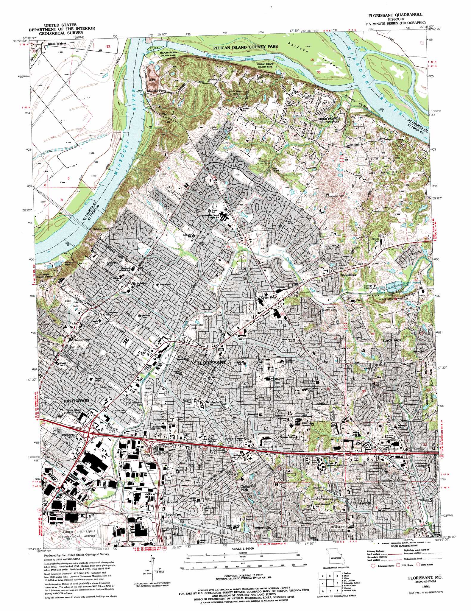
Florissant Topo Map Missouri
To zoom in, hover over the map of Florissant
USGS Topo Quad 38090g3 - 1:24,000 scale
| Topo Map Name: | Florissant |
| USGS Topo Quad ID: | 38090g3 |
| Print Size: | ca. 21 1/4" wide x 27" high |
| Southeast Coordinates: | 38.75° N latitude / 90.25° W longitude |
| Map Center Coordinates: | 38.8125° N latitude / 90.3125° W longitude |
| U.S. State: | MO |
| Filename: | o38090g3.jpg |
| Download Map JPG Image: | Florissant topo map 1:24,000 scale |
| Map Type: | Topographic |
| Topo Series: | 7.5´ |
| Map Scale: | 1:24,000 |
| Source of Map Images: | United States Geological Survey (USGS) |
| Alternate Map Versions: |
Florissant MO 1935 Download PDF Buy paper map Florissant MO 1954, updated 1959 Download PDF Buy paper map Florissant MO 1954, updated 1965 Download PDF Buy paper map Florissant MO 1954, updated 1969 Download PDF Buy paper map Florissant MO 1954, updated 1975 Download PDF Buy paper map Florissant MO 1954, updated 1982 Download PDF Buy paper map Florissant MO 1994, updated 1994 Download PDF Buy paper map Florissant MO 1998, updated 1999 Download PDF Buy paper map Florissant MO 2012 Download PDF Buy paper map Florissant MO 2015 Download PDF Buy paper map |
1:24,000 Topo Quads surrounding Florissant
Nutwood |
Otterville |
Jerseyville South |
Brighton |
Shipman |
Brussels |
Grafton |
Elsah |
Alton |
Bethalto |
Kampville |
Saint Charles |
Florissant |
Columbia Bottom |
Wood River |
Chesterfield |
Creve Coeur |
Clayton |
Granite City |
Monks Mound |
Manchester |
Kirkwood |
Webster Groves |
Cahokia |
French Village |
> Back to 38090e1 at 1:100,000 scale
> Back to 38090a1 at 1:250,000 scale
> Back to U.S. Topo Maps home
Florissant topo map: Gazetteer
Florissant: Areas
Common Field of Saint Ferdinand (historical) elevation 161m 528′Sinks elevation 163m 534′
Florissant: Crossings
Interchange 10A and 10B elevation 172m 564′Interchange 25A and 25B elevation 159m 521′
Interchange 26A elevation 161m 528′
Interchange 26B elevation 170m 557′
Interchange 27 elevation 170m 557′
Interchange 28 elevation 179m 587′
Interchange 29 elevation 178m 583′
Interchange 30B elevation 152m 498′
Interchange 9C elevation 162m 531′
Florissant: Guts
Car of Commerce Chute elevation 126m 413′Florissant: Parks
Bangert Park elevation 161m 528′Houdershell Park elevation 169m 554′
Jeske Park elevation 158m 518′
Kiel Park elevation 138m 452′
Kock Park elevation 177m 580′
Saint Ferdinand Commons (historical) elevation 167m 547′
Florissant: Populated Places
Berkeley elevation 164m 538′Black Jack elevation 183m 600′
Black Walnut elevation 133m 436′
Calverton Park elevation 189m 620′
Cross Keys elevation 164m 538′
Florissant elevation 175m 574′
Hazelwood elevation 171m 561′
La Charbonniere (historical) elevation 164m 538′
Musicks Ferry elevation 137m 449′
Shoveltown elevation 168m 551′
Florissant: Post Offices
Carr Post Office elevation 169m 554′Florissant Post Office elevation 158m 518′
Hazlewood Post Office elevation 166m 544′
Florissant: Streams
Mill Creek elevation 125m 410′Florissant: Valleys
Possum Hollow elevation 131m 429′Florissant digital topo map on disk
Buy this Florissant topo map showing relief, roads, GPS coordinates and other geographical features, as a high-resolution digital map file on DVD: