Wentzville Topo Map Missouri
To zoom in, hover over the map of Wentzville
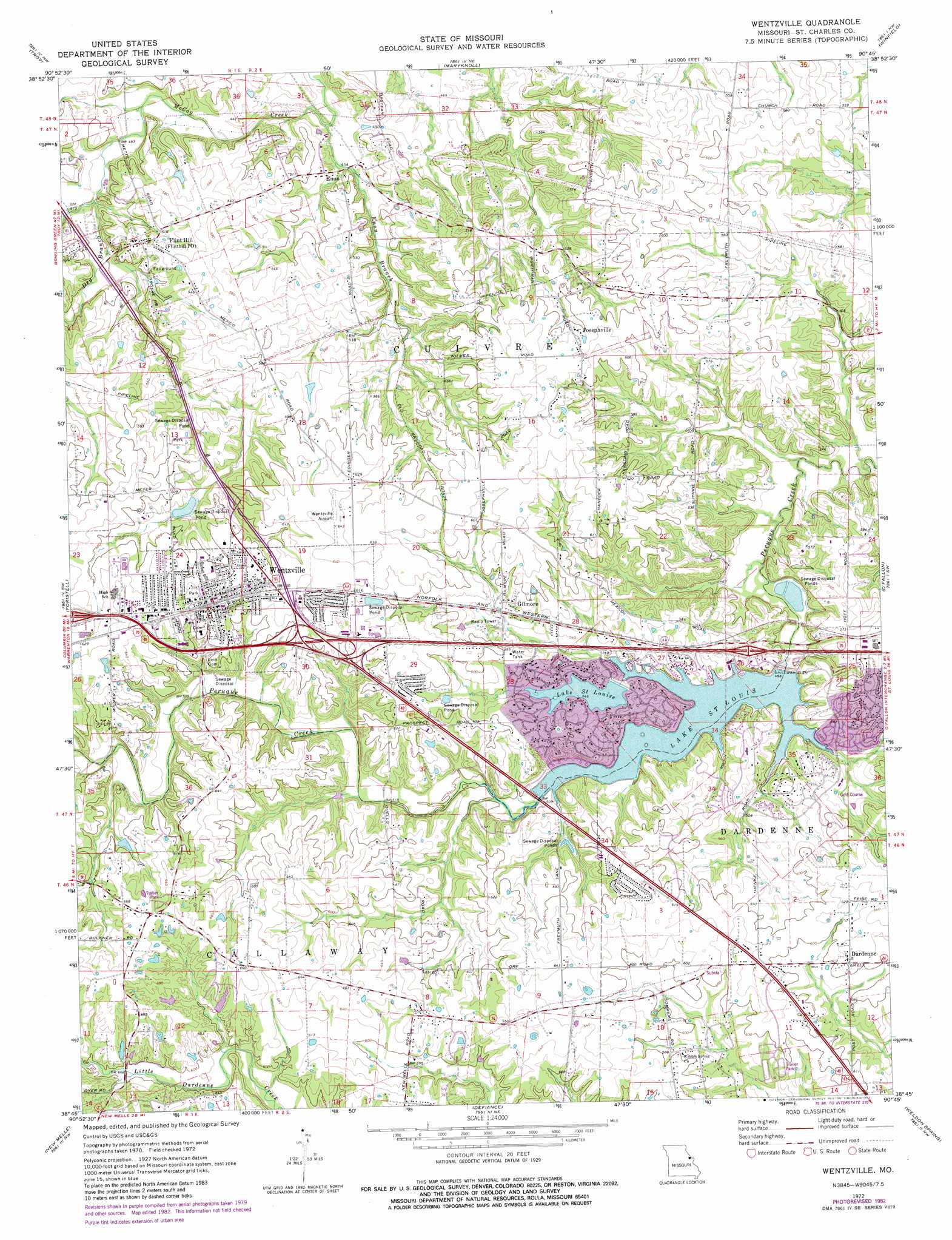
USGS Topo Quad 38090g7 - 1:24,000 scale
| Topo Map Name: | Wentzville |
| USGS Topo Quad ID: | 38090g7 |
| Print Size: | ca. 21 1/4" wide x 27" high |
| Southeast Coordinates: | 38.75° N latitude / 90.75° W longitude |
| Map Center Coordinates: | 38.8125° N latitude / 90.8125° W longitude |
| U.S. State: | MO |
| Filename: | o38090g7.jpg |
| Download Map JPG Image: | Wentzville topo map 1:24,000 scale |
| Map Type: | Topographic |
| Topo Series: | 7.5´ |
| Map Scale: | 1:24,000 |
| Source of Map Images: | United States Geological Survey (USGS) |
| Alternate Map Versions: |
Wentzville MO 1972, updated 1973 Download PDF Buy paper map Wentzville MO 1972, updated 1982 Download PDF Buy paper map Wentzville MO 1979, updated 1980 Download PDF Buy paper map Wentzville MO 2000, updated 2003 Download PDF Buy paper map Wentzville MO 2012 Download PDF Buy paper map Wentzville MO 2015 Download PDF Buy paper map |
1:24,000 Topo Quads surrounding Wentzville
Silex |
Okete |
Luckett Ridge |
Foley |
Nutwood |
Warrenton Ne |
Troy |
Maryknoll |
Winfield |
Brussels |
Wright City |
Foristell |
Wentzville |
O'Fallon |
Kampville |
Marthasville |
New Melle |
Defiance |
Weldon Spring |
Chesterfield |
Washington West |
Washington East |
Labadie |
Eureka |
Manchester |
> Back to 38090e1 at 1:100,000 scale
> Back to 38090a1 at 1:250,000 scale
> Back to U.S. Topo Maps home
Wentzville topo map: Gazetteer
Wentzville: Airports
Strutman Field elevation 190m 623′Wentzville Airport (historical) elevation 195m 639′
Wentzville: Crossings
Interchange 214 elevation 171m 561′Wentzville: Dams
Citizens Mortgage Investment Corporation Section 36 Dam elevation 187m 613′Clement Lake Dam elevation 189m 620′
Lake Saint Louis Dam elevation 151m 495′
Lake Sainte Louise Dam elevation 166m 544′
McNair Lake Dam elevation 158m 518′
New Melle Lake Estates Dam elevation 203m 666′
Wentzville: Populated Places
Dardenne elevation 187m 613′Enon elevation 140m 459′
Flint Hill elevation 167m 547′
Gilmore elevation 176m 577′
Josephville elevation 189m 620′
Lake Saint Louis elevation 172m 564′
Wentzville elevation 190m 623′
Wentzville: Reservoirs
Lake Saint Louis elevation 151m 495′Lake Saint Louise elevation 166m 544′
Lake Sainte Louise elevation 166m 544′
Wentzville: Springs
Silver Spring elevation 157m 515′Wentzville: Streams
Dry Branch elevation 139m 456′Enon Branch elevation 134m 439′
Silver Spring Creek elevation 147m 482′
Wentzville digital topo map on disk
Buy this Wentzville topo map showing relief, roads, GPS coordinates and other geographical features, as a high-resolution digital map file on DVD: