Bethalto Topo Map Illinois
To zoom in, hover over the map of Bethalto
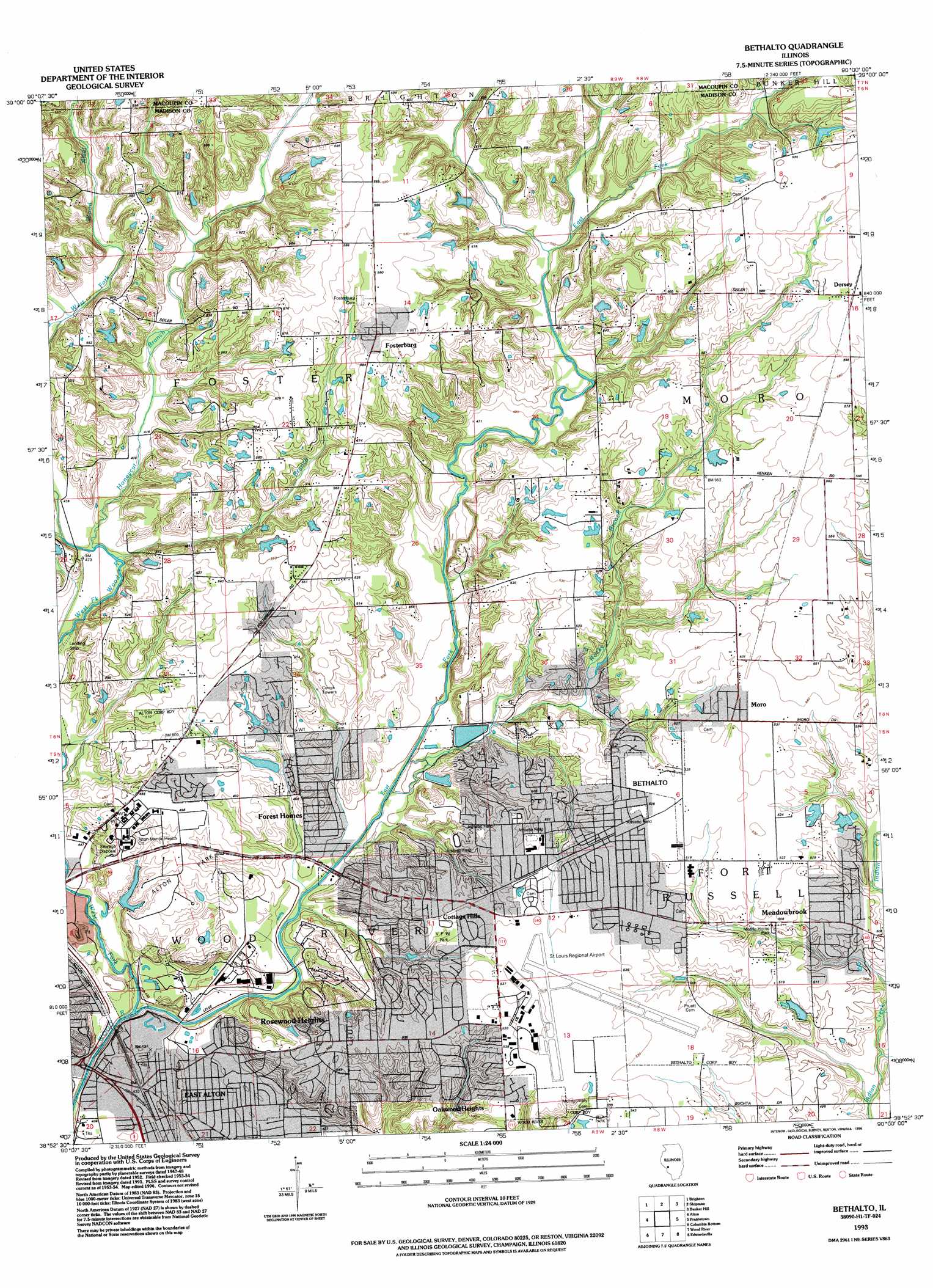
USGS Topo Quad 38090h1 - 1:24,000 scale
| Topo Map Name: | Bethalto |
| USGS Topo Quad ID: | 38090h1 |
| Print Size: | ca. 21 1/4" wide x 27" high |
| Southeast Coordinates: | 38.875° N latitude / 90° W longitude |
| Map Center Coordinates: | 38.9375° N latitude / 90.0625° W longitude |
| U.S. State: | IL |
| Filename: | o38090h1.jpg |
| Download Map JPG Image: | Bethalto topo map 1:24,000 scale |
| Map Type: | Topographic |
| Topo Series: | 7.5´ |
| Map Scale: | 1:24,000 |
| Source of Map Images: | United States Geological Survey (USGS) |
| Alternate Map Versions: |
Bethalto IL 1949 Download PDF Buy paper map Bethalto IL 1954, updated 1959 Download PDF Buy paper map Bethalto IL 1954, updated 1969 Download PDF Buy paper map Bethalto IL 1954, updated 1975 Download PDF Buy paper map Bethalto IL 1954, updated 1990 Download PDF Buy paper map Bethalto IL 1954, updated 1993 Download PDF Buy paper map Bethalto IL 1993, updated 1996 Download PDF Buy paper map Bethalto IL 2012 Download PDF Buy paper map Bethalto IL 2015 Download PDF Buy paper map |
1:24,000 Topo Quads surrounding Bethalto
Jerseyville North |
Medora |
Summerville |
Plainview |
Gillespie North |
Jerseyville South |
Brighton |
Shipman |
Bunker Hill |
Gillespie South |
Elsah |
Alton |
Bethalto |
Prairietown |
Worden |
Florissant |
Columbia Bottom |
Wood River |
Edwardsville |
Marine |
Clayton |
Granite City |
Monks Mound |
Collinsville |
Saint Jacob |
> Back to 38090e1 at 1:100,000 scale
> Back to 38090a1 at 1:250,000 scale
> Back to U.S. Topo Maps home
Bethalto topo map: Gazetteer
Bethalto: Airports
Saint Louis Regional Airport elevation 163m 534′Bethalto: Dams
Downing Pond Dam elevation 168m 551′Paradise Lake Dam elevation 144m 472′
Bethalto: Parks
Alton Park elevation 147m 482′Belk Park elevation 164m 538′
Bethalto Park elevation 160m 524′
Khoury League Park elevation 162m 531′
Kutter Park elevation 141m 462′
Van Preter Park elevation 134m 439′
Veterans of Foreign Wars Park elevation 155m 508′
Wood River Township Park elevation 139m 456′
Bethalto: Populated Places
Bethalto elevation 160m 524′Cottage Hills elevation 156m 511′
Dorsey elevation 179m 587′
East Alton elevation 132m 433′
Forest Homes elevation 152m 498′
Fosterburg elevation 177m 580′
Meadowbrook elevation 156m 511′
Moro elevation 162m 531′
Oakwood Heights elevation 163m 534′
Rosedale elevation 163m 534′
Rosewood Heights elevation 167m 547′
Woods elevation 154m 505′
Bethalto: Post Offices
Bethalto Post Office elevation 159m 521′Cottage Hills Post Office elevation 156m 511′
Moro Post Office elevation 162m 531′
Bethalto: Reservoirs
Downing Pond elevation 168m 551′Paridise Lake elevation 144m 472′
Bethalto: Streams
East Fork Wood River elevation 128m 419′Honeycut Branch elevation 142m 465′
Lick Branch elevation 142m 465′
Rocky Branch elevation 133m 436′
West Fork Wood River elevation 128m 419′
Bethalto digital topo map on disk
Buy this Bethalto topo map showing relief, roads, GPS coordinates and other geographical features, as a high-resolution digital map file on DVD: