Alton Topo Map Illinois
To zoom in, hover over the map of Alton
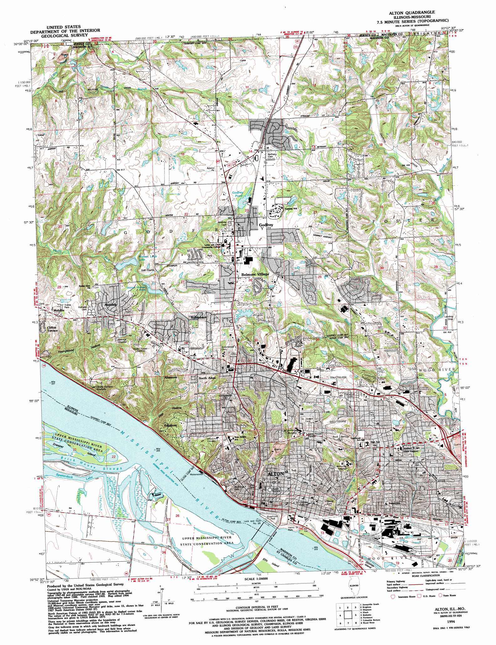
USGS Topo Quad 38090h2 - 1:24,000 scale
| Topo Map Name: | Alton |
| USGS Topo Quad ID: | 38090h2 |
| Print Size: | ca. 21 1/4" wide x 27" high |
| Southeast Coordinates: | 38.875° N latitude / 90.125° W longitude |
| Map Center Coordinates: | 38.9375° N latitude / 90.1875° W longitude |
| U.S. States: | IL, MO |
| Filename: | o38090h2.jpg |
| Download Map JPG Image: | Alton topo map 1:24,000 scale |
| Map Type: | Topographic |
| Topo Series: | 7.5´ |
| Map Scale: | 1:24,000 |
| Source of Map Images: | United States Geological Survey (USGS) |
| Alternate Map Versions: |
Alton IL 1948, updated 1954 Download PDF Buy paper map Alton IL 1950 Download PDF Buy paper map Alton IL 1950 Download PDF Buy paper map Alton IL 1954, updated 1959 Download PDF Buy paper map Alton IL 1954, updated 1969 Download PDF Buy paper map Alton IL 1954, updated 1975 Download PDF Buy paper map Alton IL 1954, updated 1986 Download PDF Buy paper map Alton IL 1994, updated 1994 Download PDF Buy paper map Alton IL 2012 Download PDF Buy paper map Alton IL 2015 Download PDF Buy paper map |
1:24,000 Topo Quads surrounding Alton
Boyer Creek |
Jerseyville North |
Medora |
Summerville |
Plainview |
Otterville |
Jerseyville South |
Brighton |
Shipman |
Bunker Hill |
Grafton |
Elsah |
Alton |
Bethalto |
Prairietown |
Saint Charles |
Florissant |
Columbia Bottom |
Wood River |
Edwardsville |
Creve Coeur |
Clayton |
Granite City |
Monks Mound |
Collinsville |
> Back to 38090e1 at 1:100,000 scale
> Back to 38090a1 at 1:250,000 scale
> Back to U.S. Topo Maps home
Alton topo map: Gazetteer
Alton: Airports
Alton Memorial Hospital Heliport elevation 161m 528′Hammet Airport elevation 178m 583′
Saint Anthonys Heliport elevation 171m 561′
Saint Clares Hospital Heliport elevation 152m 498′
Alton: Bridges
Clark Bridge elevation 127m 416′Clark Bridge elevation 127m 416′
Alton: Dams
Alton Twin Lakes South Dam elevation 153m 501′Alton-Woodriver Sportsmens Reservoir Dam elevation 178m 583′
Godfrey Pond Dam elevation 183m 600′
Lock and Dam Number 26 elevation 127m 416′
Lock and Dam Number Twenty-six elevation 127m 416′
Warren Levis Lake Dam elevation 156m 511′
Wilkinson Pond Dam elevation 165m 541′
Alton: Lakes
Spatterdock Lake elevation 127m 416′Alton: Mines
Alby Quarry elevation 146m 479′Alton Mine elevation 131m 429′
Lohr Quarry elevation 140m 459′
Alton: Parks
Adams Park elevation 187m 613′Haskell Park elevation 171m 561′
Henry Street Park elevation 131m 429′
John M Olin Nature Preserve elevation 159m 521′
Lovejoy State Memorial elevation 162m 531′
Olin Park elevation 183m 600′
Public Square elevation 156m 511′
Riverfront Park elevation 130m 426′
Riverview Park elevation 174m 570′
Rock Springs Park elevation 171m 561′
Salu Park elevation 168m 551′
Seminary Square elevation 165m 541′
Alton: Populated Places
Alandale elevation 183m 600′Altamont elevation 195m 639′
Alton elevation 150m 492′
Belmont Village elevation 186m 610′
Fairmont elevation 190m 623′
Godfrey elevation 186m 610′
Melville elevation 185m 606′
Milton elevation 158m 518′
North Alton elevation 196m 643′
Quatoga Bluff elevation 161m 528′
Sloan elevation 161m 528′
Southmoor elevation 177m 580′
Upper Alton elevation 166m 544′
Alton: Post Offices
Godfrey Post Office elevation 186m 610′Upper Alton Post Office elevation 166m 544′
Alton: Reservoirs
Alton Lake elevation 127m 416′Alton Twin Lakes South Lake elevation 153m 501′
Alton-Woodriver Sportsmens Reservoir elevation 178m 583′
Godfrey Pond elevation 183m 600′
Warren Levis Lake elevation 156m 511′
Wilkinson Pond elevation 165m 541′
Alton: Streams
Black Creek elevation 134m 439′Brick House Slough elevation 127m 416′
Coal Branch elevation 145m 475′
Rock Creek elevation 136m 446′
Shields Branch elevation 130m 426′
South Branch Little Piasa Creek elevation 137m 449′
Alton: Valleys
Hop Hollow elevation 127m 416′Youngblood Hollow elevation 130m 426′
Alton digital topo map on disk
Buy this Alton topo map showing relief, roads, GPS coordinates and other geographical features, as a high-resolution digital map file on DVD: