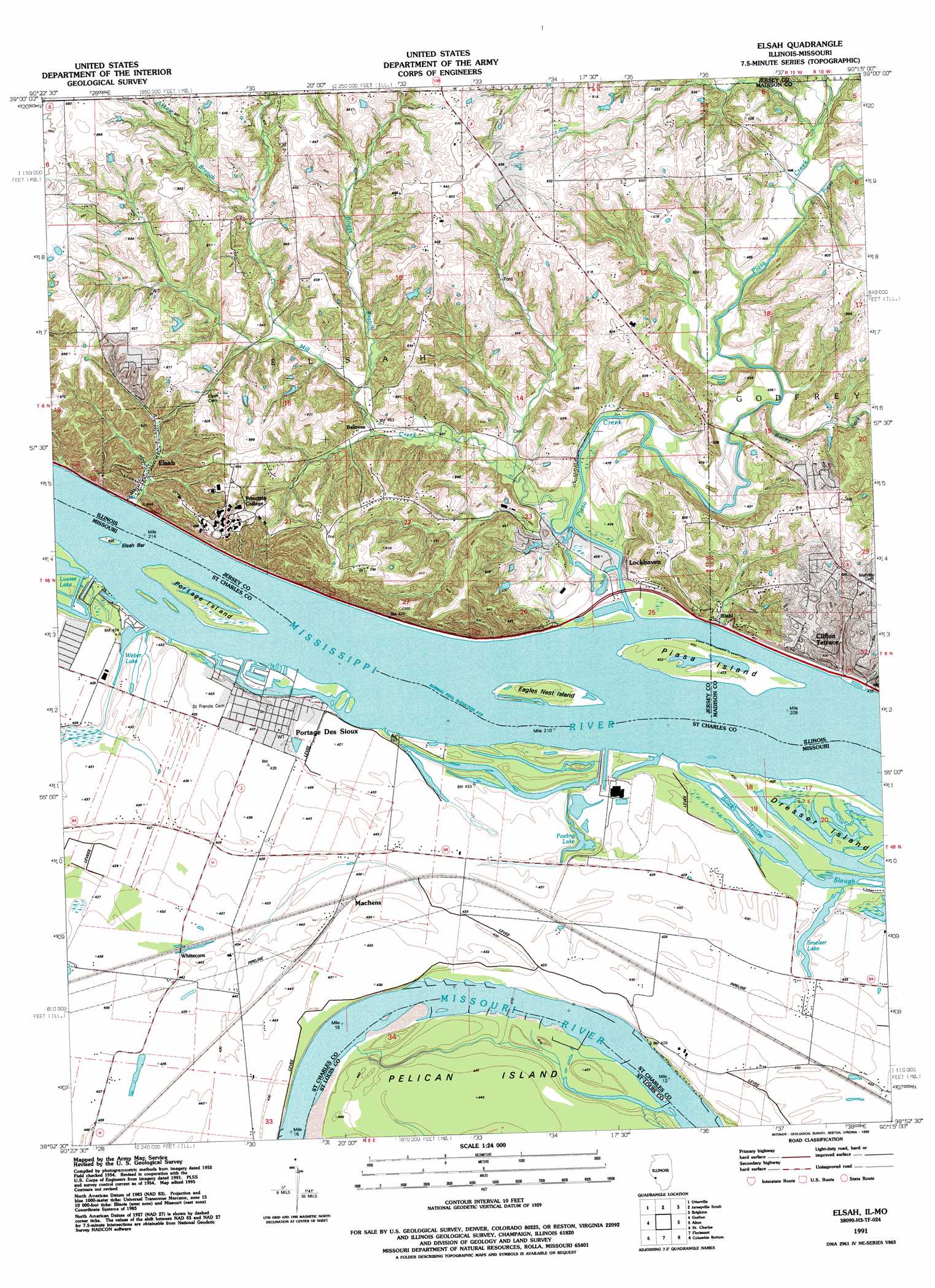
Elsah Topo Map Missouri
To zoom in, hover over the map of Elsah
USGS Topo Quad 38090h3 - 1:24,000 scale
| Topo Map Name: | Elsah |
| USGS Topo Quad ID: | 38090h3 |
| Print Size: | ca. 21 1/4" wide x 27" high |
| Southeast Coordinates: | 38.875° N latitude / 90.25° W longitude |
| Map Center Coordinates: | 38.9375° N latitude / 90.3125° W longitude |
| U.S. States: | MO, IL |
| Filename: | o38090h3.jpg |
| Download Map JPG Image: | Elsah topo map 1:24,000 scale |
| Map Type: | Topographic |
| Topo Series: | 7.5´ |
| Map Scale: | 1:24,000 |
| Source of Map Images: | United States Geological Survey (USGS) |
| Alternate Map Versions: |
Elsah IL 1954, updated 1959 Download PDF Buy paper map Elsah IL 1954, updated 1969 Download PDF Buy paper map Elsah IL 1954, updated 1975 Download PDF Buy paper map Elsah IL 1991, updated 1995 Download PDF Buy paper map Elsah IL 2012 Download PDF Buy paper map Elsah IL 2015 Download PDF Buy paper map |
1:24,000 Topo Quads surrounding Elsah
Hardin |
Boyer Creek |
Jerseyville North |
Medora |
Summerville |
Nutwood |
Otterville |
Jerseyville South |
Brighton |
Shipman |
Brussels |
Grafton |
Elsah |
Alton |
Bethalto |
Kampville |
Saint Charles |
Florissant |
Columbia Bottom |
Wood River |
Chesterfield |
Creve Coeur |
Clayton |
Granite City |
Monks Mound |
> Back to 38090e1 at 1:100,000 scale
> Back to 38090a1 at 1:250,000 scale
> Back to U.S. Topo Maps home
Elsah topo map: Gazetteer
Elsah: Capes
Williams Point elevation 128m 419′Elsah: Dams
Smith Lake Dam elevation 179m 587′Elsah: Islands
Dresser Island elevation 127m 416′Eagles Nest Island elevation 128m 419′
Elsah Bar elevation 127m 416′
Pelican Island elevation 130m 426′
Piasa Island elevation 128m 419′
Portage Island elevation 129m 423′
Elsah: Lakes
Poeling Lake elevation 127m 416′Smelzer Lake elevation 128m 419′
Weber Lake elevation 127m 416′
Elsah: Parks
Common Fields of Portage des Sioux elevation 135m 442′Elsah Historic District elevation 128m 419′
Elsah: Populated Places
Beltrees elevation 138m 452′Clifton Terrace elevation 133m 436′
Elsah elevation 132m 433′
Lockhaven elevation 130m 426′
Machens elevation 132m 433′
Piasa Hills elevation 171m 561′
Portage Des Sioux elevation 132m 433′
Riehl elevation 131m 429′
Whitecorn elevation 133m 436′
Elsah: Post Offices
Elsah Post Office elevation 132m 433′Portage Des Sioux Post Office elevation 132m 433′
Elsah: Reservoirs
Smith Lake elevation 179m 587′Elsah: Streams
Askew Branch elevation 155m 508′Briggs Branch elevation 132m 433′
Little Piasa Creek elevation 134m 439′
Mill Creek elevation 127m 416′
Piasa Creek elevation 128m 419′
Rocky Fork elevation 127m 416′
Elsah digital topo map on disk
Buy this Elsah topo map showing relief, roads, GPS coordinates and other geographical features, as a high-resolution digital map file on DVD: