Onondaga Cave Topo Map Missouri
To zoom in, hover over the map of Onondaga Cave
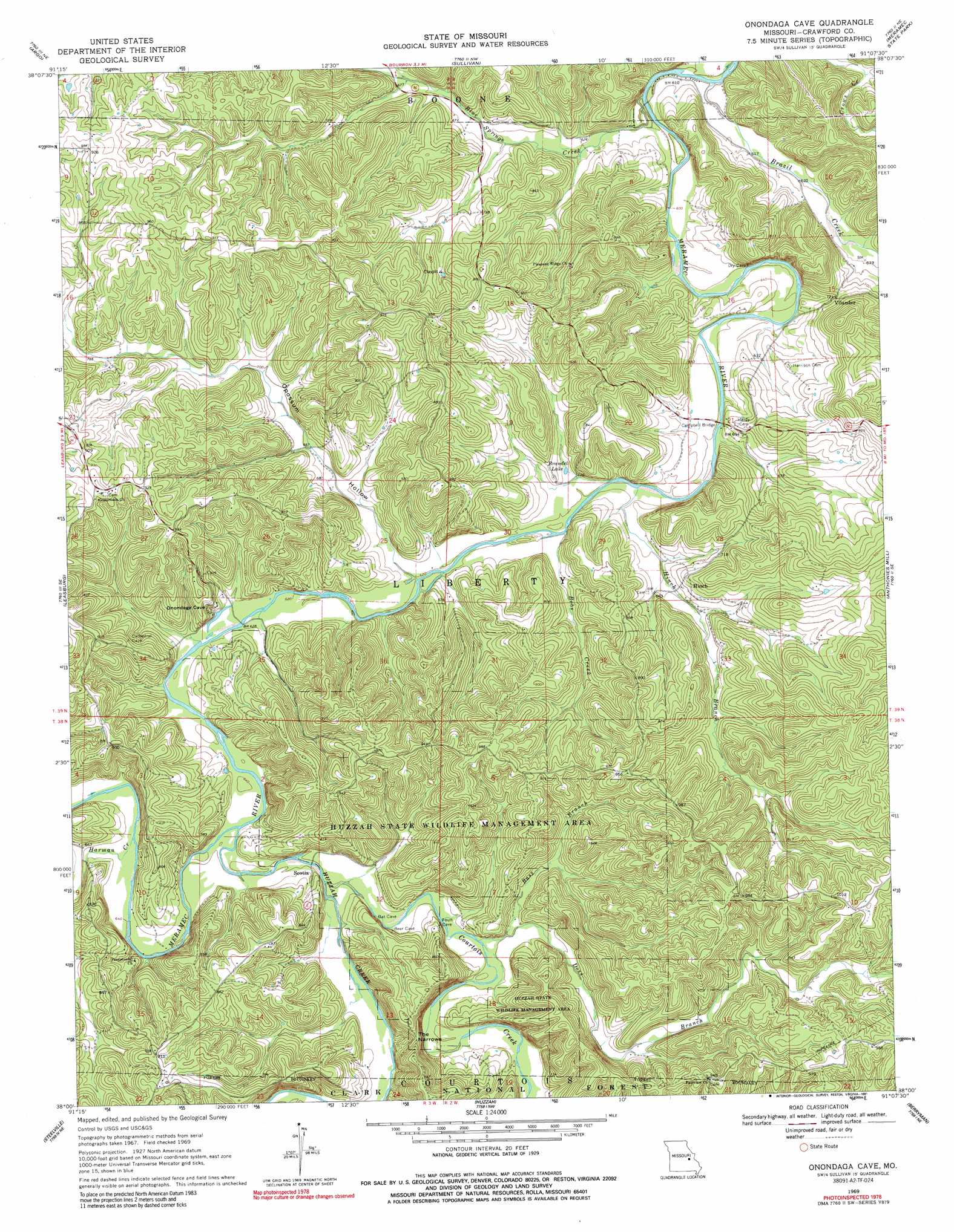
USGS Topo Quad 38091a2 - 1:24,000 scale
| Topo Map Name: | Onondaga Cave |
| USGS Topo Quad ID: | 38091a2 |
| Print Size: | ca. 21 1/4" wide x 27" high |
| Southeast Coordinates: | 38° N latitude / 91.125° W longitude |
| Map Center Coordinates: | 38.0625° N latitude / 91.1875° W longitude |
| U.S. State: | MO |
| Filename: | o38091a2.jpg |
| Download Map JPG Image: | Onondaga Cave topo map 1:24,000 scale |
| Map Type: | Topographic |
| Topo Series: | 7.5´ |
| Map Scale: | 1:24,000 |
| Source of Map Images: | United States Geological Survey (USGS) |
| Alternate Map Versions: |
Onondaga Cave MO 1969, updated 1971 Download PDF Buy paper map Onondaga Cave MO 1969, updated 1976 Download PDF Buy paper map Onondaga Cave MO 1969, updated 1991 Download PDF Buy paper map Onondaga Cave MO 2012 Download PDF Buy paper map Onondaga Cave MO 2015 Download PDF Buy paper map |
| FStopo: | US Forest Service topo Onondaga Cave is available: Download FStopo PDF Download FStopo TIF |
1:24,000 Topo Quads surrounding Onondaga Cave
Owensville East |
Strain |
Spring Bluff |
Stanton |
Saint Clair |
Oak Hill |
Argo |
Sullivan |
Meramec State Park |
Cyclone Hollow |
Cuba |
Leasburg |
Onondaga Cave |
Anthonies Mill |
Ebo |
Indian Springs |
Steelville |
Huzzah |
Berryman |
Shirley |
Cook Station |
Cherryville |
Davisville |
Courtois |
Palmer |
> Back to 38091a1 at 1:100,000 scale
> Back to 38090a1 at 1:250,000 scale
> Back to U.S. Topo Maps home
Onondaga Cave topo map: Gazetteer
Onondaga Cave: Bridges
Campbell Bridge elevation 189m 620′Hog Trough Bridge elevation 183m 600′
Onondaga Cave: Dams
Baumstark Lake Dam elevation 219m 718′Number 410 Dam elevation 296m 971′
Opossum Hollow Dam elevation 208m 682′
Onondaga Cave: Gaps
The Narrows elevation 248m 813′Onondaga Cave: Lakes
Brandel Lake elevation 193m 633′Onondaga Cave: Mines
Bleeding Hill Copper Mines elevation 254m 833′Bleeding Hill Iron Bank elevation 307m 1007′
Hinch Copper Mine elevation 240m 787′
Hinchs Lead Diggings elevation 251m 823′
Hobo Iron and Sulphur Mines elevation 226m 741′
Isgreeg Lead Mine elevation 219m 718′
Knox Number Two Iron Mine elevation 208m 682′
Lockhart Lead Mine elevation 224m 734′
Ransom Lead Diggings elevation 292m 958′
Rich Hill Lead Diggings elevation 256m 839′
Rives Copper Mine elevation 273m 895′
Rutledge Lead Diggings elevation 201m 659′
Scotia Number One Iron Bank elevation 211m 692′
Scotia Number Two Iron Bank elevation 225m 738′
Onondaga Cave: Parks
Huzzah Conservation Area elevation 262m 859′Iroquois Park elevation 244m 800′
Onondaga Cave: Populated Places
Crossroads elevation 283m 928′Harrison Mills elevation 212m 695′
Hinch elevation 229m 751′
Scotia elevation 200m 656′
Vilander elevation 220m 721′
Onondaga Cave: Reservoirs
Baumstark Lake elevation 219m 718′Fred Weber Lake elevation 208m 682′
Onondaga Cave: Streams
Bass Branch elevation 202m 662′Bessen River elevation 195m 639′
Blue Springs Creek elevation 183m 600′
Bobs Creek elevation 189m 620′
Bouse Creek elevation 274m 898′
Brazil Creek elevation 183m 600′
Courtois Creek elevation 194m 636′
Doss Branch elevation 201m 659′
Harman Creek elevation 201m 659′
Hinch Branch elevation 189m 620′
Hobo Branch elevation 194m 636′
Huzzah Creek elevation 194m 636′
Kelly Branch elevation 189m 620′
Onondaga Cave: Summits
Fair View Hill elevation 287m 941′Lea Hill elevation 288m 944′
Onondaga Cave: Valleys
Opossum Hollow elevation 189m 620′Onondaga Cave digital topo map on disk
Buy this Onondaga Cave topo map showing relief, roads, GPS coordinates and other geographical features, as a high-resolution digital map file on DVD: