Meramec State Park Topo Map Missouri
To zoom in, hover over the map of Meramec State Park
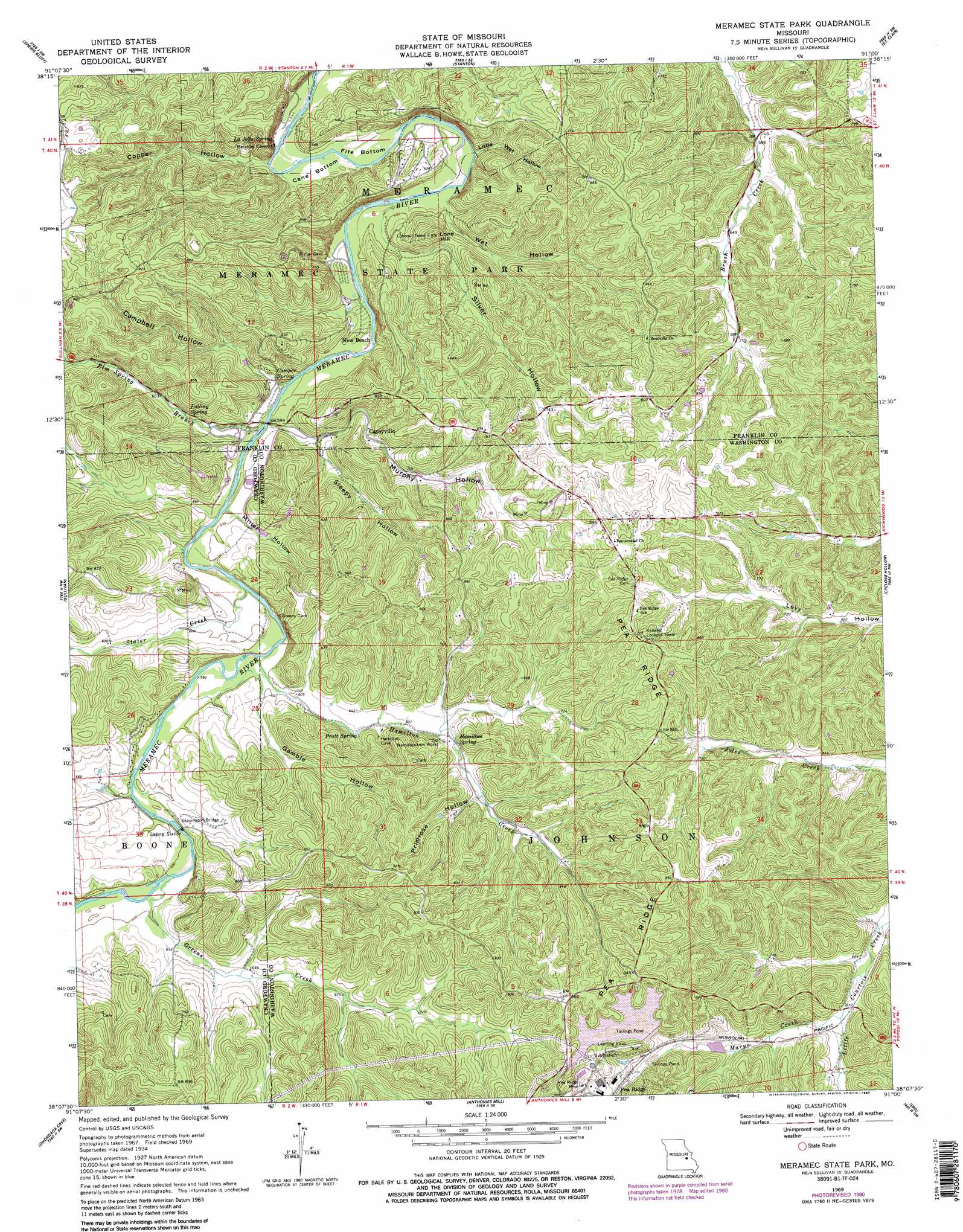
USGS Topo Quad 38091b1 - 1:24,000 scale
| Topo Map Name: | Meramec State Park |
| USGS Topo Quad ID: | 38091b1 |
| Print Size: | ca. 21 1/4" wide x 27" high |
| Southeast Coordinates: | 38.125° N latitude / 91° W longitude |
| Map Center Coordinates: | 38.1875° N latitude / 91.0625° W longitude |
| U.S. State: | MO |
| Filename: | o38091b1.jpg |
| Download Map JPG Image: | Meramec State Park topo map 1:24,000 scale |
| Map Type: | Topographic |
| Topo Series: | 7.5´ |
| Map Scale: | 1:24,000 |
| Source of Map Images: | United States Geological Survey (USGS) |
| Alternate Map Versions: |
Meramec State Park MO 1934, updated 1962 Download PDF Buy paper map Meramec State Park MO 1934, updated 1964 Download PDF Buy paper map Meramec State Park MO 1937 Download PDF Buy paper map Meramec State Park MO 1969, updated 1971 Download PDF Buy paper map Meramec State Park MO 1969, updated 1977 Download PDF Buy paper map Meramec State Park MO 1969, updated 1980 Download PDF Buy paper map Meramec State Park MO 1969, updated 1987 Download PDF Buy paper map Meramec State Park MO 1969, updated 1987 Download PDF Buy paper map Meramec State Park MO 2012 Download PDF Buy paper map Meramec State Park MO 2015 Download PDF Buy paper map |
1:24,000 Topo Quads surrounding Meramec State Park
Gerald |
Leslie |
Union |
Moselle |
Gray Summit |
Strain |
Spring Bluff |
Stanton |
Saint Clair |
Lonedell |
Argo |
Sullivan |
Meramec State Park |
Cyclone Hollow |
Richwoods |
Leasburg |
Onondaga Cave |
Anthonies Mill |
Ebo |
Old Mines |
Steelville |
Huzzah |
Berryman |
Shirley |
Potosi |
> Back to 38091a1 at 1:100,000 scale
> Back to 38090a1 at 1:250,000 scale
> Back to U.S. Topo Maps home
Meramec State Park topo map: Gazetteer
Meramec State Park: Bends
Cane Bottom elevation 171m 561′Fife Bottom elevation 171m 561′
Meramec State Park: Bridges
Sappington Bridge elevation 177m 580′Meramec State Park: Dams
Moosehorn Lake Dam elevation 233m 764′Number 588 Dam elevation 235m 770′
Pea Ridge Mine Dam elevation 241m 790′
Meramec State Park: Gaps
Persimmon Gap elevation 243m 797′Meramec State Park: Mines
Blanton Copper Mine elevation 253m 830′Blanton Limonite Bank elevation 205m 672′
Blanton Specular Iron Bank elevation 225m 738′
Copper Hill Mine elevation 241m 790′
Hiblers Lead Diggings elevation 190m 623′
Old Copper Hill Iron Bank elevation 206m 675′
Pea Ridge Mine elevation 275m 902′
Primrose Hill Iron Bank elevation 218m 715′
Red Hill Lead Diggings elevation 263m 862′
Sullivan and Bridell Iron Mine elevation 186m 610′
Sullivan Lead Mine elevation 179m 587′
Meramec State Park: Parks
Meramec Conservation Area elevation 219m 718′Meramec State Park: Populated Places
Caseyville elevation 214m 702′Hulsey elevation 287m 941′
Miramiguoa Park elevation 193m 633′
Monday elevation 214m 702′
Pea Ridge elevation 243m 797′
Meramec State Park: Post Offices
Monday Post Office (historical) elevation 214m 702′Meramec State Park: Reservoirs
Meramec Park Lake elevation 175m 574′Moosehorn Lake elevation 233m 764′
Pea Ridge Tailings Pond elevation 241m 790′
Meramec State Park: Ridges
Pea Ridge elevation 288m 944′Meramec State Park: Springs
Camper Spring elevation 177m 580′Falling Spring elevation 191m 626′
Hamilton Spring elevation 198m 649′
La Jolla Spring elevation 229m 751′
Pratt Spring elevation 187m 613′
Meramec State Park: Streams
Beaver Creek elevation 176m 577′Elm Spring Branch elevation 177m 580′
Greens Creek elevation 178m 583′
Hamilton Creek elevation 177m 580′
Marys Creek elevation 202m 662′
Stater Creek elevation 177m 580′
Meramec State Park: Summits
Lone Hill elevation 229m 751′Meramec State Park: Valleys
Campbell Hollow elevation 180m 590′Copper Hollow elevation 176m 577′
Gamble Hollow elevation 178m 583′
Greens Hollow elevation 203m 666′
Little Wet Hollow elevation 171m 561′
Miller Hollow elevation 178m 583′
Murphy Hollow elevation 178m 583′
Primrose Hollow elevation 207m 679′
Silver Hollow elevation 180m 590′
Sleepy Hollow elevation 184m 603′
Wet Hollow elevation 176m 577′
Meramec State Park digital topo map on disk
Buy this Meramec State Park topo map showing relief, roads, GPS coordinates and other geographical features, as a high-resolution digital map file on DVD: