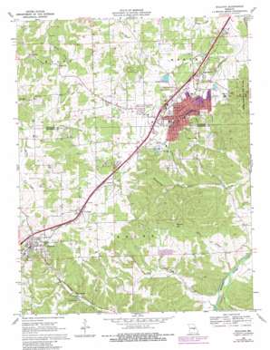
Sullivan Topo Map Missouri
To zoom in, hover over the map of Sullivan
USGS Topo Quad 38091b2 - 1:24,000 scale
| Topo Map Name: | Sullivan |
| USGS Topo Quad ID: | 38091b2 |
| Print Size: | ca. 21 1/4" wide x 27" high |
| Southeast Coordinates: | 38.125° N latitude / 91.125° W longitude |
| Map Center Coordinates: | 38.1875° N latitude / 91.1875° W longitude |
| U.S. State: | MO |
| Filename: | o38091b2.jpg |
| Download Map JPG Image: | Sullivan topo map 1:24,000 scale |
| Map Type: | Topographic |
| Topo Series: | 7.5´ |
| Map Scale: | 1:24,000 |
| Source of Map Images: | United States Geological Survey (USGS) |
| Alternate Map Versions: |
Sullivan MO 1969, updated 1971 Download PDF Buy paper map Sullivan MO 1969, updated 1980 Download PDF Buy paper map Sullivan MO 2012 Download PDF Buy paper map Sullivan MO 2015 Download PDF Buy paper map |
1:24,000 Topo Quads surrounding Sullivan
> Back to 38091a1 at 1:100,000 scale
> Back to 38090a1 at 1:250,000 scale
> Back to U.S. Topo Maps home
Sullivan topo map: Gazetteer
Sullivan: Airports
Sullivan Memorial Airport elevation 295m 967′Sullivan: Dams
City Park Lake Dam elevation 293m 961′Ramstein Lake Dam elevation 291m 954′
Sullivan: Lakes
Bluff Lake elevation 215m 705′Von Hoffman Lake elevation 214m 702′
Sullivan: Mines
Carter Lead Mine elevation 306m 1003′Hibler Lead Diggings elevation 317m 1040′
Isgrigs Lead Diggings elevation 207m 679′
Luke Bluff Lead Mine elevation 216m 708′
Mineral Hill Lead Mines elevation 280m 918′
Romine Lead Mine elevation 267m 875′
Soulard Lead Mine elevation 246m 807′
Williams Lead Mine elevation 234m 767′
Sullivan: Populated Places
Bourbon elevation 287m 941′Elmont elevation 296m 971′
Oak Grove Village elevation 290m 951′
Saint Cloud elevation 291m 954′
Sullivan elevation 299m 980′
West Sullivan elevation 298m 977′
Sullivan: Reservoirs
City Park Lake elevation 293m 961′Ramstein Lake elevation 291m 954′
Sullivan: Springs
Blue Springs elevation 216m 708′Cress Spring elevation 243m 797′
Elm Spring elevation 230m 754′
Sullivan: Streams
Carter Creek elevation 182m 597′Crows Creek elevation 182m 597′
Hyde Branch elevation 182m 597′
Sullivan: Summits
Mineral Hill elevation 329m 1079′Sullivan: Valleys
Bowman Hollow elevation 242m 793′Pump Hollow elevation 233m 764′
Wildcat Hollow elevation 220m 721′
Sullivan digital topo map on disk
Buy this Sullivan topo map showing relief, roads, GPS coordinates and other geographical features, as a high-resolution digital map file on DVD:


