Mokane East Topo Map Missouri
To zoom in, hover over the map of Mokane East
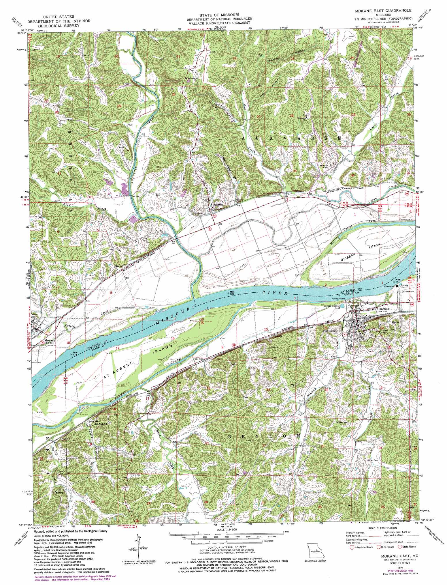
USGS Topo Quad 38091f7 - 1:24,000 scale
| Topo Map Name: | Mokane East |
| USGS Topo Quad ID: | 38091f7 |
| Print Size: | ca. 21 1/4" wide x 27" high |
| Southeast Coordinates: | 38.625° N latitude / 91.75° W longitude |
| Map Center Coordinates: | 38.6875° N latitude / 91.8125° W longitude |
| U.S. State: | MO |
| Filename: | o38091f7.jpg |
| Download Map JPG Image: | Mokane East topo map 1:24,000 scale |
| Map Type: | Topographic |
| Topo Series: | 7.5´ |
| Map Scale: | 1:24,000 |
| Source of Map Images: | United States Geological Survey (USGS) |
| Alternate Map Versions: |
Mokane East MO 1975, updated 1977 Download PDF Buy paper map Mokane East MO 1975, updated 1986 Download PDF Buy paper map Mokane East MO 2000, updated 2003 Download PDF Buy paper map Mokane East MO 2012 Download PDF Buy paper map Mokane East MO 2015 Download PDF Buy paper map |
1:24,000 Topo Quads surrounding Mokane East
Millersburg Ne |
Kingdom City |
Calwood |
Williamsburg |
Montgomery City |
Guthrie |
Fulton |
Reform |
Readsville |
Americus |
New Bloomfield |
Mokane West |
Mokane East |
Morrison |
Gasconade |
Osage City |
Loose Creek |
Luystown |
Fredericksburg |
Pershing |
Westphalia West |
Westphalia East |
Linn |
Cooper Hill |
Coerlisch Ridge |
> Back to 38091e1 at 1:100,000 scale
> Back to 38090a1 at 1:250,000 scale
> Back to U.S. Topo Maps home
Mokane East topo map: Gazetteer
Mokane East: Dams
Miller Lake Dam elevation 159m 521′Mokane East: Guts
Saint Aubert Chute elevation 157m 515′Mokane East: Islands
Binggeli Island elevation 159m 521′Saint Aubert Island elevation 160m 524′
Mokane East: Populated Places
Chamois elevation 164m 538′Mokane elevation 165m 541′
Saint Aubert elevation 166m 544′
Steedman elevation 166m 544′
Mokane East: Reservoirs
Rehard Lake elevation 168m 551′Mokane East: Streams
Auxvasse Creek elevation 161m 528′Blue Creek elevation 158m 518′
Clabber Creek elevation 160m 524′
Collier Creek elevation 161m 528′
Deer Creek elevation 160m 524′
Dooling Creek elevation 160m 524′
East Wing Creek elevation 161m 528′
Grassy Creek elevation 218m 715′
Logan Camp Branch elevation 159m 521′
Mud Creek elevation 156m 511′
Owl Creek elevation 162m 531′
Saint Aubert Creek elevation 163m 534′
Mokane East: Valleys
Hall Hollow elevation 169m 554′Hogpen Hollow elevation 179m 587′
K Y Spring Hollow elevation 173m 567′
Mokane East digital topo map on disk
Buy this Mokane East topo map showing relief, roads, GPS coordinates and other geographical features, as a high-resolution digital map file on DVD: