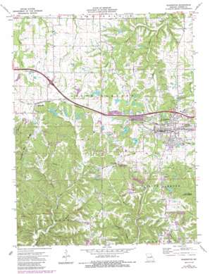
Warrenton Topo Map Missouri
To zoom in, hover over the map of Warrenton
USGS Topo Quad 38091g2 - 1:24,000 scale
| Topo Map Name: | Warrenton |
| USGS Topo Quad ID: | 38091g2 |
| Print Size: | ca. 21 1/4" wide x 27" high |
| Southeast Coordinates: | 38.75° N latitude / 91.125° W longitude |
| Map Center Coordinates: | 38.8125° N latitude / 91.1875° W longitude |
| U.S. State: | MO |
| Filename: | o38091g2.jpg |
| Download Map JPG Image: | Warrenton topo map 1:24,000 scale |
| Map Type: | Topographic |
| Topo Series: | 7.5´ |
| Map Scale: | 1:24,000 |
| Source of Map Images: | United States Geological Survey (USGS) |
| Alternate Map Versions: |
Warrenton MO 1973, updated 1974 Download PDF Buy paper map Warrenton MO 1973, updated 1986 Download PDF Buy paper map Warrenton MO 2012 Download PDF Buy paper map Warrenton MO 2015 Download PDF Buy paper map |
1:24,000 Topo Quads surrounding Warrenton
> Back to 38091e1 at 1:100,000 scale
> Back to 38090a1 at 1:250,000 scale
> Back to U.S. Topo Maps home
Warrenton topo map: Gazetteer
Warrenton: Bridges
E H Winter Bridge (historical) elevation 261m 856′Warrenton: Dams
B and K Lake Number 1 Dam elevation 244m 800′B and K Lake Number 2 Dam elevation 257m 843′
Brady Lake Dam North elevation 231m 757′
Brady Lake Dam South elevation 250m 820′
Carla Company Section 6 Dam elevation 221m 725′
Cedar Grove Dam elevation 246m 807′
Dirkemeier Lake Dam elevation 248m 813′
Dogwood Lake Dam elevation 255m 836′
Huelin McDaniels Dam elevation 253m 830′
Lakeview Estates Dam elevation 259m 849′
Money Sunk Ranch Dam elevation 239m 784′
Niko Lake Dam elevation 256m 839′
Owl Creek Estates Lake Dam elevation 239m 784′
Petersmeyer Lake Dam elevation 256m 839′
Petersmeyers Lower Lake Dam elevation 256m 839′
Reid Lake Section 13 Dam elevation 250m 820′
Sprick Lake Dam elevation 256m 839′
Stein Lake Dam elevation 256m 839′
White, Smith and Austin Lake Dam elevation 268m 879′
Woodridge Lake Dam elevation 244m 800′
Warrenton: Parks
Warrenton State Wildlife Area elevation 285m 935′Warrenton: Populated Places
Lippstadt Community elevation 271m 889′Macedonia Neighborhood elevation 275m 902′
Pendleton elevation 280m 918′
Truesdale elevation 262m 859′
Warrenton elevation 269m 882′
Warrenton: Post Offices
Steinhagen Post Office (historical) elevation 238m 780′Warrenton: Reservoirs
Birkemeier Lake elevation 248m 813′Cedar Grove Lake elevation 246m 807′
Givens Number 1 Lake elevation 250m 820′
Lake Oyate elevation 253m 830′
Lowell Sprick Lake elevation 256m 839′
Money Sunk Ranch Lake elevation 239m 784′
Niko Lake elevation 256m 839′
Ramada Camp Inn Lake elevation 255m 836′
Seven Oaks Ranch Lake elevation 221m 725′
Stein Lake elevation 256m 839′
Warrenton: Ridges
Pendleton Gore Ridge elevation 258m 846′Warrenton: Streams
Clarks Branch elevation 191m 626′Schlanker Branch elevation 202m 662′
Utch Branch elevation 208m 682′
Warrenton: Summits
Roundabout Hill elevation 241m 790′Warrenton: Valleys
Clarks Hollow elevation 192m 629′Turner Hollow elevation 202m 662′
Warrenton digital topo map on disk
Buy this Warrenton topo map showing relief, roads, GPS coordinates and other geographical features, as a high-resolution digital map file on DVD:


