Jefferson City Topo Map Missouri
To zoom in, hover over the map of Jefferson City
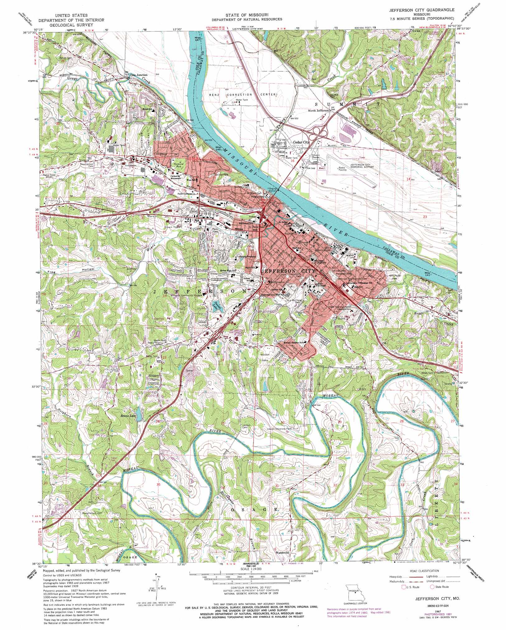
USGS Topo Quad 38092e2 - 1:24,000 scale
| Topo Map Name: | Jefferson City |
| USGS Topo Quad ID: | 38092e2 |
| Print Size: | ca. 21 1/4" wide x 27" high |
| Southeast Coordinates: | 38.5° N latitude / 92.125° W longitude |
| Map Center Coordinates: | 38.5625° N latitude / 92.1875° W longitude |
| U.S. State: | MO |
| Filename: | o38092e2.jpg |
| Download Map JPG Image: | Jefferson City topo map 1:24,000 scale |
| Map Type: | Topographic |
| Topo Series: | 7.5´ |
| Map Scale: | 1:24,000 |
| Source of Map Images: | United States Geological Survey (USGS) |
| Alternate Map Versions: |
Jefferson City MO 1939 Download PDF Buy paper map Jefferson City MO 1939, updated 1940 Download PDF Buy paper map Jefferson City MO 1967, updated 1968 Download PDF Buy paper map Jefferson City MO 1967, updated 1975 Download PDF Buy paper map Jefferson City MO 1967, updated 1982 Download PDF Buy paper map Jefferson City MO 1967, updated 1986 Download PDF Buy paper map Jefferson City MO 1980, updated 1981 Download PDF Buy paper map Jefferson City MO 2011 Download PDF Buy paper map Jefferson City MO 2015 Download PDF Buy paper map |
1:24,000 Topo Quads surrounding Jefferson City
Jamestown |
Ashland |
Millersburg Sw |
Guthrie |
Fulton |
Centertown Nw |
Hartsburg |
Jefferson City Nw |
New Bloomfield |
Mokane West |
Russellville |
Lohman |
Jefferson City |
Osage City |
Loose Creek |
Enon |
Brazito |
Wardsville |
Westphalia West |
Westphalia East |
Eugene |
Saint Elizabeth |
Meta |
Argyle |
Freeburg |
> Back to 38092e1 at 1:100,000 scale
> Back to 38092a1 at 1:250,000 scale
> Back to U.S. Topo Maps home
Jefferson City topo map: Gazetteer
Jefferson City: Airports
Balcer Aero South Airport elevation 191m 626′Charles E Still Hospital Heliport elevation 254m 833′
Jefferson City Memorial Airport elevation 167m 547′
Saint Marys Health Center Heliport elevation 167m 547′
Jefferson City: Bends
Jefferson City Reach elevation 163m 534′Jefferson City: Dams
Gurwit and Lewis Lake Dam elevation 175m 574′Hough Park Dam elevation 205m 672′
Lakewood Dam elevation 210m 688′
Renns Lake Dam elevation 185m 606′
Shadow Lake Dam elevation 213m 698′
Sunset Lake Dam elevation 222m 728′
Trimble Lake East Dam elevation 174m 570′
Trimble Lake West Dam elevation 174m 570′
Jefferson City: Parks
Ellis-Porter Park elevation 176m 577′Hough Park elevation 232m 761′
Jefferson Landing State Historic Site elevation 163m 534′
Lavinia Park elevation 191m 626′
McClung Park elevation 195m 639′
Runge Conservation Nature Center elevation 228m 748′
Washington Park elevation 179m 587′
Jefferson City: Populated Places
Cedar City elevation 168m 551′Cole Junction elevation 170m 557′
Jefferson City elevation 192m 629′
North Jefferson elevation 168m 551′
Jefferson City: Reservoirs
Gurwit and Lewis Lake elevation 175m 574′Hough Park Lake elevation 205m 672′
Lakewood Estates Lake elevation 210m 688′
Number 136 Reservoir elevation 174m 570′
Number 139 Reservoir elevation 174m 570′
Renns Lake elevation 185m 606′
Sunset Lake elevation 226m 741′
Sunset Lake (historical) elevation 222m 728′
Jefferson City: Streams
Boggs Creek elevation 167m 547′Grays Creek elevation 178m 583′
Herbrandt Branch elevation 170m 557′
Neighorn Branch elevation 170m 557′
Turkey Creek elevation 164m 538′
Wears Creek elevation 169m 554′
Jefferson City: Valleys
Frog Hollow elevation 184m 603′Jefferson City digital topo map on disk
Buy this Jefferson City topo map showing relief, roads, GPS coordinates and other geographical features, as a high-resolution digital map file on DVD: