Jamestown Topo Map Missouri
To zoom in, hover over the map of Jamestown
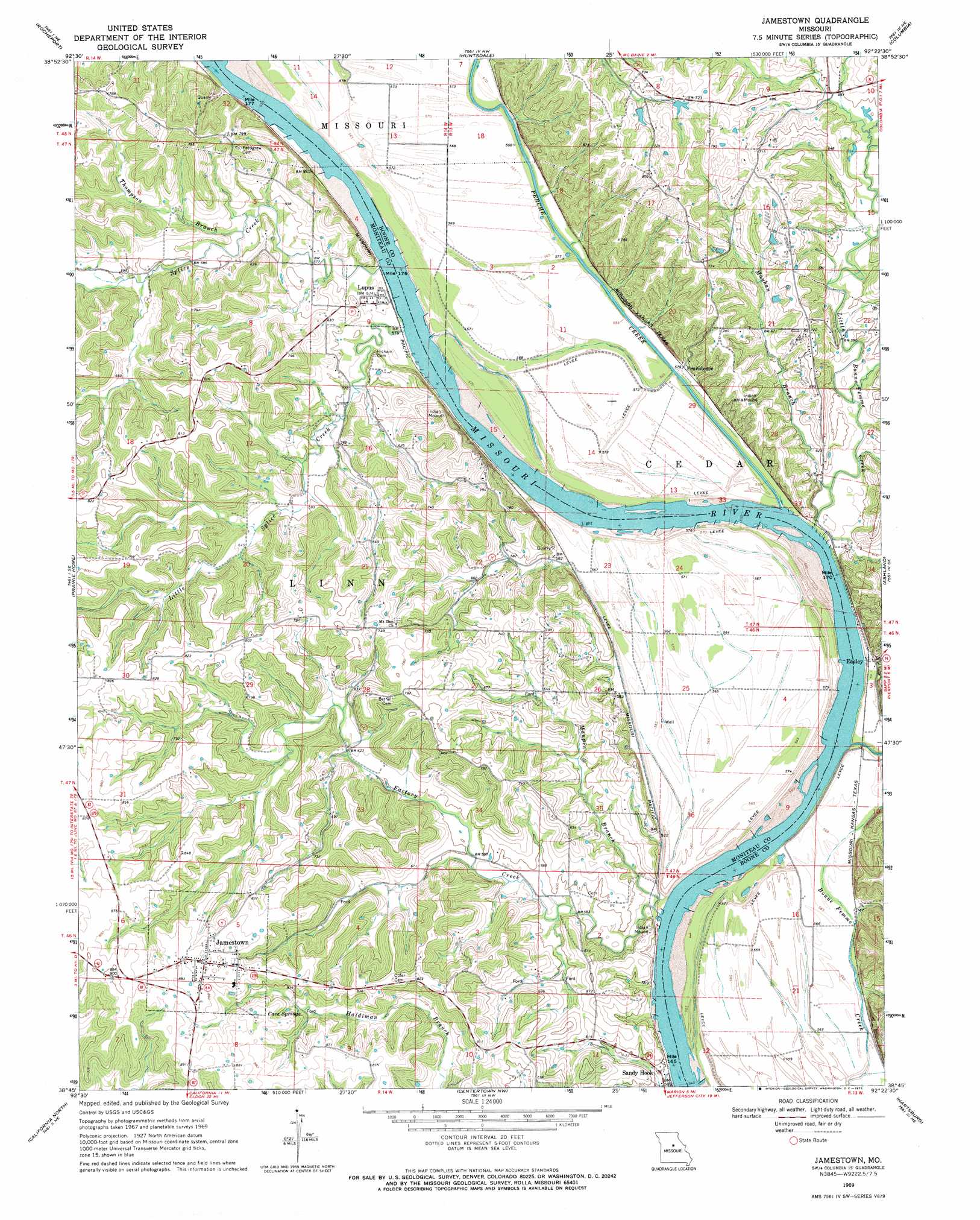
USGS Topo Quad 38092g4 - 1:24,000 scale
| Topo Map Name: | Jamestown |
| USGS Topo Quad ID: | 38092g4 |
| Print Size: | ca. 21 1/4" wide x 27" high |
| Southeast Coordinates: | 38.75° N latitude / 92.375° W longitude |
| Map Center Coordinates: | 38.8125° N latitude / 92.4375° W longitude |
| U.S. State: | MO |
| Filename: | o38092g4.jpg |
| Download Map JPG Image: | Jamestown topo map 1:24,000 scale |
| Map Type: | Topographic |
| Topo Series: | 7.5´ |
| Map Scale: | 1:24,000 |
| Source of Map Images: | United States Geological Survey (USGS) |
| Alternate Map Versions: |
Jamestown MO 1969, updated 1971 Download PDF Buy paper map Jamestown MO 2012 Download PDF Buy paper map Jamestown MO 2015 Download PDF Buy paper map |
1:24,000 Topo Quads surrounding Jamestown
New Franklin |
Hilldale |
Sturgeon Sw |
Browns |
Hallsville |
Boonville |
Rocheport |
Huntsdale |
Columbia |
Millersburg |
Lone Elm |
Prairie Home |
Jamestown |
Ashland |
Millersburg Sw |
Clarksburg |
California North |
Centertown Nw |
Hartsburg |
Jefferson City Nw |
Latham |
California South |
Russellville |
Lohman |
Jefferson City |
> Back to 38092e1 at 1:100,000 scale
> Back to 38092a1 at 1:250,000 scale
> Back to U.S. Topo Maps home
Jamestown topo map: Gazetteer
Jamestown: Arches
Roche Percée Natural Arch elevation 192m 629′Jamestown: Bends
Lupus Bend elevation 172m 564′Plow Boy Bend elevation 171m 561′
Providence Bend elevation 170m 557′
Jamestown: Dams
Smith Hatchery Lake Dam elevation 192m 629′Woodbine Lake Dam elevation 213m 698′
Jamestown: Populated Places
Easley elevation 181m 593′Jamestown elevation 265m 869′
Lupus elevation 175m 574′
Nashville (historical) elevation 170m 557′
Providence elevation 177m 580′
Jamestown: Reservoirs
Smith Hatchery Lake elevation 192m 629′Jamestown: Springs
Cave Springs elevation 232m 761′Jamestown: Streams
Factory Creek elevation 172m 564′Little Bonne Femme Creek elevation 171m 561′
Little Splice Creek elevation 172m 564′
Maupin Branch elevation 172m 564′
Mayhan Branch elevation 171m 561′
Perche Creek elevation 170m 557′
Splice Creek elevation 175m 574′
Thompson Branch elevation 175m 574′
Jamestown digital topo map on disk
Buy this Jamestown topo map showing relief, roads, GPS coordinates and other geographical features, as a high-resolution digital map file on DVD: