Quincy Topo Map Missouri
To zoom in, hover over the map of Quincy
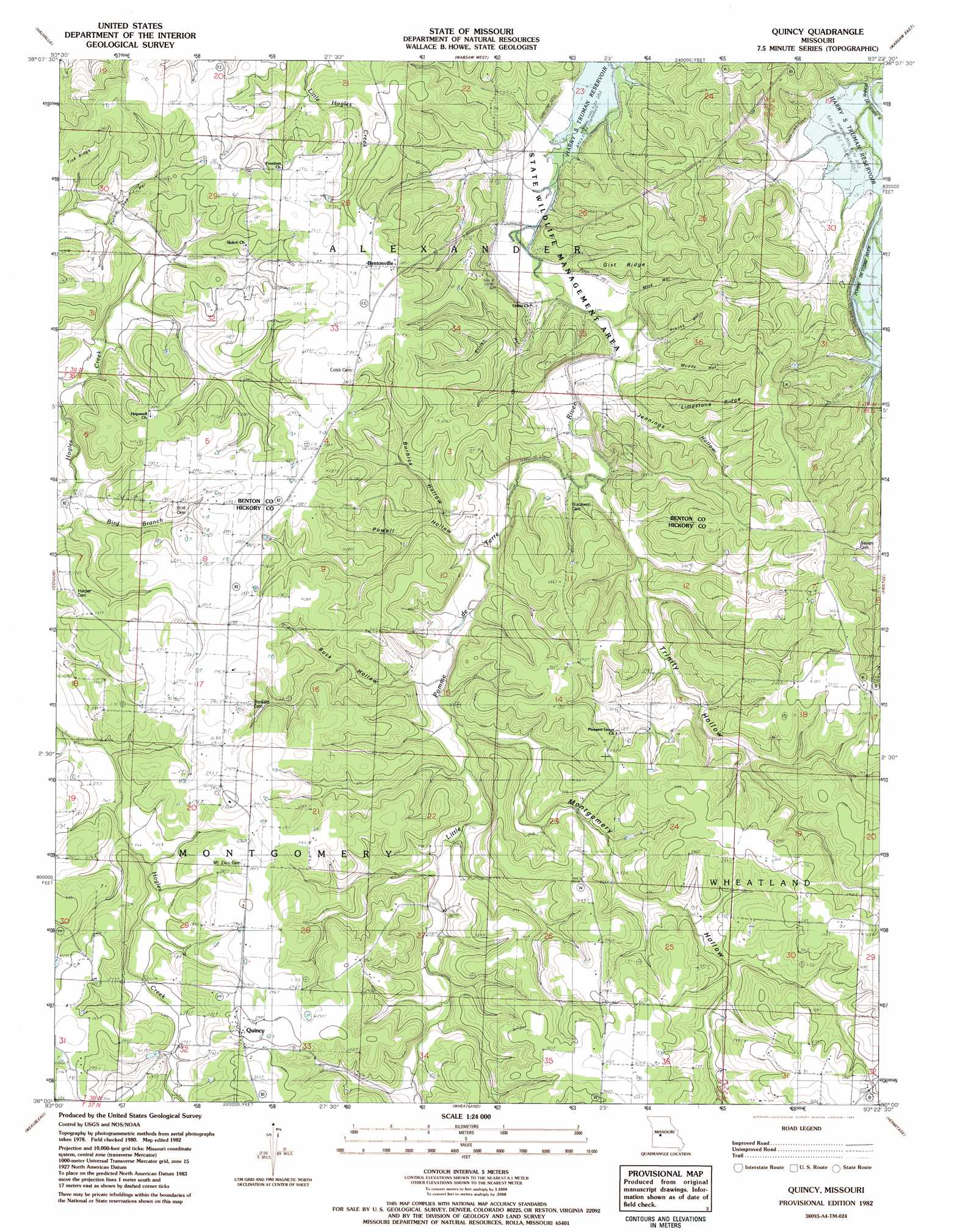
USGS Topo Quad 38093a4 - 1:24,000 scale
| Topo Map Name: | Quincy |
| USGS Topo Quad ID: | 38093a4 |
| Print Size: | ca. 21 1/4" wide x 27" high |
| Southeast Coordinates: | 38° N latitude / 93.375° W longitude |
| Map Center Coordinates: | 38.0625° N latitude / 93.4375° W longitude |
| U.S. State: | MO |
| Filename: | o38093a4.jpg |
| Download Map JPG Image: | Quincy topo map 1:24,000 scale |
| Map Type: | Topographic |
| Topo Series: | 7.5´ |
| Map Scale: | 1:24,000 |
| Source of Map Images: | United States Geological Survey (USGS) |
| Alternate Map Versions: |
Quincy MO 1980, updated 1982 Download PDF Buy paper map Quincy MO 1982, updated 1982 Download PDF Buy paper map Quincy MO 2011 Download PDF Buy paper map Quincy MO 2014 Download PDF Buy paper map |
1:24,000 Topo Quads surrounding Quincy
Gaines |
Leesville |
Shawnee Bend |
Lincoln Se |
Lakeview Heights |
Lowry City |
Valhalla |
Warsaw West |
Warsaw East |
Edwards |
Osceola |
Iconium |
Quincy |
Fristoe |
Cross Timbers |
Vista |
Weaubleau |
Wheatland |
Hermitage |
Preston |
Arnica |
Humansville |
Elkton |
Sentinel |
Urbana |
> Back to 38093a1 at 1:100,000 scale
> Back to 38092a1 at 1:250,000 scale
> Back to U.S. Topo Maps home
Quincy topo map: Gazetteer
Quincy: Populated Places
Bentonville elevation 285m 935′Quincy elevation 301m 987′
Quincy: Ridges
Gist Ridge elevation 268m 879′Limestone Ridge elevation 284m 931′
Tick Ridge elevation 295m 967′
Quincy: Streams
Cover Branch elevation 254m 833′Gover Branch elevation 254m 833′
Quincy: Valleys
Bird Hollow elevation 253m 830′Buck Hollow elevation 239m 784′
Burbick Hollow elevation 233m 764′
Button Hollow elevation 229m 751′
Franks Hollow elevation 221m 725′
Jennings Hollow elevation 224m 734′
Mize Hollow elevation 220m 721′
Montgomery Hollow elevation 235m 770′
Muddy Hollow elevation 222m 728′
Powell Hollow elevation 242m 793′
Trinity Hollow elevation 228m 748′
Turnip Top Hollow elevation 245m 803′
Quincy digital topo map on disk
Buy this Quincy topo map showing relief, roads, GPS coordinates and other geographical features, as a high-resolution digital map file on DVD: