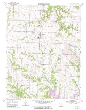
Leeton Topo Map Missouri
To zoom in, hover over the map of Leeton
USGS Topo Quad 38093e6 - 1:24,000 scale
| Topo Map Name: | Leeton |
| USGS Topo Quad ID: | 38093e6 |
| Print Size: | ca. 21 1/4" wide x 27" high |
| Southeast Coordinates: | 38.5° N latitude / 93.625° W longitude |
| Map Center Coordinates: | 38.5625° N latitude / 93.6875° W longitude |
| U.S. State: | MO |
| Filename: | o38093e6.jpg |
| Download Map JPG Image: | Leeton topo map 1:24,000 scale |
| Map Type: | Topographic |
| Topo Series: | 7.5´ |
| Map Scale: | 1:24,000 |
| Source of Map Images: | United States Geological Survey (USGS) |
| Alternate Map Versions: |
Leeton MO 1955, updated 1956 Download PDF Buy paper map Leeton MO 1955, updated 1982 Download PDF Buy paper map Leeton MO 2011 Download PDF Buy paper map Leeton MO 2014 Download PDF Buy paper map |
1:24,000 Topo Quads surrounding Leeton
> Back to 38093e1 at 1:100,000 scale
> Back to 38092a1 at 1:250,000 scale
> Back to U.S. Topo Maps home
Leeton topo map: Gazetteer
Leeton: Dams
Groff Lake Dam elevation 276m 905′Tebo Diversionary Impoundment Dam elevation 239m 784′
Wilson Lake Dam elevation 274m 898′
Windsor Lake Dam elevation 250m 820′
Leeton: Populated Places
Leeton elevation 289m 948′New Castle elevation 271m 889′
Leeton: Reservoirs
Number 106 Lake elevation 276m 905′Number 131 Reservoir elevation 239m 784′
Wilson Lake elevation 274m 898′
Leeton: Streams
Little Tebo Creek elevation 234m 767′Leeton digital topo map on disk
Buy this Leeton topo map showing relief, roads, GPS coordinates and other geographical features, as a high-resolution digital map file on DVD:


