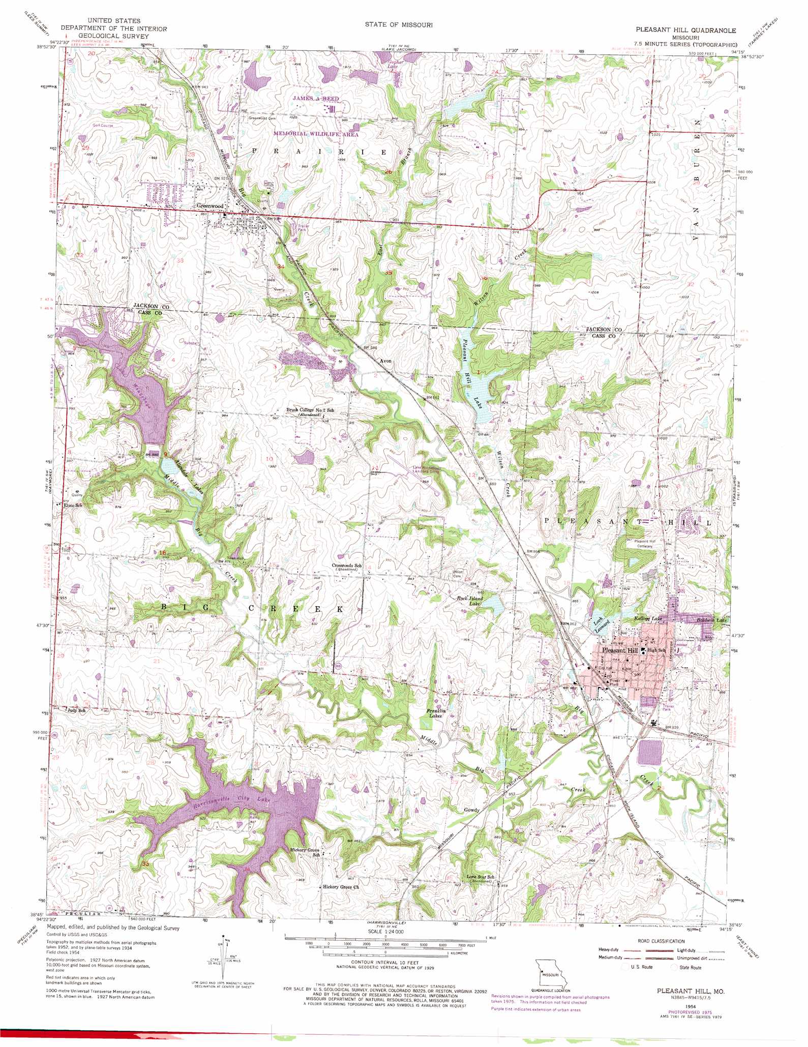
Pleasant Hill Topo Map Missouri
To zoom in, hover over the map of Pleasant Hill
USGS Topo Quad 38094g3 - 1:24,000 scale
| Topo Map Name: | Pleasant Hill |
| USGS Topo Quad ID: | 38094g3 |
| Print Size: | ca. 21 1/4" wide x 27" high |
| Southeast Coordinates: | 38.75° N latitude / 94.25° W longitude |
| Map Center Coordinates: | 38.8125° N latitude / 94.3125° W longitude |
| U.S. State: | MO |
| Filename: | o38094g3.jpg |
| Download Map JPG Image: | Pleasant Hill topo map 1:24,000 scale |
| Map Type: | Topographic |
| Topo Series: | 7.5´ |
| Map Scale: | 1:24,000 |
| Source of Map Images: | United States Geological Survey (USGS) |
| Alternate Map Versions: |
Pleasant Hill MO 1934 Download PDF Buy paper map Pleasant Hill MO 1954, updated 1955 Download PDF Buy paper map Pleasant Hill MO 1954, updated 1976 Download PDF Buy paper map Pleasant Hill MO 1990, updated 1995 Download PDF Buy paper map Pleasant Hill MO 2012 Download PDF Buy paper map Pleasant Hill MO 2015 Download PDF Buy paper map |
1:24,000 Topo Quads surrounding Pleasant Hill
Kansas City |
Independence |
Blue Springs |
Oak Grove |
Bates City |
Grandview |
Lees Summit |
Lake Jacomo |
Tarsney Lakes |
Chapel Hill |
Belton |
Raymore |
Pleasant Hill |
Strasburg |
Elm |
West Line |
Peculiar |
Harrisonville |
East Lynne |
Kingsville |
Freeman |
Everett |
Austin |
Garden City |
Quick City |
> Back to 38094e1 at 1:100,000 scale
> Back to 38094a1 at 1:250,000 scale
> Back to U.S. Topo Maps home
Pleasant Hill topo map: Gazetteer
Pleasant Hill: Airports
Inter-State Airport elevation 288m 944′Lake Winnebago Municipal Airport (historical) elevation 291m 954′
Riordan Airport elevation 299m 980′
Pleasant Hill: Dams
Allendale Dam elevation 286m 938′Bluestem Lake Dam elevation 297m 974′
Bodarc Lake Dam elevation 290m 951′
Fairview Farms Lake Dam elevation 284m 931′
Gopher Lake Dam elevation 288m 944′
Haake Lake Dam elevation 281m 921′
Harrisonville City Lake Dam elevation 273m 895′
Lake Winnebago Dam elevation 279m 915′
Loch Leonard Dam elevation 264m 866′
Mononame 697 Dam elevation 272m 892′
Pleasant Hill Lake Dam elevation 272m 892′
Reed Area Number 3 Dam elevation 296m 971′
Swan Lake Dam elevation 285m 935′
Pleasant Hill: Populated Places
Avon elevation 272m 892′Crossroads School elevation 299m 980′
Gowdy elevation 261m 856′
Greenwood elevation 290m 951′
Lake Winnebago elevation 295m 967′
Pleasant Hill elevation 277m 908′
Wyoming (historical) elevation 265m 869′
Pleasant Hill: Post Offices
Greenwood Post Office elevation 282m 925′Pleasant Hill: Reservoirs
Allendale Lake elevation 286m 938′Allendale Lakes elevation 269m 882′
Coot Lake elevation 296m 971′
Franklin Lakes elevation 264m 866′
Gopher Lake elevation 288m 944′
Haake Lake elevation 281m 921′
Harrisonville City Lake elevation 273m 895′
Harrisonville Lake elevation 273m 895′
Kellogg Lake elevation 269m 882′
Lake Winnebago elevation 279m 915′
Loch Leonard elevation 264m 866′
Nelly Don Lake elevation 284m 931′
Pleasant Hill Lake elevation 272m 892′
Reed Area Number 10 Lake elevation 297m 974′
Reed Area Number 9 Lake elevation 290m 951′
Rock Island Lake elevation 270m 885′
Swan Lake elevation 285m 935′
Pleasant Hill: Streams
East Branch elevation 267m 875′Middle Big Creek elevation 257m 843′
Wilson Creek elevation 263m 862′
Pleasant Hill digital topo map on disk
Buy this Pleasant Hill topo map showing relief, roads, GPS coordinates and other geographical features, as a high-resolution digital map file on DVD: