De Soto Topo Map Kansas
To zoom in, hover over the map of De Soto
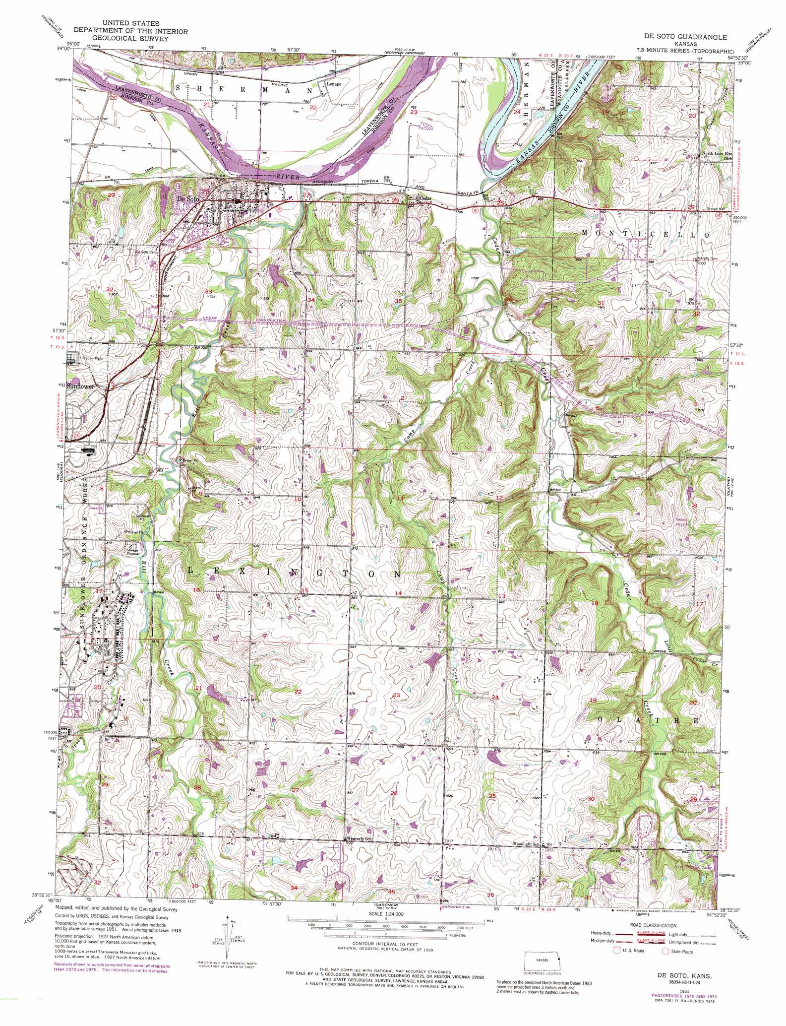
USGS Topo Quad 38094h8 - 1:24,000 scale
| Topo Map Name: | De Soto |
| USGS Topo Quad ID: | 38094h8 |
| Print Size: | ca. 21 1/4" wide x 27" high |
| Southeast Coordinates: | 38.875° N latitude / 94.875° W longitude |
| Map Center Coordinates: | 38.9375° N latitude / 94.9375° W longitude |
| U.S. State: | KS |
| Filename: | o38094h8.jpg |
| Download Map JPG Image: | De Soto topo map 1:24,000 scale |
| Map Type: | Topographic |
| Topo Series: | 7.5´ |
| Map Scale: | 1:24,000 |
| Source of Map Images: | United States Geological Survey (USGS) |
| Alternate Map Versions: |
De Soto KS 1951, updated 1952 Download PDF Buy paper map De Soto KS 1951, updated 1967 Download PDF Buy paper map De Soto KS 1951, updated 1971 Download PDF Buy paper map De Soto KS 1951, updated 1976 Download PDF Buy paper map De Soto KS 1951, updated 1989 Download PDF Buy paper map De Soto KS 1991, updated 1996 Download PDF Buy paper map De Soto KS 2009 Download PDF Buy paper map De Soto KS 2012 Download PDF Buy paper map De Soto KS 2015 Download PDF Buy paper map |
1:24,000 Topo Quads surrounding De Soto
Mclouth |
Jarbalo |
Basehor |
Wolcott |
Parkville |
Midland |
Tonganoxie |
Bonner Springs |
Edwardsville |
Shawnee |
Lawrence East |
Eudora |
De Soto |
Olathe |
Lenexa |
Baldwin City |
Edgerton |
Gardner |
Ocheltree |
Stilwell |
Le Loup |
Wellsville |
Antioch |
Spring Hill |
Bucyrus |
> Back to 38094e1 at 1:100,000 scale
> Back to 38094a1 at 1:250,000 scale
> Back to U.S. Topo Maps home
De Soto topo map: Gazetteer
De Soto: Airports
Cedar Air Park elevation 308m 1010′De Soto: Bridges
De Soto Railroad Bridge elevation 262m 859′De Soto: Dams
New Olathe Lake Dam elevation 287m 941′Sunflower Pond B Dam elevation 261m 856′
De Soto: Lakes
Johnson County Kill Creek Park North elevation 267m 875′Johnson County Kill Creek Park South elevation 272m 892′
Kill Creek Pond North elevation 268m 879′
Kill Creek Pond South elevation 277m 908′
De Soto: Parks
Kill Creek Park elevation 290m 951′Kill Creek Park elevation 290m 951′
Kill Creek Park Beach elevation 269m 882′
Miller Memorial Park elevation 241m 790′
Timberridge Adventure Center elevation 281m 921′
De Soto: Populated Places
B And L Mobile Home Park elevation 261m 856′Bosworth Mobile Home Park elevation 253m 830′
Cedar elevation 248m 813′
De Soto elevation 262m 859′
De Soto Mobile Home Park elevation 245m 803′
Lenape elevation 239m 784′
Pingleton Mobile Home Park elevation 244m 800′
Warsop Mobile Home Park elevation 245m 803′
De Soto: Post Offices
De Soto Post Office elevation 263m 862′De Soto: Reservoirs
Beach Lake elevation 267m 875′Kill Creek Park Lake elevation 267m 875′
New Olathe Lake elevation 287m 941′
Prairie Center Pond elevation 298m 977′
De Soto: Streams
Camp Creek elevation 239m 784′Cedar Creek elevation 236m 774′
Kill Creek elevation 234m 767′
Little Cedar Creek elevation 256m 839′
Spoon Creek elevation 245m 803′
De Soto: Trails
Kill Creek Streamway Trail elevation 240m 787′De Soto digital topo map on disk
Buy this De Soto topo map showing relief, roads, GPS coordinates and other geographical features, as a high-resolution digital map file on DVD: