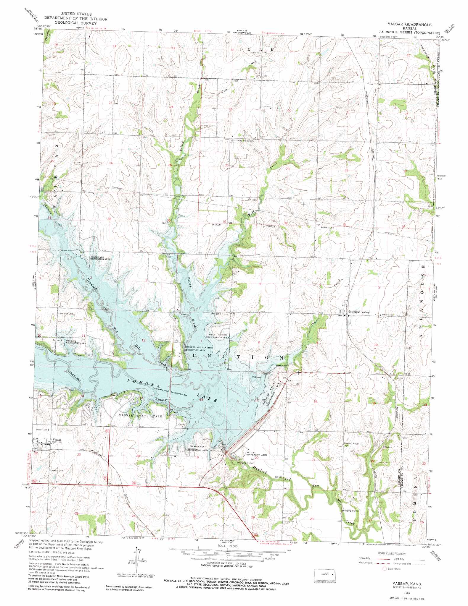
Vassar Topo Map Kansas
To zoom in, hover over the map of Vassar
USGS Topo Quad 38095f5 - 1:24,000 scale
| Topo Map Name: | Vassar |
| USGS Topo Quad ID: | 38095f5 |
| Print Size: | ca. 21 1/4" wide x 27" high |
| Southeast Coordinates: | 38.625° N latitude / 95.5° W longitude |
| Map Center Coordinates: | 38.6875° N latitude / 95.5625° W longitude |
| U.S. State: | KS |
| Filename: | o38095f5.jpg |
| Download Map JPG Image: | Vassar topo map 1:24,000 scale |
| Map Type: | Topographic |
| Topo Series: | 7.5´ |
| Map Scale: | 1:24,000 |
| Source of Map Images: | United States Geological Survey (USGS) |
| Alternate Map Versions: |
Vassar KS 1965, updated 1966 Download PDF Buy paper map Vassar KS 1965, updated 1982 Download PDF Buy paper map Vassar KS 2010 Download PDF Buy paper map Vassar KS 2012 Download PDF Buy paper map Vassar KS 2015 Download PDF Buy paper map |
1:24,000 Topo Quads surrounding Vassar
Auburn |
Wakarusa |
Richland |
Clinton |
Lawrence West |
Burlingame |
Carbondale |
Overbrook |
Globe |
Lone Star |
Osage City |
Lyndon Nw |
Vassar |
Ottawa Nw |
Ottawa North |
Osage City Se |
Lyndon |
Quenemo |
Pomona |
Ottawa South |
Lebo |
Waverly Nw |
Waverly |
Williamsburg |
Richmond |
> Back to 38095e1 at 1:100,000 scale
> Back to 38094a1 at 1:250,000 scale
> Back to U.S. Topo Maps home
Vassar topo map: Gazetteer
Vassar: Dams
Pomona Dam elevation 301m 987′Vassar: Parks
Dragoon Recreation Area elevation 312m 1023′Hundred and Ten Mile Recreation Area elevation 314m 1030′
Michigan Valley Recreation Area elevation 323m 1059′
Outlet Recreation Area elevation 288m 944′
Pomona State Park elevation 312m 1023′
Wolf Creek Recreation Area elevation 317m 1040′
Vassar: Populated Places
Michigan Valley elevation 327m 1072′Vassar elevation 338m 1108′
Vassar: Reservoirs
Pomona Lake elevation 301m 987′Vassar: Streams
Coon Creek elevation 297m 974′Dragoon Creek elevation 297m 974′
Jim Creek elevation 316m 1036′
Plummer Creek elevation 297m 974′
Valley Brook elevation 297m 974′
Wolf Creek elevation 297m 974′
Vassar digital topo map on disk
Buy this Vassar topo map showing relief, roads, GPS coordinates and other geographical features, as a high-resolution digital map file on DVD: