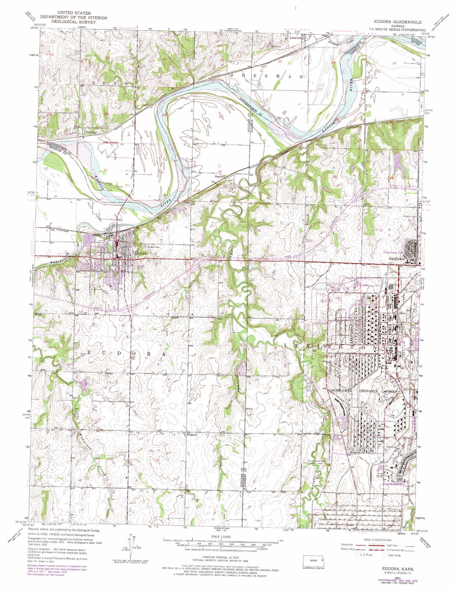
Eudora Topo Map Kansas
To zoom in, hover over the map of Eudora
USGS Topo Quad 38095h1 - 1:24,000 scale
| Topo Map Name: | Eudora |
| USGS Topo Quad ID: | 38095h1 |
| Print Size: | ca. 21 1/4" wide x 27" high |
| Southeast Coordinates: | 38.875° N latitude / 95° W longitude |
| Map Center Coordinates: | 38.9375° N latitude / 95.0625° W longitude |
| U.S. State: | KS |
| Filename: | o38095h1.jpg |
| Download Map JPG Image: | Eudora topo map 1:24,000 scale |
| Map Type: | Topographic |
| Topo Series: | 7.5´ |
| Map Scale: | 1:24,000 |
| Source of Map Images: | United States Geological Survey (USGS) |
| Alternate Map Versions: |
Eudora KS 1951, updated 1952 Download PDF Buy paper map Eudora KS 1951, updated 1968 Download PDF Buy paper map Eudora KS 1951, updated 1971 Download PDF Buy paper map Eudora KS 1951, updated 1978 Download PDF Buy paper map Eudora KS 2009 Download PDF Buy paper map Eudora KS 2012 Download PDF Buy paper map Eudora KS 2015 Download PDF Buy paper map |
1:24,000 Topo Quads surrounding Eudora
Oskaloosa |
Mclouth |
Jarbalo |
Basehor |
Wolcott |
Williamstown |
Midland |
Tonganoxie |
Bonner Springs |
Edwardsville |
Lawrence West |
Lawrence East |
Eudora |
De Soto |
Olathe |
Lone Star |
Baldwin City |
Edgerton |
Gardner |
Ocheltree |
Ottawa North |
Le Loup |
Wellsville |
Antioch |
Spring Hill |
> Back to 38095e1 at 1:100,000 scale
> Back to 38094a1 at 1:250,000 scale
> Back to U.S. Topo Maps home
Eudora topo map: Gazetteer
Eudora: Dams
Roberts Lake Dam elevation 273m 895′Eudora: Lakes
Sunflower Park Lake elevation 279m 915′Eudora: Parks
Sunflower Nature Park elevation 280m 918′Sunflower Park elevation 280m 918′
Eudora: Populated Places
Clearview City elevation 279m 915′Eudora elevation 256m 839′
Fall Leaf elevation 252m 826′
Grandview Mobile Home Park elevation 257m 843′
Hesper elevation 281m 921′
Weaver elevation 244m 800′
Eudora: Post Offices
Eudora Post Office elevation 259m 849′Eudora: Reservoirs
Roberts Lake elevation 273m 895′Sunflower Park Lake elevation 267m 875′
Eudora: Streams
Captain Creek elevation 236m 774′Coleman Creek elevation 246m 807′
Kent Creek elevation 243m 797′
Stranger Creek elevation 237m 777′
Wakarusa River elevation 238m 780′
Eudora: Summits
Observation Bluff elevation 276m 905′Eudora digital topo map on disk
Buy this Eudora topo map showing relief, roads, GPS coordinates and other geographical features, as a high-resolution digital map file on DVD: